
Description of the nominated property
The nominated propery is a serial site, consisting of 7 different areas located in the provinces of Reggio Emilia, Bologna, Ravenna, and Rimini
The nominated property extends over a territory consisting of 7 component sites. It surrounds the entire straight ridge of evaporite outcrops that emerges on the northern slopes of the Apennines, from the “Vena del Gesso Romagnola” to the Secchia River Valley , which exposes, by erosion, some older evaporite deposits. The boundaries of the nominated property extend also underground, to include the cavities produced by karst phenomena.
All the major known caves in evaporites are included in the nominated property and are protected by Regional, National and International laws.
The boundaries take into account the extension of the whole karstic system, including the hydrogeological circulation and alimentation basin. A particular attention has been posed to include all the historical study areas, due to the relevance that these places had in the development of evaporite speleology, mineralogy and hydrogeology disciplines.
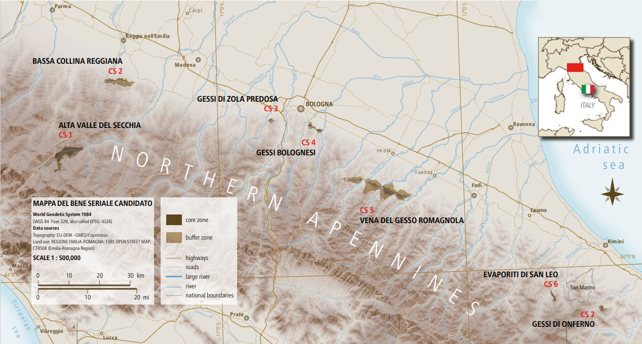
The areas and the coordinates of the centroid of each component site are as follows
ID 119 ha | ID Name of the component part | Latitude of the central point | Longitude of the central point | Area of nominated component part (ha) | Area of the Buffer Zone (ha) |
|---|---|---|---|---|---|
c.s. 1 | Alta Valle Secchia | 44° 21' 41" N | 10° 23' 10" E | 1596 ha | 1294 ha |
c.s. 2 | Bassa Collina Reggiana | 44° 35' 06" N | 10° 35' 56" E | 274 ha | 1385 ha |
c.s. 3 | Gessi di Zola Predosa | 44° 27' 40" N | 11° 13' 13" E | 57 ha | 128 ha |
c.s. 4 | Gessi Bolognesi | 44° 26' 15" N | 11° 24' 00" E | 237 ha | 325 ha |
c.s. 5 | Vena del Gesso Romagnola | 44° 15' 07" N | 11° 38' 38" E | 1313 ha | 4775 ha |
c.s. 6 | Evaporiti di San Leo | 43° 55' 05" N | 12° 20' 45" E | 119 ha | 165 ha |
c.s. 7 | Gessi di Onferno | 43° 52' 30" N | 12° 32' 51" E | 84 ha | 276 ha |
3 680 ha | 8 348 ha |