Preliminary analysis for assessment of geothermal potential in Emilia-Romagna
Analysis of data
Emilia-Romagna Region backed a geological study into the potential of geothermal energy in the Region as early as the 1980s (RER, CNR, 1982). One of the key conclusions of this study was that positive heat anomalies (thermal springs in the Apennines and positive heat anomalies measured in deep wells on the Po Plain) must be attributed to the tectonic structures.
According to the findings of this study, the presence of Apennine thermal springs can be explained by the deep circulation of meteoric water, which percolates down through the subsoil and rises again to the surface along faults (MERLO et al., 1988; COLOMBETTI and NICOLODI, 2005), while positive heat anomalies on the plain, nearly all recorded in wells located above the buried ridge known as the Ferrara Folds (PIERI and GROPPI, 1981), are attributable to deep circulation that reaches the carbonate sequence located a few hundred metres below the surface thanks to the presence of the positive tectonic structure of the Ferrara Folds.
Since the geological conditions which characterize the subsoil of Ferrara and Apennine thermal springs also exist in other parts of the region, there are very real possibilities of finding other geothermal fields.
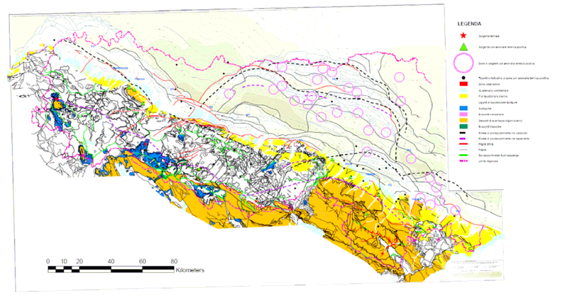
Fig. 1 - Cartographic synthesis of data
Starting from the conclusions reached by RER, CNR (1982), available geological data on the tectonic arrangement of the Apennines, the Po Plain and the Adriatic coast were re-read (CERRINA FERONI et al., 2002; BOCCALETTI et al., 2004) and a preliminary map (Fig. 1) which compares the main tectonic elements of the region with localization of hot springs was compiled.
This map indicates that thermal springs are predominantly located in “tectonic windows” or in close proximity to regional fault zones. Many of these structures have shown recent activity (BOCCALETTI et al., 2004).
It is also interesting to note that all the main Apennine thermal springs are found in the hanging wall of the thrust responsible for the doubling of the crystalline basement (ARGNANI et al., 1997; BOCCALETTI et al., 2004), the uplift of deeper units (Mesozoic carbonate sequence, Oligo-Miocene Tuscan-Romagna successions) and the erosion of allochthonous units (Ligurian nappe) which are greatly reduced or even absent in this area (tectonic windows). Areas of the plain with warmer deep waters are primarily found above the entire arc of the Ferrara ridge, between Reggio Emilia and Ravenna, along the coast between Cervia (Ravenna Province) and Rimini, i.e. above the northern extremity of the Adriatic Folds, and between Reggio Emilia and Fiorenzuola d’Arda (Piacenza Province), above the SE sector of the Emilia Folds. These buried structures, especially in the above-indicated sectors, also display evidence of recent activity (BURRATO et al., 2003; VANNOLI et al., 2004; BOCCALETTI et al., 2004).
Preliminary conclusions and working hypotheses
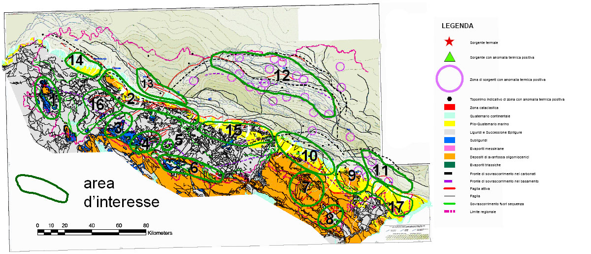
Fig. 2 - Proposed areas of interest for more in-depth study
From this preliminary analysis, it transpires that the areas of greatest interest for further in-depth analysis of potential geothermal reservoirs in Emilia-Romagna are those at the top of the structural highs with evidence of recent activity (areas 1-17 in the Fig. 2).
Appendix 1 presents a working hypothesis and the methodology.
Appendix 1 - Operative proposal for assessment of geothermal potential in Emilia-Romagna
The following activities, listed in order of sequential realization, are proposed for the assessment of geothermal potential in Emilia-Romagna.
a) Historical research
For optimum definition of areas of interest, extensive bibliographic research and collation of previous data is necessary. This must include:
- geographical localization
- analytical data
- historical character of areas of interest in order to assess the temporal continuity of phenomena
Bibliographic research must be extended to include all bodies (C.N.R., Universities, ENEL, ENI-Agip) which have investigated this type of resource. Given that in Emilia-Romagna we are dealing mostly with low-enthalpy phenomena, we can presume that such resources have been recorded but not identified as strategic resources. Analytical data where found is particularly interesting for characterisation purposes.
b) Geochemical and overall stratigraphic/structural assessment of areas of interest
All chemical data relating to spring, thermal and well water must be processed in order to define the most complete geochemical model possible: this will enable appropriate planning of the subsequent exploration phases.
Alongside geochemical data, geognostic data for areas close to potential geothermal fields (seismic lines, drilled wells…) should be collected and preliminarily analyzed in order to establish a preliminary calibration of geochemical data, considering the geological/structural context.
c) Identification of test areas for a pilot study
After preliminary analysis for assessment of geothermal potential in Emilia Romagna and based on the geothermal anomalies found in AGIP wells, the next step is to identify potentially interesting but as yet unexplored areas for in-depth pilot studies for validation of the proposed methodology and actual assessment of geothermal potential. For example, pilot studies could be carried out in the area between Collecchio and Monticelli Terme (structural high of the Emilia Folds) or in the area between Mirandola and Novi di Modena (structural high of the Ferrara Folds), on the plain, in the area of Lesignano Bagni, in the context of the Po Plain-Apenninic margin (structural high of the Pede-Apenninic thrust front) and at Miano (tectonic window of the upper Parma valley) or between the Montone and Tramazzo rivers (Romagna Apennines), in the Apenninic chain. The choice of test area must in any case be agreed with those bodies which will participate in the studies, based on interests and on available resources (data, economic resources, time, objectives).
Pilot studies in the test areas entail the following study phases.
- c.1) Analysis of deep geological data of test area
For the definition of the geometric limits of the potential geothermal reservoir, stratigraphic data and available seismic profiles must be analyzed and other stratigraphies and profiles of the area of interest must be consulted. This entails extending research to companies (ENI-Agip, SPI, LASMO, other companies, …) which drilled deep test wells for hydrocarbon exploration in Emilia-Romagna and neighbouring areas (cf. available data c/o l’UNMIG, Ufficio F5, Bologna). From identification of the principal lithological and tectonic discontinuities of the subsoil, it will be possible to define the hydrogeological limits and deep water circulation. In particular, links between faults and carbonate, Oligocene-Miocene and Pliocene-Quaternary sequences must be investigated in order to identify deep structures which reach depths in proximity to the surface (< 1000 m, in general in the order of 300-500 m from the topographic surface on the plain, sometimes outcropping in the Apennines) - c.2) Analysis of surface geological data of the test area
Point c.1 must be integrated with analysis of the cartography and aerial photos and satellite images in order to identify evidence on the surface of deep fractures and faults. - c.3) Surface prospection in the test area
Census/survey of springs and chemical-physical analysis of waters and gas and their geochemical processing in order to obtain valuable data for the creation of a subsoil water circulation model. Identification and characterization of the most promising sites of the test area for geothermal energy. - c.4) Measurement of geothermal gradient in the test area
Measurement of temperature in the most significant wells of the test area which potentially reach the geothermal reservoir. - c.5) Exploratory drilling in the test area
Based on the results for the above points (c.1-c.4), planning and drilling of exploratory wells for the assessment of the geothermal potential in the test area (depth, flow, water temperature) and acquisition of data for a possible qualitative/quantitative model of the geothermal reservoir. - c.6) Qualitative/quantitative model of potential geothermal reservoir
Estimate of real potential and simulation of future exploitation.
Points a and b require a limited investment and at the same time enable us to gather detailed information that completes the regional cognitive framework.
Carrying out the activities described at points a and b (research, organization of a data base and elaboration of existing data) will take approximately 8 months.
To make best use of the resources (money and time) required for assessment of geothermal potential, it is deemed wise to focus studies in key test areas which are representative of the main regional territorial contexts (Po Plain, Po Plain-Apenninic margin, Apennine chain) (point c).
Estimation of costs and time for such assessment in test areas (points c.1-c.4) will only be possible after the research described at points a and b.
Planning, and consequently also realization, of any exploratory drilling and thereafter qualitative/quantitative modelling of the potential geothermal reservoir (points c.5 and c.6) is necessarily a consequence of the results of the activities described at points c.1-c.4.
The activities described above require the expertise of a structural geologist with specialist knowledge of the geology of the Northern Apennines, a stratigrapher with specialist knowledge of the geology of the Po Plain subsoil, a geochemist and a computer programmer to organize a database, elaborate data and produce the relevant cartography using GIS.
For the activities described at points a and c.1 agreements will have to be reached and contracts possibly drawn up with other bodies (C.N.R., Universities, ENEL, ENI – Agip, other companies carrying out research into energy resources).
References
ARGNANI, A., BERNINI, M., DI DIO, G., PAPANI, G., ROGLEDI, S., 1997. Stratigraphic record of crustal-scale tectonics in the quaternary of the Northern Apennines (Italy). Il Quaternario, 10 (2), 595-602.
BOCCALETTI, M., BONINI, M., CORTI, G., GASPERINI, P., MARTELLI, L., PICCARDI, L., SEVERI, P., VANNUCCI, G., 2004. Carta Sismotettonica della Regione Emilia-Romagna, scala 1:250.000. Regione Emilia-Romagna, SGSS – CNR-IGG, Florence.
BURRATO, P., CIUCCI, F., VALENSISE, G., 2003. An inventory of river anomalies in the Po Plain, Northern Italy: evidence for active blind thrust faulting. Annals of Geophysics, Vol. 46, N. 5, 865-882.
CERRINA FERONI, A., MARTELLI, L., MARTINELLI, P., OTTRIA, G., 2002. Carta geologico-strutturale dell’Appennino emiliano-romagnolo in scala 1:250.000. Regione Emilia-Romagna – C.N.R., Pisa.
COLOMBETTI, A., NICOLODI, F., 2005. Le sorgenti a bassa termalità di Quara (Comune di Toano – Provincia di Reggio Emilia). Geologia dell’Ambiente – periodical of Soc. It. Geol. Amb. 2005, n. 1, 12-16.
MERLO, C., BOATTINI, E., BENVENUTI, G., 1988. Space heating plant of the Bagno di Romagna municipality (Italy): a successful case of geothermal heat utilization. Geothermics, Vol. 17, No. 1, 237-253.
PIERI, M., GROPPI, G.. 1981. Subsurface geological structure of the Po Plain (Italy). C.N.R., Prog. Fin. Geodinamica, Pubbl. n. 414, 1-13.
RER, CNR, 1982. Caratteri geoidrologici e geotermici dell’Emilia-Romagna. Programmi e prospettive per lo sfruttamento delle risorse geotermiche regionali. Regione Emilia-Romagna e Consiglio Nazionale delle Ricerche. Collana di orientamenti geomorfologici ed agronomico-forestali. pp 177.
VANNOLI, P., BASILI, R., VALENSISE, G., 2004. New geomorphic evidence for anticlinal growth driven by blind-thrust faulting along the northern Marche coastal belt (central Italy). J. of Seismology., 8, 297-314.