Earthquakes of May 2012
Book presentation
Emilia-Romagna Region has invested a great deal in recent years to build up a detailed knowledge base of the territory, of both above and below the Earth’s crust.The driving idea behind this major economic and technical commitment is that this knowledge is an essential requisite for territorial planning, for efficient and sustainable use of natural resources and for the prevention and mitigation of natural risks; in other words, for the safety and wellbeing of the region’s population.Thanks to this undertaking, we now avail of knowledge and technical know-how that significantly shaped our response capability and reaction to the tragic earthquakes of May 2012. On the knowledge front, Emilia-Romagna Region has done ground-breaking work: we have a complete and detailed database on the geology of the subsoil of the plain area and we are the leading authority, nationwide, seismic microzonation studies.In terms of technical capabilities, the great professionalism of the Region’s technicians has enabled us to respond to the population’s needs, providing technical assessments and detailed studies on geological aspects.
None of this would have been possible without the support of the Department for Civil Protection, Professional organizations (Engineers, Architects, Surveyors), ReLUIS (University Seismic Engineering Laboratories Network), Research Institutes, Regional authorities and all those organizations and individuals who were involved in on-site inspections and scientific research.
This publication endeavours to provide an overview of the work carried out by the Geological, Seismic and Soil Survey, by the Po River Basin Technical Service (BTS) and the Regional Civil Protection Agency of Emilia-Romagna in response to the seismic emergency of May 2012. Gathering our experiences together in a book is not simply about preserving the collective memory of those events, but also about expressing our commitment to inform and educate the population of Emilia-Romagna about seismic risk and the natural phenomenon of earthquakes, promoting better knowledge the risks we run and the tools we have developed to face those risks, reducing the threat they pose.
The Emilia-Romagna earthquakes of May 2012
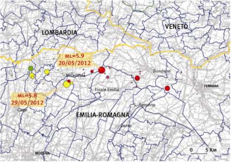
On 20th May 2012, at 4:03 am, an earthquake with a local magnitude (ML) of 5.9 on the Richter scale struck the Po Plain.The epicentre was in the province of Modena, between Mirandola and Finale Emilia, while the depth of the hypocentre was estimated at approx. 6.3 km.A large number of aftershocks were recorded the same day, two of which presented a magnitude of above 5.0.
Nine days later, on 29th May 2012 at 9:00 am, another strong 5.8 ML shock hit the Modena plain once again.The quake’s epicentre was near Medolla, approximately 10 kilometres west of the main earthquake of 20th May, at a depth of approximately 10.2 km.Numerous aftershocks followed that same day, including two with a magnitude above 5.0.
In all, there were seven earthquakes of a magnitude above 5.0, the last of which occurred on 3rd June 2012 at 9:20 pm.
The analysis of observed damage and effects carried out by the Department of Civil Protection-Seismic and Volcanic Risk (Galli et al., 2012) and by the Italian Institute of Geophysics and Vulcanologia-gruppo QUEST (QUEST Working Group, 2012) Volcanology-QUEST group (QUEST Working Group, 2012) identified effects of VII-VIII on the intensity scale, classifying the largest shocks as very strong and destructive.
This sector of the Po Plain had already been affected by earthquakes of an intensity above VII in 1346, in 1570 and in 1796 (Locati et al., 2011) The most recent seismic crises present strong analogies, in terms of damage and environmental effects observed, with the Ferrara earthquake of 1570.
As regards damage, the seismic sequence resulted in damage above all to large buildings, such as castles and towers, churches, bell towers and industrial sheds, with widespread effects caused by liquefaction.
Why the plain trembled
The territory struck by the earthquakes of 20th and 29th May is a morphologically uniform sector of plain, with very modest reliefs in correspondence with the banks of water courses and manmade levees.The subsoil, on the contrary, is rather more complex, as documented by hydrocarbon exploration activities which have revealed significant deformations in the most ancient soils forming the substrate of the Po basin below the recent deposits of the River Po and Apennine rivers.From a geological point of view, the Apennine chain is not limited to what is visible on the surface, but continues underground, deep below the surface of the Po Plain, with a series of geological structures running virtually parallel to the Apennines which extend to the current course of the River Po. Although they are not visible, from a seismic point of view these are active structures, just like the Apennines.
The seismic activity reflects the young age of the Apennines, which are still developing geologically, as the tectonic thrusts which led to their formation and which can be traced back to the collision between the Eurasian plate and the African plate, are still active.
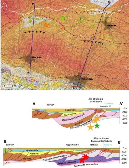
Fig. Geological map and geological sections throught Ferrara folds; stars indicate the ipocentres.The epicentres of the Emilia earthquakes of 2012 are located above the central sector of the so-called “Ferrara Folds”.
In scientific literature, this term is used to indicate a group of folds resembling a corrugation of the rocky substrate, which together form an arc extending approximately from Reggio Emilia to Ravenna, passing right under the city of Ferrara.
These folds were produced by thrust faults, which are faults where rocks are pushed up and over other strata; this overthrust of rocks takes place along detachment horizons, which generally correspond to a succession of strata that are more plastic than both underlying and overlying rocks.
The “Ferrara Folds” led to the formation of two main ridges: an internal ridge, culminating roughly between Novi di Modena and Mirandola (province of Modena), and an external ridge that culminates between Bondeno (province of Ferrara) and Occhiobello (province of Rovigo).These ridges constitute one of the leading thrust fronts of the Apennine chain overlaying the non-deformed foreland, the so-called Lombard-Veneto platform.The main detachment horizon along which relative movement of rock masses occurs, consists of Triassic evaporites that form the base of the Meso-Cenozoic sedimentary succession (dating back to 250-150 million years ago) overlaying an earlier metamorphic basement.The hypocentres of the main shocks of the sequence that began on 20th May all appear to be localized in this stratigraphic interval.
The Emilia earthquakes of May 2012 corroborated existing knowledge regarding the kinematic interaction of these structures.This knowledge is summed up briefly in the ZS9 seismogenic zonation (zone 912, v. Meletti & Valensise, 2004) and documented in the database of individual seismogenic sources (DISS Working Group, 2010).
The documented effects also confirmed the territory’s susceptibility to site effects and liquefaction.
Site effects
Peak ground acceleration values recorded during the May 2012 earthquakes in Emilia were rather high in some areas, in some cases over 20% the acceleration of gravity.
Based on the Italian seismic hazard map, expected ground acceleration in these areas is in the region of 15% the acceleration of gravity.The increased shaking recorded above ground, compared to the levels previously forecast, can be attributed to local subsoil characteristics.
Studies which analyzed ground behaviour during the earthquakes indicate that there are a number of factors that favour site effects.These factors are linked to local lithological and geomorphological characteristics. In particular, loose and poorly consolidated terrains such as recent alluvial sediment, lacustrine and marine deposits, predominantly clayey (and also highly fractured or altered rock units, detritus accumulations) and particular landforms (isolated peaks, elongated ridges and summits, …) can change seismic ground motion, namely the propagation of seismic waves upwards, amplifying the extent and duration of shaking.
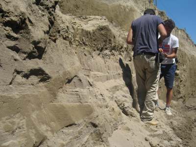
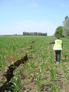
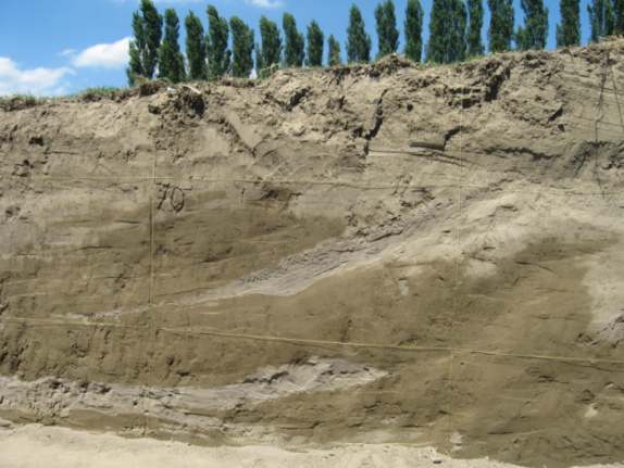
The subsoil of the areas hit by the earthquakes of May 2012 is comprised of tens of metres of clayey and sandy alluvial sediment which, in geological terms, is very young and therefore poorly consolidated; this provides the conditions for increased shaking at ground level, also recorded with high-tech instrumentation.The increased shaking in the upper portion of the subsoil is also one of the causes of the most striking environmental phenomena observed, namely liquefaction, as sand and silt surfaced from wells, small craters and fractures in the ground, extending for tens of metres in some cases, immediately after the main shocks of 20th and 29th May.
Liquefaction
The term liquefaction is used to indicate various physical phenomena (cyclic mobility, cyclic liquefaction, flow liquefaction) observed in saturated sandy deposits during strong earthquakes (magnitude >above 5.5).Liquefaction occurs when certain predisposing conditions coincide with a triggering event.
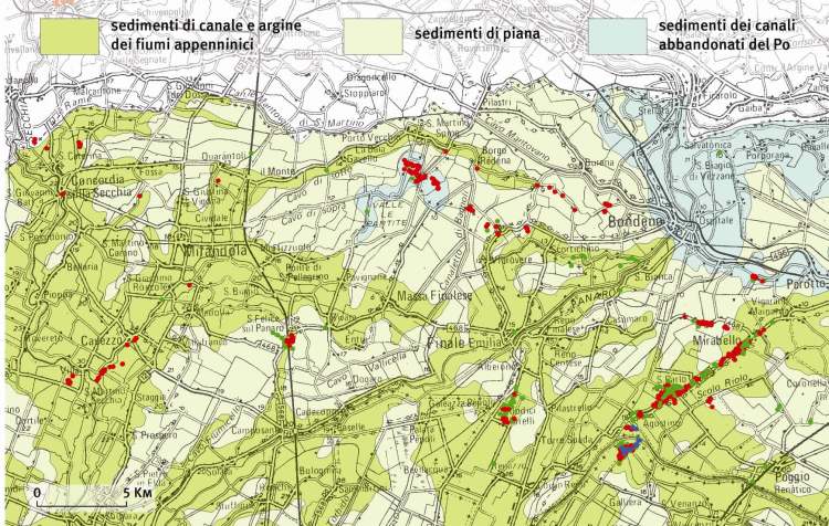
Fig. 5 Distribution of liquefaction phenomena (points in red and green) - ENLARGE MAP (JPEG - 141,3 KB)
Predisposing factors:
- uncemented and loose sand at a depth of less than15-20 m;
- depth of water table less than 15 m;
- size of grains of sand from 0.02 mm to 2 mm;
- fine sediment content (with grain diameter below 0.05 mm) less than 15%;
Triggering event:
- earthquake of a magnitude above 5.5;
- ground acceleration 15% that of gravity (g);
- duration of shaking at least 15-20 seconds.
Unfortunately, in various areas of the Po Plain and along certain stretches of the Adriatic coast, predisposing factors are common and the earthquakes of 20th and 29th May released the energy required to trigger the phenomenon of liquefaction.
Incidences of liquefaction had already been described in relation to various earthquakes, including several major shocks that hit Emilia-Romagna (Ferrara 1570, Argenta 1624, Cesenatico <0}{0>1875, Rimini 1916).<}0{>1875, Rimini 1916). Also during the Aquila earthquake of 6/4/2009, liquefaction was observed (De Martini et al., 2012), but fortunately it remained purely of scientific interest given that it occurred away from built-up areas and caused no damage to buildings. A particular characteristic of the Emilia earthquakes of May 2012, on the other hand, was widespread liquefaction in urbanized areas too, which incurred enormous damage.
The liquefaction was particularly serious in the urban areas of S. Carlo, a hamlet of S. Agostino, and in Mirabello, in the province of Ferrara, where secondary effects subsequent to the liquefaction made several buildings, stretches of road and utility networks temporarily unsafe for use.
In order to conduct an in-depth assessment of these effects and verify the stability and safety of buildings, highways and the utility networks declared temporarily unsafe in S. Carlo and Mirabello, Emilia-Romagna regional authority and the Department of Civil Protection set up an interdisciplinary working group that included geologists, geotechnicians and structural engineers. The group’s findings are published on the website of the Geological, Seismic and Soil Survey.
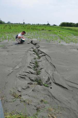
In summary, the main effects observed on the ground were the formation of sand boils, craters, bulges and cracks in the ground, subsidence, uplifting of pavements and lateral spreading.
These effects, caused by the liquefaction of sandy facies in the subsoil, were observed in various areas in correspondence to abandoned river channels.
The level of damage to civil buildings in the areas affected by liquefaction varied, however on the whole it was lower than might have been expected given the number and geographical spread of the phenomenon and the large volume of sand and silt that surfaced.
Some buildings suffered rigid translation settlements, in some cases with a slight rotational component. Joint shear failure occurred in minor and structurally weak buildings (garages, sheds and tool sheds) connected to main buildings. In many cases these secondary constructions suffered serious damage and were left unsafe. There was widespread damage to ground floor paving, partition walls and mains water connections, but less damage to strong, well-built vertical and horizontal structures.
Fortunately, there were no cases of flow liquefaction, which commonly leads to a loss of load bearing capacity resulting in serious instability sinking and/or toppling of heavy buildings, floating of underground tanks).