The seismic microzonation
a well-established tool for urban planning and seismic risk reduction in Emilia-Romagna
Approximately 75% of the regional territory comprises areas susceptible to site effects in the event of an earthquake. Given this situation, it is therefore clear how important seismic microzonation is for the mitigation of seismic risk.
In Emilia-Romagna, attention to prevention and mitigation of risk, including seismic risk, is manifest in the body of regional legislation since 1978.
However, it was only following the Ministerial Decree of 14/09/05 and the coming into force of the Prime Ministerial Decree n. 3274/2003, that in 2007 the Region approved “Guidelines for seismic microzonation studies in Emilia-Romagna to support territorial and urban planning” (DAL 112/2007).
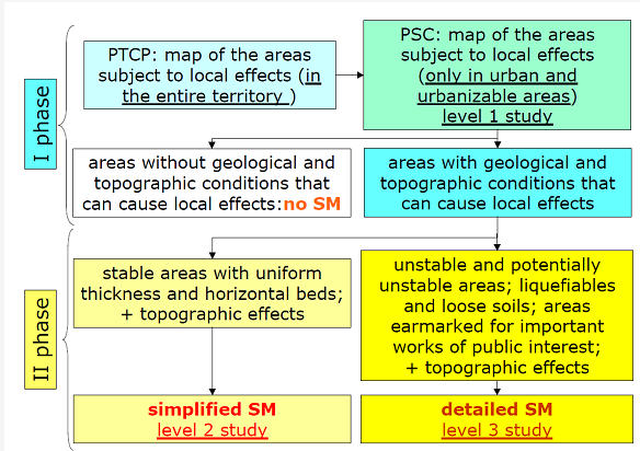
These guidelines establish criteria and operational instructions for the identification of areas subject to site effects and for seismic microzonation, in order to guide planning towards areas with lower seismic risk. Based on the criteria proposed, seismic microzonation studies prescribe two distinct phases of analysis and three levels of investigation, depending on the aims and final uses as well as the local risk scenarios (Fig. 1).
The first phase coincides with the first level of investigation and its purpose is to establish local seismic hazard scenarios, identifying areas subject to site effects.
The second phase is limited to areas already urbanized or designated as susceptible to urbanization where they fall within areas identified in phase one as subject to site effects. It is in this phase that seismic microzonation of the study area is carried out. On the basis of the scenarios identified in phase one, two different levels of investigation apply (level 2 or 3) characterized by different programmes of investigation depending on the local geological and morphological characteristics.

Figure 1 – Flow diagram of the seismic microzonation (SM) studies in Emilia-Romagna, according to regional guidelines (DAL 112/2007).
In order to implement the above-mentioned policies and strategies, it is essential to have suitable topographic and geological maps which enable to identify elements of natural hazard present.
For the entire regional territory, maps and geological maps at various scales, also in digital format (GIS) are now available. A digital terrain model (DTM) is also available, with definition up to 5 m x 5 m. For more in-depth investigations (levels 2 and 3) it is equally important to establish regional databases for the stratigraphic and geotechnical characterization of deposits based on the results of drillings and available in-situ and laboratory tests. In particular, for the geological map of the plain and coastal areas, the Region’s Geological Survey carried out numerous bore-hole drillings and penetration tests in addition to gathering existing data. All the data was organized in a geo-referenced database which today comprises over 60,000 stratigraphic logs from bore-holes, oil- and water-wells and penetration tests.
In the first 5 years following the introduction of the guidelines, the Region was able to create a good knowledge base on local seismic hazard.
All Provincial Authorities have carried outanalyses of areas susceptible to local effects and kind of expected effects throughout the entire territory (level 1 analysis at provincial scale).

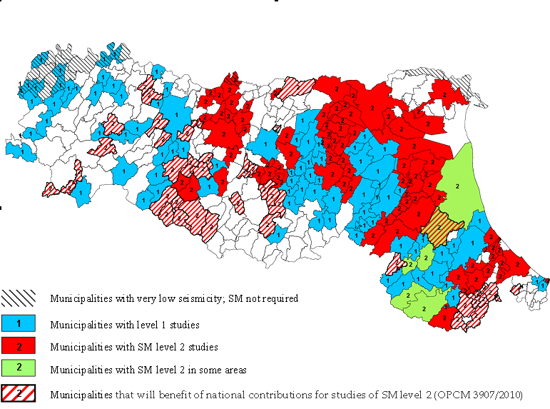
As regards seismic microzonation at municipal and sub-municipal scale (level 2 investigation) until now these studies have mostly been carried out in areas of greatest seismic risk (Romagna; Apennine-Po Plain margin, Apennine watershed), where awareness of the problems associated with it is also heightened (Fig. 2).
Figure 2 – Index map of the seismic microzonation (SM) studies in Emilia-Romagna.
New impulse to the study of seismic microzonation is derived from the National Law No 77/2009, see in particular article 11, establishing a fund for the prevention of seismic risk and provides for contributions to the Regions for studies of seismic microzonation. Thanks to these contributions, new seismic microzonation studies of second level in 39 municipalities in the Region are in progress. For the realization of these studies, the Emilia-Romagna Region defined specific criteria (DGR 1051/2011) also derived from the national addresses (Working Group SM, 2008) and from the experience of seismic microzonation of L’Aquila basin for the reconstruction after the 6/4/2009 earthquake (Working Group SM-AQ, 2010).
( EUREGEO2012, Bologna. Authors; L.Martelli and M.Romani)
