Organic pollutants in soil
Overview of background levels of some organic compounds (dioxins, furans, PAHs, PCBs) in the soils of the Emilia-Romagna plain
Dioxins and furans (PCDD/PCDFs), polychlorinated biphenyls (PCBs) and polycyclic aromatic hydrocarbons (PAHs) are organic pollutants that can persist in the environment and bioaccumulate, thus constituting a hazard to human health and the environment. These substances are organic compounds mostly of anthropogenic origin, characterised by high lipo-affinity, semi-volatile and resistant to degradation. These characteristics make them extremely persistent in the environment and capable of being transported over long distances.
These substances tend to bio-concentrate and exhibit a bio-magnification process, thus reaching potentially toxicologically relevant concentrations. Bio-magnification, i.e. the accumulation of increasing amounts from prey to predators, occurs via the alimentary route, most readily for decidedly lipophilic compounds and is most evident in terminal predators.
These organic pollutants are released into the environment from numerous sources, show some mobility between different environmental matrices, have a stable chemical structure and a considerable half-life. They can cause persistent, almost ubiquitous pollution and accumulate during particular events (ARPAV, 2016).
Since agricultural soils represent a particularly ‘intact’ whole, they can allow the definition of reference values against which to compare situations subjected to greater impact (urban soils, industrial areas, areas near incinerators and/or cement plants, etc.) in compliance with national legislation (Legislative Decree no. 152/2006 as amended by Ministerial Decree 46/19).
Since 2017, the Geology, Soils and Seismic Area has launched, in collaboration with the Energy, Waste and Contaminated Sites Observatory of the Regional Enviroment Agency (ARPAE), the project ‘Acquisition of a cognitive framework of the background levels of some organic compounds in the soils of the Emilia-Romagna plain’ aimed at acquiring and implementing knowledge on the quality of the soils of the regional plain, with specific reference to the content of dioxins, furans, PAHs, PCBs in the soils. The aim of the project is to identify reference values of organic micropollutants in agricultural soils, linked to diffuse sources of pollution as defined by the ISO19258:2018 standard, i.e:standard, i.e:
- atmospheric fallout;
- spreading of sludge, compost and other organic soil improvers;
- spreading of sediments from flooding or excavation of watercourses.
Given the close connection between air quality (also in terms of atmospheric dust content) and the content of organic micropollutants in the soil, in order to define the background content of the latter in agriculturalsoils, it was decided to survey the soils of areas close to rural stations of the ARPAE regional air monitoring network.
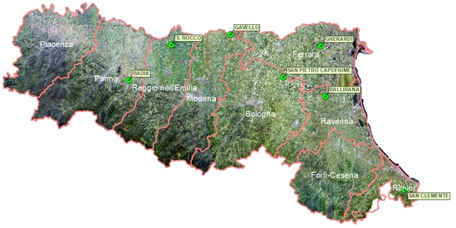
Figure 1. Rural stations of the air monitoring network investigated until 2023
The results from the sampling of six rural areas around the stations between 2017 and 2022 with ten samples each, both in the dry season (summer) and in the wet season (winter), were used as the data base. The samples were analysed by the ARPAE laboratory in Ravenna. The sampling data of 2023 (San Clemente area, considered representative also for the province of Forlì-Cesena) and 2024 (Besenzone area), have not yet been processed.
The chosen sites are in different soil landscape units of the plain and hills.
Groups | Sampling Area | Province | Sampling Year | Soil landscapes units (1:1.000.000) |
A | Molinella | Bologna | 2017 | A5, A6 |
B | Jolanda di Savoia | Ferrara | 2018 | A2 |
C | Guastalla | Reggio Emilia | 2019 | A5, A6 |
D | Alfonsine | Ravenna | 2020 | A5, A6 |
E | Langhirano | Parma | 2021 | A9, A7 |
F | Mirandola | Modena | 2022 | A5 |
G | San Clemente | Rimini | 2023 | B1, A7 |
H | Besenzone | Piacenza | 2024 | A5, A6 |
Table 1. List of sampling areas and soil types surveyed
Every group of organic compounds was statistically processed on three different levels:
- Level 1: Analysis of the entire dataset with only one level of clustering (typically, by CLASS or analyte);
- Level 2: Analysis of dataset by applying two levels of clustering (typically, by CLASS and then by one of the two main factors ‘Season’ or ‘Grouping’);
- Level 3: Analysis of dataset by applying three levels of clustering (typically, by CLASS and then the combination of the two main factors ‘Season’ and ‘Grouping’) in order to obtain the greatest possible meaningful detail of information.
As far as PAHs and PCBs are concerned, statistical processing shows that the values are so low that they are mostly below the limit of quantification (LoQ) and therefore there is no correlation with either soil type, geographical location or landform.
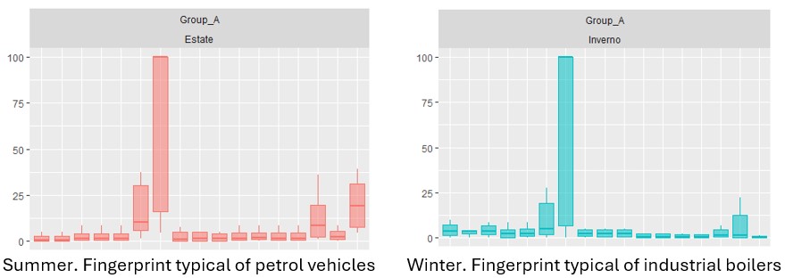
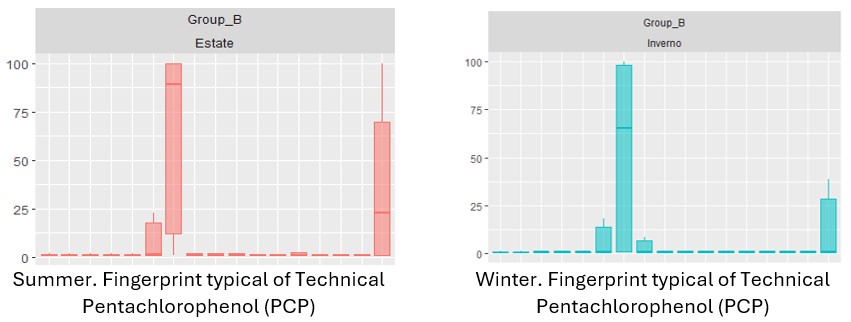
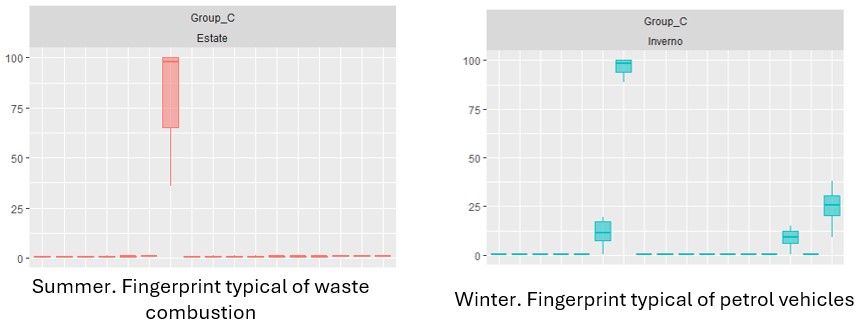
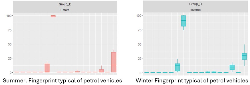
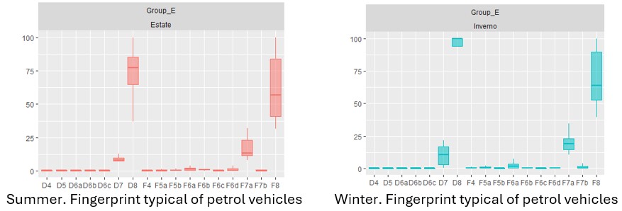
In the case of dioxins and furans (which are also far below the threshold values), an analysis was made of the distribution and relative abundance of the various congeners, as these are characteristic indicators of the specific process that originated them, and their fingerprints are documented in the literature.
From the analysis, three macro-groups emerge that are similar in terms of the distribution of dioxin content in the soil: one represented by sites A and B; one represented by groups D, E and F; and finally a further group represented by C, which is more similar to macro-group A/B than to macro-group D/E/F. It can therefore be said that the soil type is irrelevant with respect to the accumulation of these substances.
In further confirmation of this (figure 2), the footprints of the different groups in the different seasons were compared and a type of footprint of the congeners substantially linked to atmospheric fall-out and air pollution, a well-known characteristic of the Emilia-Romagna plains, was revealed.
An exception is group B in which the typical footprint is linked to pesticides used in agriculture; group C in summer shows a typical footprint from waste combustion; group A in winter of effects linked to boilers for industrial use.
A - Molinella (BO)
B - Jolanda di Savoia (FE)
C - Guastalla (RE)
D - Alfonsine (RA)
E - Langhirano (PR)
F - Mirandola (MO)
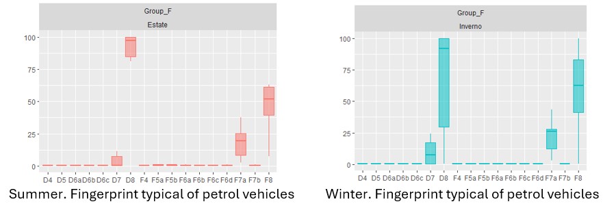
Figure 2. Identification of typical fingerprints of different groups in different seasons
Reports (italian language)
https://ambiente.regione.emilia-romagna.it/+051 5275431
