The cosatal system

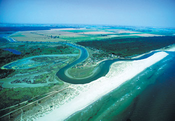
Emilia-Romagna lies on the Adriatic Sea with a low, sandy coastline which stretches for approximately 130 km from the Goro Po mouth to the Gabicce headland. The distinctive element of this coast is the beach, produced by the interaction, over a long period of time, between sediment carried to the sea by rivers, redistribution and deposition by the waves and marine currents and the modelling action of the wind.
From the southern boundary of the region to the Volano Po, the beach is interrupted only by ports and river outlets. In some parts the beach is over 200 metres wide, while in other parts it is completely eroded and has been replaced by sea-walls.
The morphology of the northern coastline, lying between the border with Veneto region and the Volano Po mouth, is closely linked to the dynamics of the Po river and the action of the Bora winds, which blow from east-north-east. In this area the beach lies offshore, forming a sand bar called spit that separates the open sea from the area behind which is characterised by lagoons of brackish water, locally referred to as sacs.
Behind the coastal system are vast reclaimed areas, which lie below sea level, consisting partly of wetlands (Bertuzzi Valley, Comacchio Valleys, Piallasse di Ravenna) which are home to natural eco-systems of inestimable value.
In addition to this great naturalistic heritage, the Emilia-Romagna coast offers precious historical testimony, is one of Europe’s most popular destinations and also supports a number of industrial and manufacturing concerns. Human activity has drastically interfered with the natural evolution of the coast, making this territory extremely vulnerable. Over the past fifty years the area has been highly urbanized, beachfront bathing establishments, ports, wharfs and coastal defence systems (breakwaters and piers) have been built, altering the morphodynamic characteristics of the beach.
There are increasingly fewer areas today where it is possible to observe typical beach morphology with sandy dunes behind the beach, or a river outlet unconfined by man-made banks.
Improved knowledge of this environment, and the safeguarding of production activities are key themes which Emilia-Romagna Region has included in its territorial defence strategy.
Publications
- THE SEA… instructions for use - version 2.2
- Coast and Sea
- The coast, a territory we must get to know and defend
- Impact of storms along the coastline of Emilia-Romagna: the morphological signature on the Ravenna coastline (Italy)
- Evaluation of maximum storm wave run-up and surges along the Emilia-Romagna coastline (NE Italy): A step towards a risk zonation in support of local CZM strategies
- Article on "Integrated Coastal Zone Management (ICZM) - The Global Challenge (PDF - 2,4 MB)
- Photo gallery -The coast of Emilia-Romagna
Geological, soil and seismic risk area
The testing phase of the system is one of the pilot actions of the European Project SHAPE and will be completed during the future nourishment projects .
