Physical-hydrological properties of soils
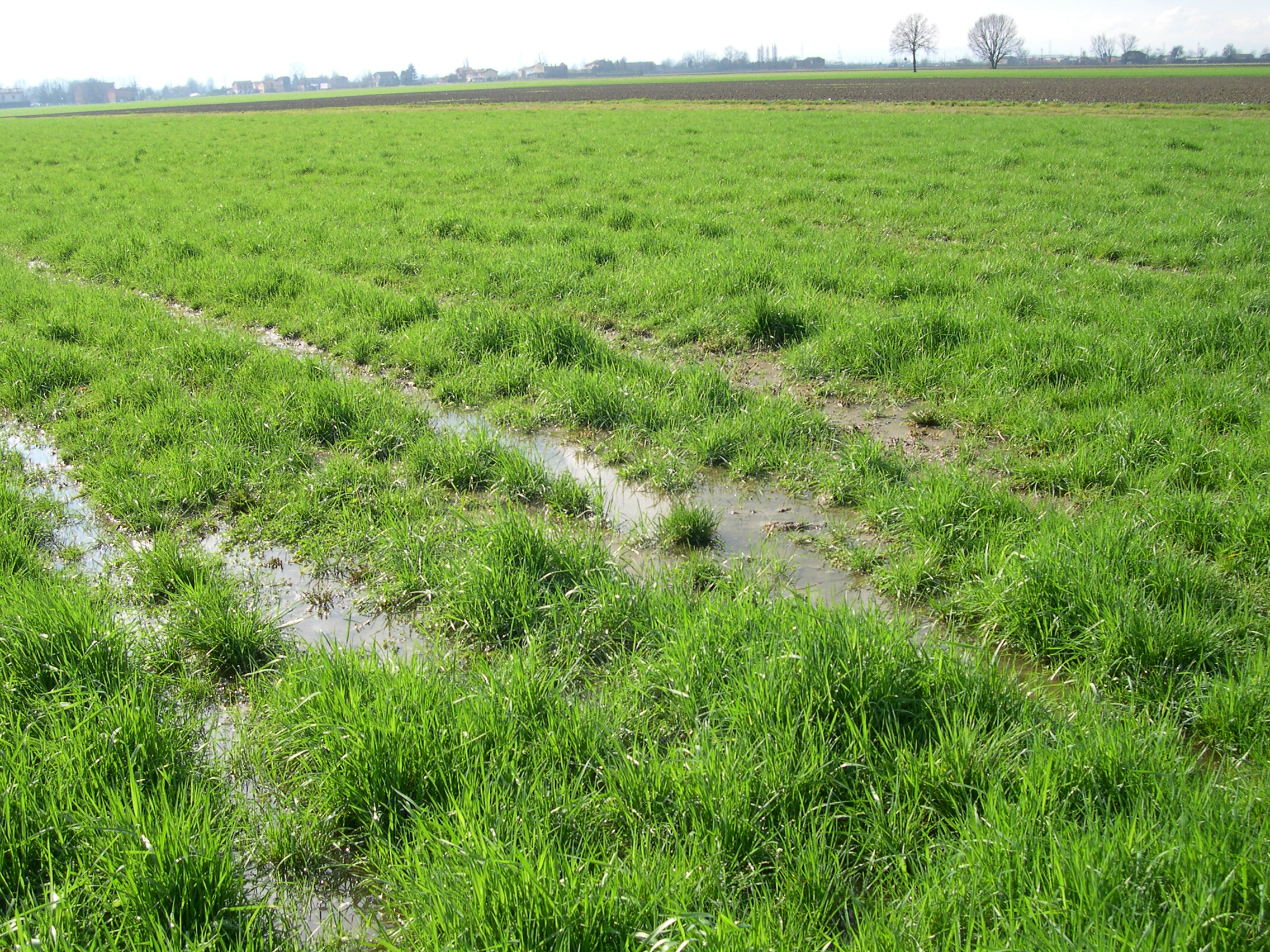
The amount of water, air and nutrients available for plant growth is influenced by the soil physical and hydrological properties and by management practices.
The physical-hydrological soil parameters are required as input data in different models commonly used to make predictions, estimates and assessments of the phenomena that affect the movement of water in the soil/groundwater/surface stream system. They also serve as a yardstick for environmental assessments in relation to the filtering function performed by soils for contaminants to groundwater.
The main soil physical and hydrological properties are:
- Texture
- Structure
- Saturated hydraulic conductivity (Ksat)
- Consistence
- Bulk density
- Available water capacity (AWC)
Texture
The particles that compose the soil can be divided by size categories. There is a great variability in the particle size: coarser particles (>2mm in diameter) form the skeleton, whereas the finer ones form the fine earth.
The fine earth fraction is further divided in sand (0.05 mm - 2 mm in diameter), silt (0.002 mm - 0.05 mm in diameter) and clay (<0.002 mm in diameter).
Texture indicates the relative content of fine earth particles. Emilia-Romagna region follows the classification system according to Soil Survey Division Staff, 1993.
Different combinations of sand, silt and clay are grouped in textural classes.
Texture affects the chemical and physical behaviour of soils. Texture is important for engineering and agronomic interpretations, influences the hydrological qualities of soil and is used for soil classification. Main soil properties affected by texture are drainage, water holding capacity, soil aeration, susceptibility to erosion and cation exchange capacity.
Structure
Structure is the arrangement of the grain-size particles into aggregates which have easily distinguishable shapes. The aggregates can have laminar, granular, angular or prismatic form or soil may be structureless (single sand graines or shapeless resistant masses).
Structure is formed by the continuous alternation of freezing/thawing, in the transition from the wet state to the dry one, by microorganisms activity and root pressure and through cementing by clay, organic matter, iron and aluminum compounds.
Structure increases infiltration of water, thus reducing runoff and erosion, increases the amount of plant available water; improves seedling emergence, root growth and rooting depth and increases permeability because of large continuous pore presence.
Saturated hydraulic conductivity (Ksat)
Saturated hydraulic conductivity (Ksat) refers to the ability of a soil to transmit water when a soil is fully saturated. It’s expressed as cm of water/hour and depends on the properties of both porosity (pore geometry) that the fluid (stickiness and density).
If Ksat is high the water moves fast, if low water moves slowly. Ksat is a parameter used to describe hydrological behaviour of soils such as permeability, infiltration, water balance and hydrological soil groups. Hydrological soil groups gather together soils with similar physical and runoff characteristics.
The factors that affect Ksat are:
Texture: pores size decreases with smaller particles size: as a result fine textured soils are less permeable;
Organic matter increases aggregates stability;
Structure is related to pore continuity. A well-structured soil is more permeable than a poor-structured one;
Root and worm channels;
Pores size and continuity: the more pores are large and continuous the more water moves quickly.
Consistence
Consistence describes the resistance of a soil, at different moisture content, to mechanical stress or handling. It expresses cohesive and adhesive forces holding soil particles together: plasticity and stickiness. Consistence is an indicator of the tendency of a soil to develop compacted zones, crusts, cemented layers that create issues of water stagnation, seedling emergence and root growth.
The main factors that affect consistence are water content, texture, type and amount of clay and soil density.
Bulk density
Density is the soil mass per unit volume and is expressed as g/cm3. Soil bulk or dry density is the ratio of the mass of the solid phase of the soil to its total volume (solid and pore volumes together), whereas soil particle density considers only the volume of the solid phase of the soil. Bulk density is always lower that particle density and can change considerably depending on texture, water content and structure.
This parameter affects engineering applications and plant growth. It is used to compute shrinkage/swelling potential, available water capacity, total porosity and also saturated hydraulic conductivity. It is used to convert measurements from a weight basis to a volume basis (e.g. transformation of organic carbon content from percentage to Mg/ha). It is an indicator of how well plant roots are able to extend into the soil.
Available water capacity (AWC)
Available water capacity is the volume of water that should be available to plants if the soil were at field capacity. It is expressed in cm of water for each soil horizon or layer and it’s the difference between field capacity and permanent wilting point water contents. AWC is an important factor in the choice and management of irrigation systems, drainage systems, to predict water resources for a better choice of agricultural crops and also to predict yields.
It depends on organic matter content, soil texture, bulk density and soil structure.
Available Maps
With regard to texture (sand, silt, clay, coarse fragments, USDA texture class) and bulk density, new maps for the 0-30 cm layer were produced in 2023, in collaboration with CNR-IBE in Florence, Italy, over the entire regional territory, with the exception of the two Marecchia Valley municipalities that joined the region in 2021. The new maps (in raster format) have a level of detail of 1 ha (100m x 100m pixels).
Two 1:50.00 scale maps are also available, relative to the alluvial plain, for the parameters saturated hydraulic conductivity (Field Book for Describing and Sampling Soils, 2012) and hydrologic groups of soils (National Engineering Handbook USDA-NRCS, 2009 (PDF - 123.4 KB)).
Bulk Density parameter is available in other documents such as:
Bulk density map in the 0-30cm layer: raster file in the SOC stock package (download from Minerva site);
Soil Catalogue : the soil genetic horizons section contains, among other parameters, data on bulk density (for the the soils of the plain only);
Benchmark local sites: bulk density and Ksat values, derived mostly by pedotransfer functions, are always present.
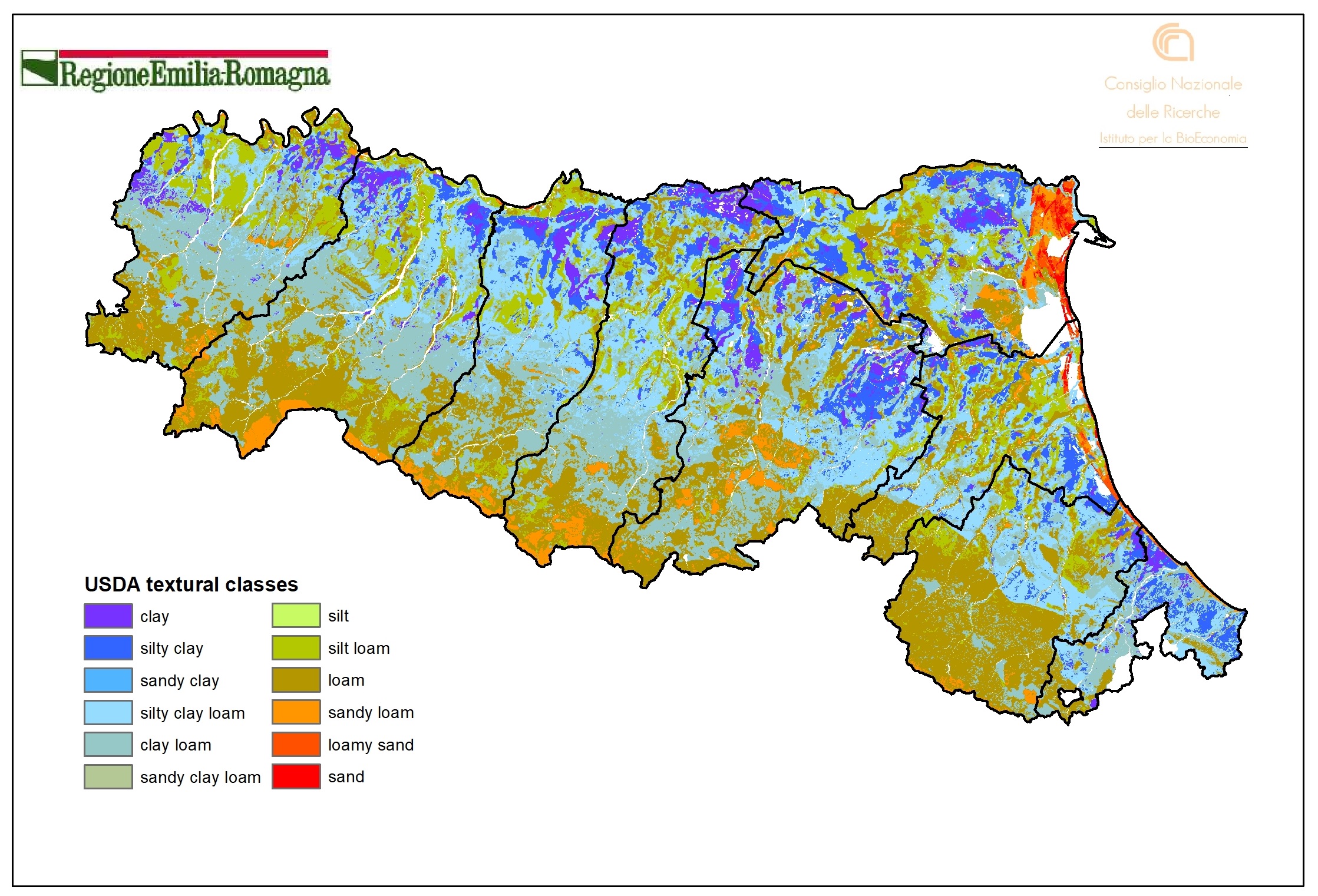
USDA textural classes - 0-30 cm layer (2023). Raster layer (pixel 100mx100m). DOWNLOAD
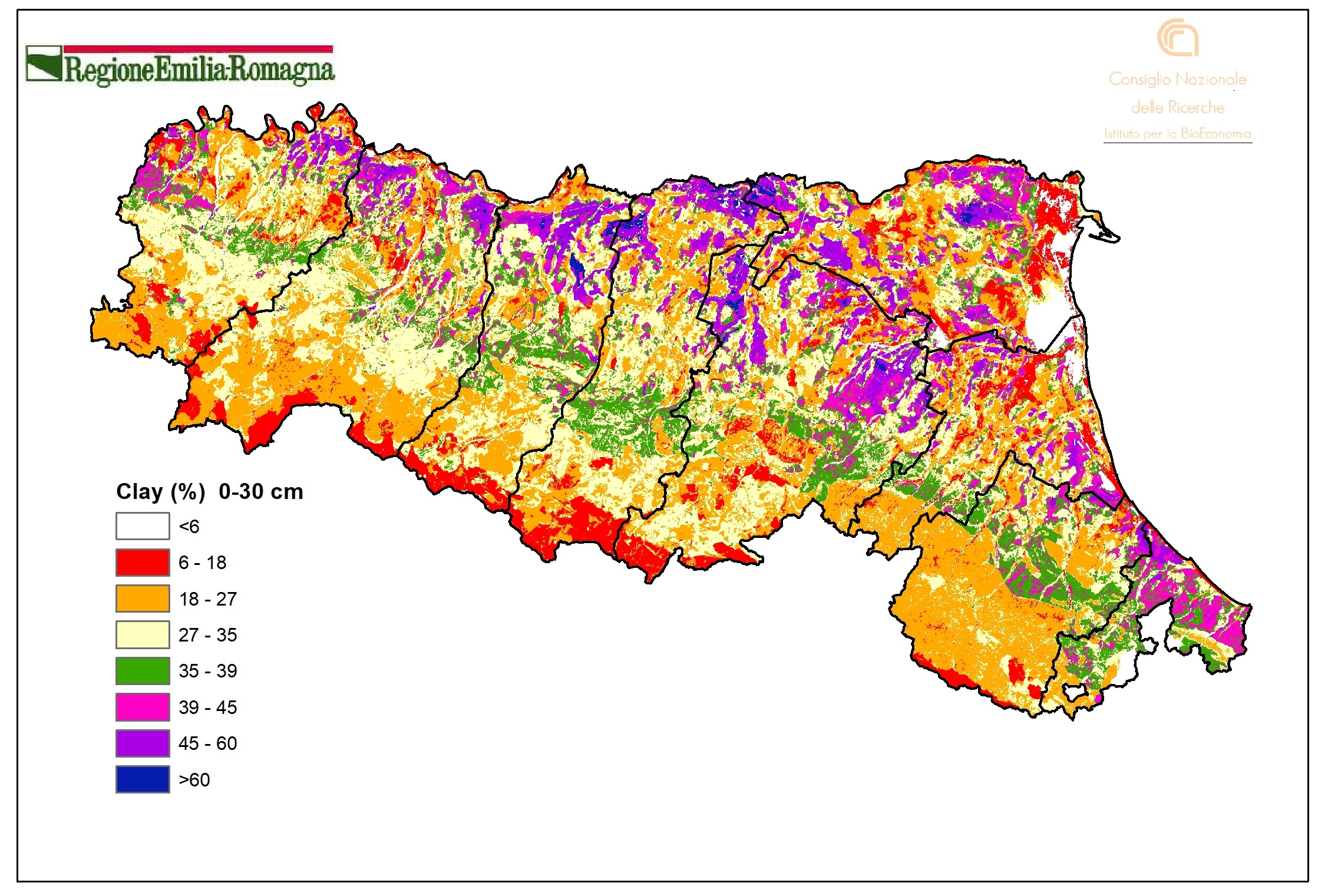
Clay content (%) - 0-30 cm layer (2023). Raster layer (pixel 100mx100m). DOWNLOAD
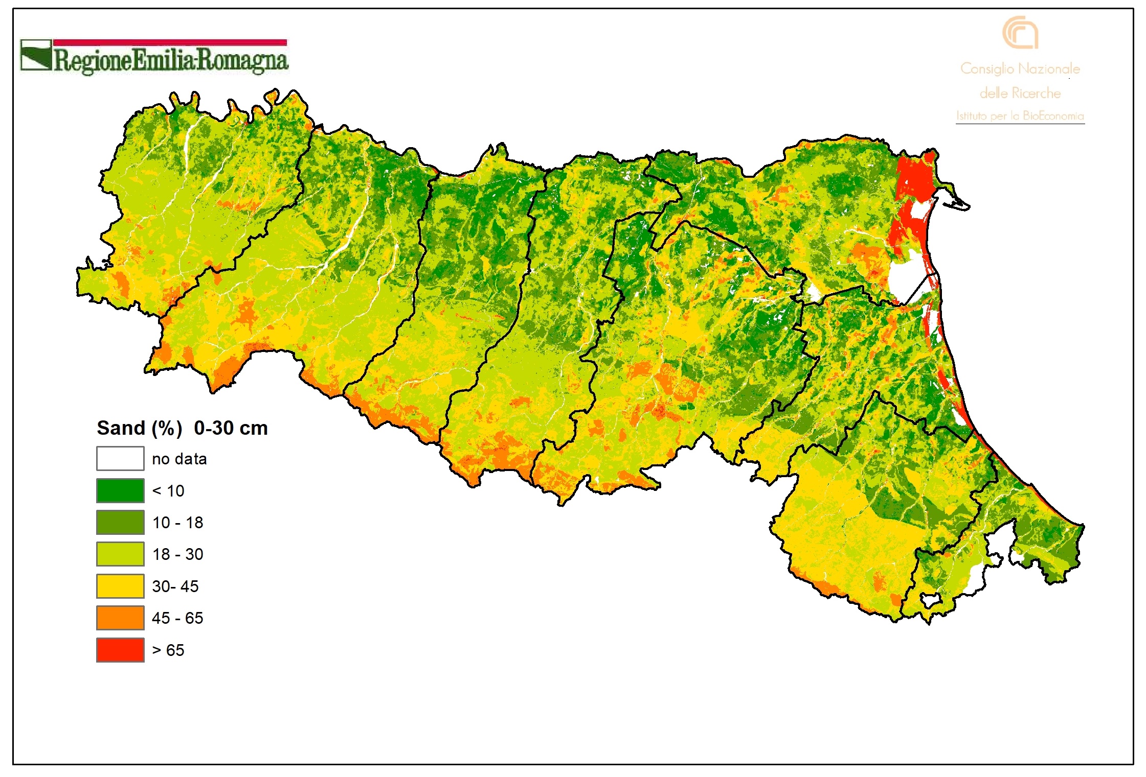
Sand content (%) - 0-30 cm layer (2023). Raster layer (pixel 100mx100m). DOWNLOAD
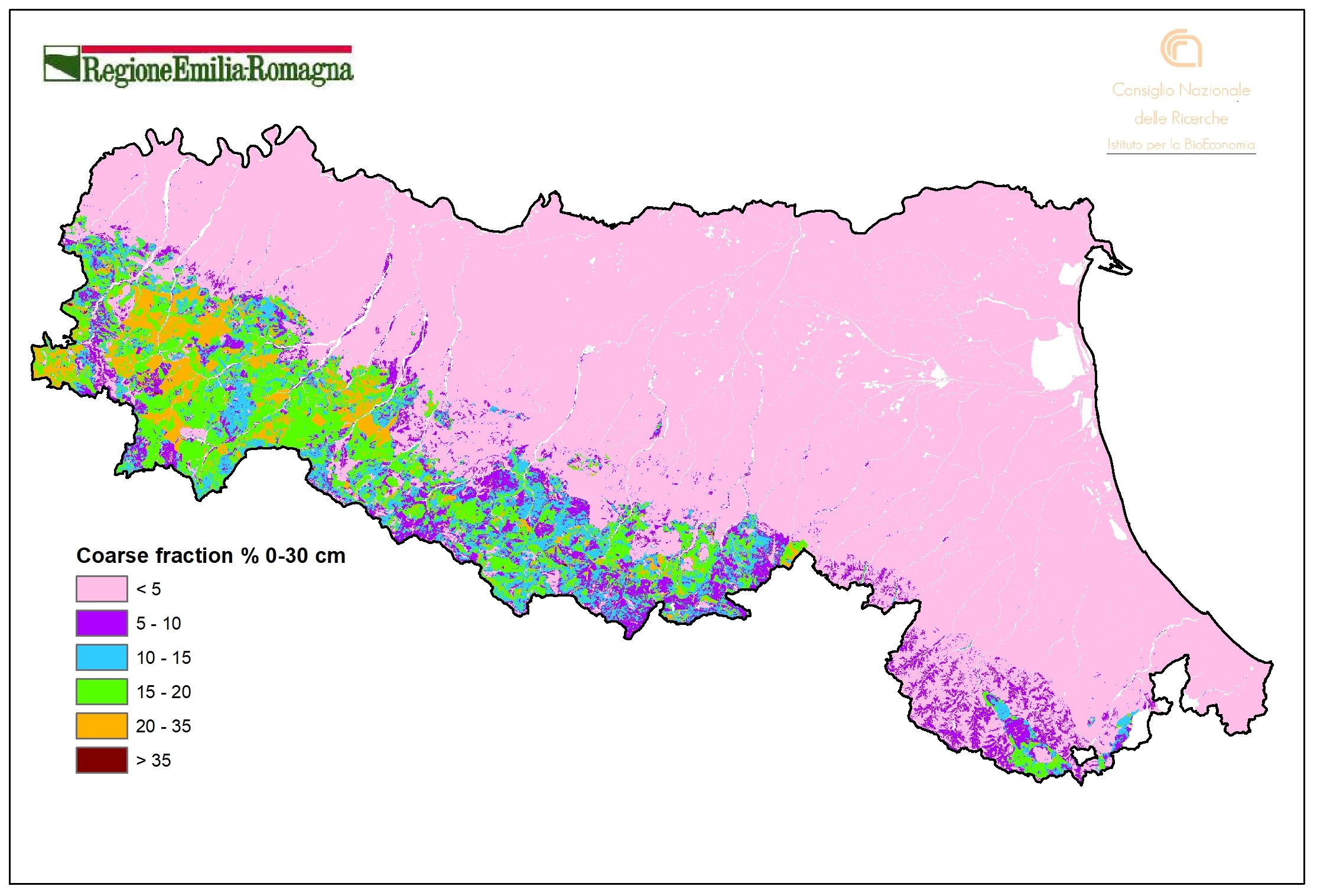
Coarse fragment content (%) - 0-30 cm layer (2023). Raster layer (pixel 100mx100m). DOWNLOAD
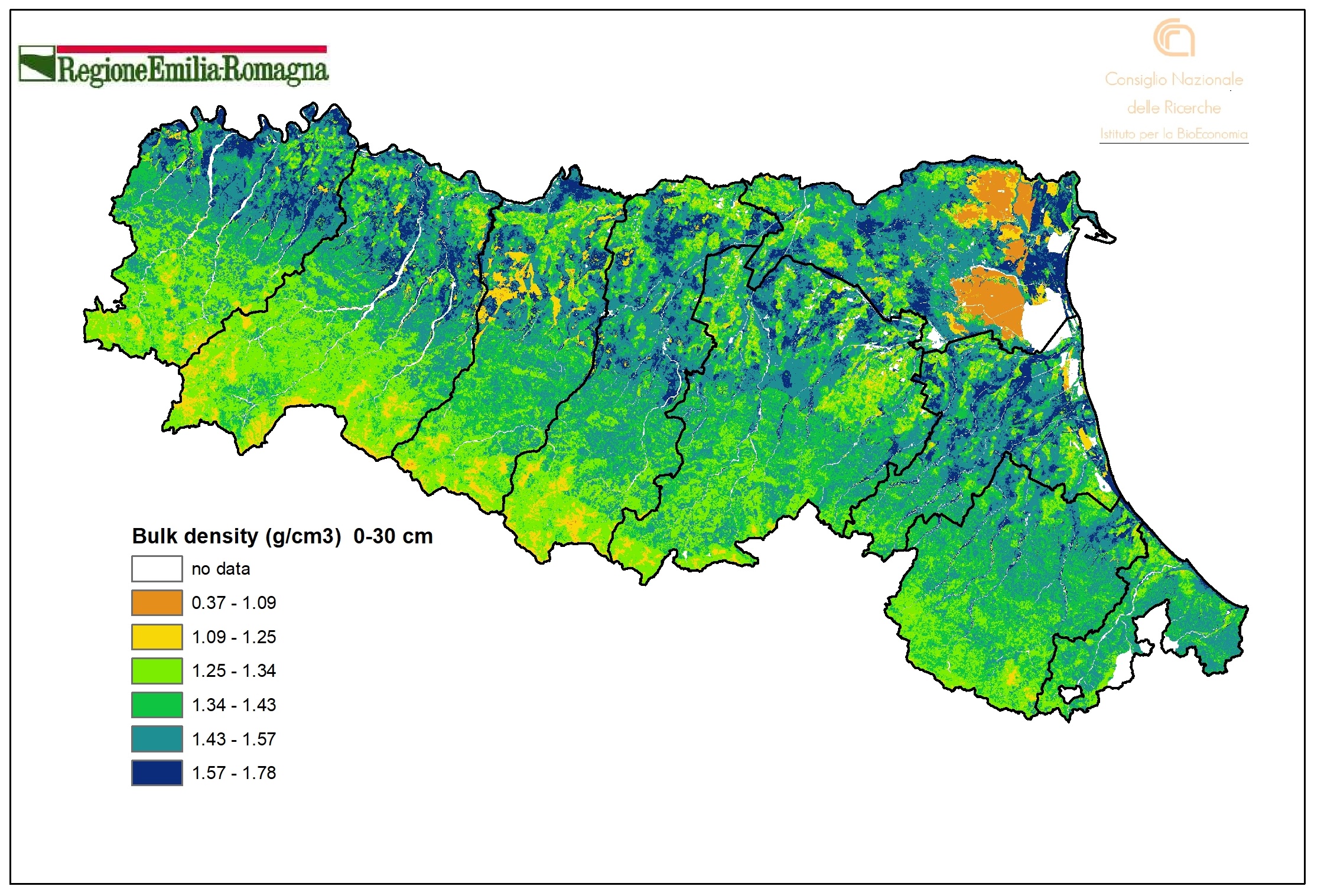
Bulk density (g/cm3) -0-30 cm layer (2023). Raster layer (pixel 100mx100m). DOWNLOAD
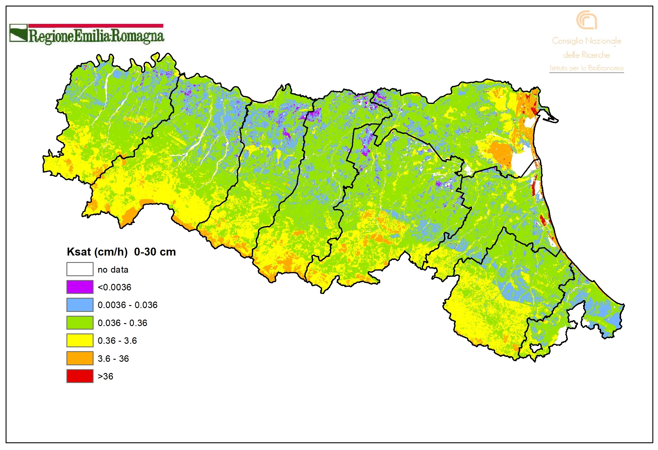
Ksat (cm/h) - 0-30 cm layer (2023)
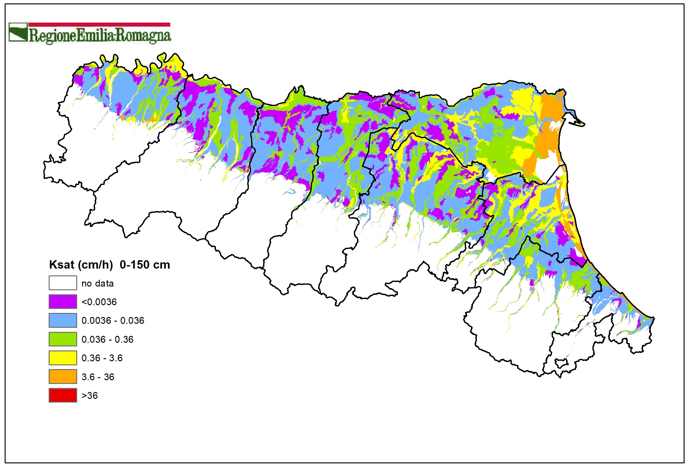
Ksat (cm/h) - 0-150 cm layer (2018). Vector layer. DOWNLOAD
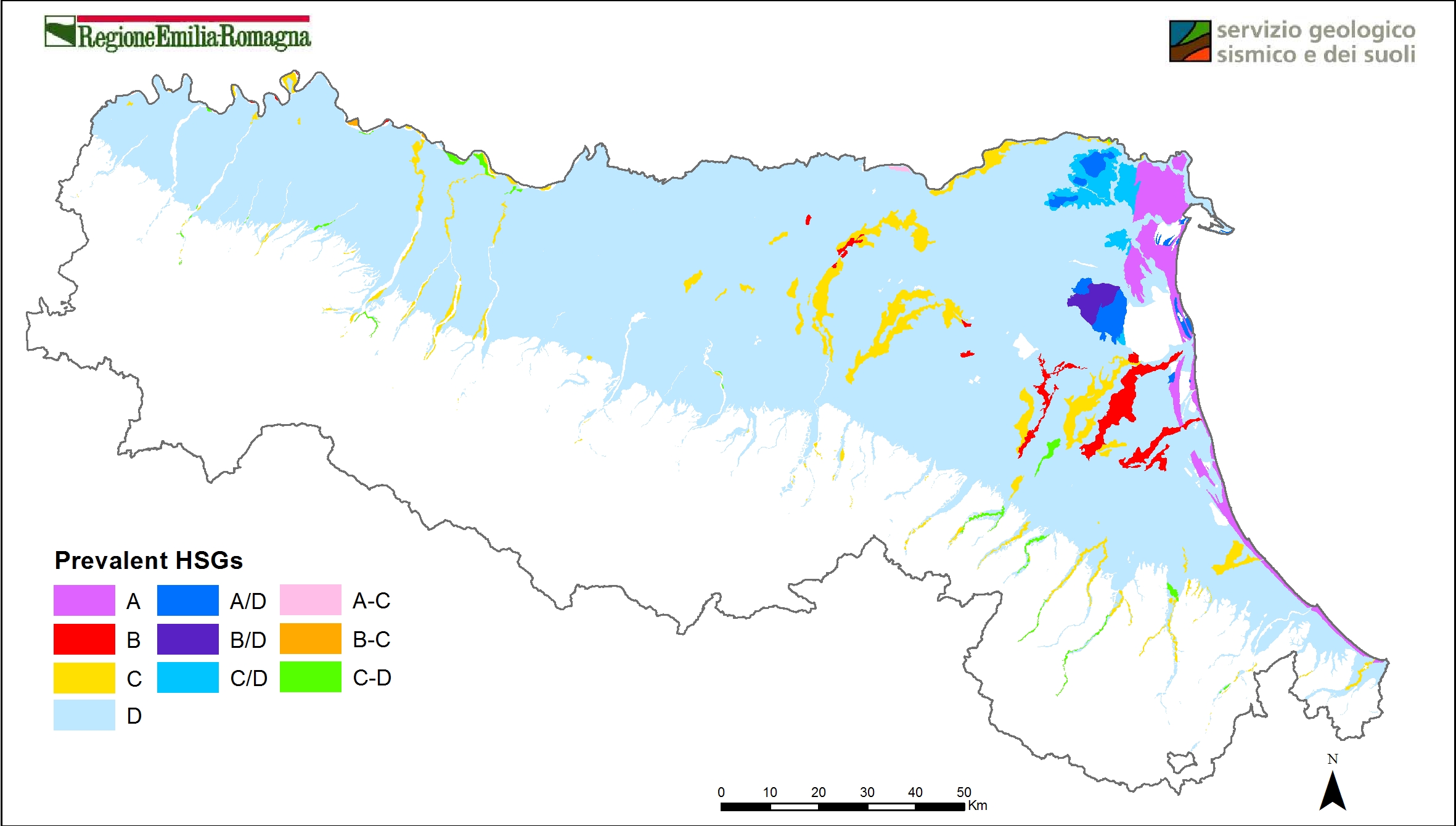
Hydrologic groups of soils (2014). Vector layer. DOWNLOAD
Web mapping
- Soil Catalogue of Emilia-Romagna The website provides access to 1:50k soil map and point data (extension service soil analyses and shallow water table measurement sites). A selection of derived thematic maps is available as well. It’s possible to draw plots, identify a soil type via an application wizard and calculate fertilisation plans. It is especially aimed at users in the agricoltural sector.
- Soil maps of Emilia-Romagna. It is a webgis site that contains all published maps since 2010 (soils maps and derived maps), as well as some point layers (Extension Service soil analyses, heavy metal analyses, shallow groundwater network stations). It allows simultaneous consultation of multiple layers. Many aerial/satellite images from 1954 to 2023 are available. It is especially aimed at users in the environmental and educational sectors.
- Soils of Emilia-Romagna. It is an easy-to-use site that describes the main features of the region's soils and landscapes. Through Google Earth, it makes available the maps of Emilia-Romagna soils at different scales (from scale 1:1,000,000 up to maps of farm soils). In the "Thematic Maps" section, it is also possible to consult application maps (e.g., use capacity, natural anthropic background of heavy metals) and maps of the chemical-physical properties of soils (e.g., organic C content, natural background of heavy metals, texture, pH, salinity).
- Minerva Portal It's possible to query and download metadata and data in open data format (shapefiles, TIFF, CSV and TXT table.
Contact us