Macronutrients (N, P, K)
Fertility factors can be physical, biological and chemical in nature; in particular, chemical fertility is the result of the availability and assimilability of mineral elements that plants absorb from the soil. For agriculture soil is a primary production factor whose chemical and physical characteristics and macronutrient content need to be known. The maps of the three main macronutrients (N, K, P) in the soils of the Emilia-Romagna region-layer 0-30 cm-represent a useful set of information for assessing the fertility of regional soils. Using this information, it is possible to prepare a fertilization plan adapted to the needs of plants, avoiding nutrient leaching phenomena that cause a waste of resources and often environmental damage.
Three sets of maps for the elements Nitrogen (N), Phosphorus (P) and Potassium (K) in regional soils for the 0-30 cm layer were produced in 2024, in collaboration with CNR-IBE in Florence. The maps cover the entire regional territory, with the exception of the two Marecchia Valley municipalities that joined the region in 2021. The new maps (in raster format) have a level of detail of 1 ha (100m x 100m pixels). They are downloadable from the minERva website; P and K maps are also available as P2O5 and K2O.

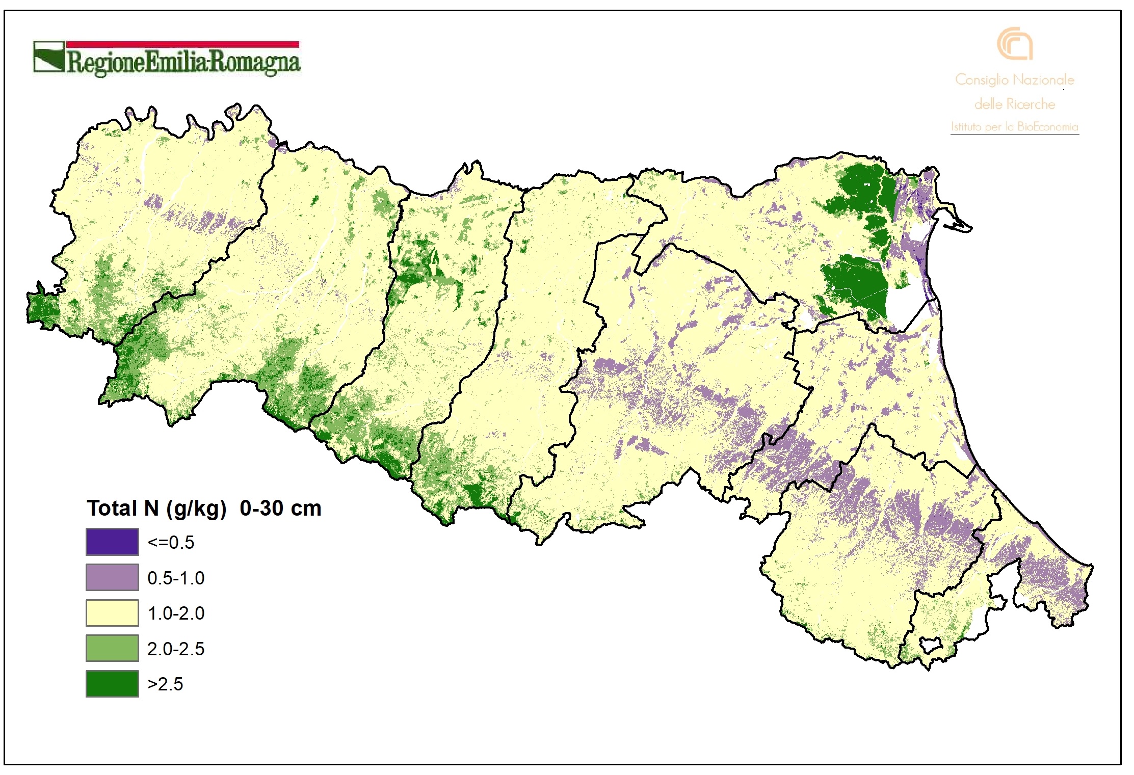
Figure1. Total nitrogen content map (g/kg). Classes of N according to the tables of the Integrated Pest Management Disciplines of the Emilia-Romagna region. Raster layer (pixel 100mx100m). DOWNLOAD
Regional soils have a total Nitrogen content of 1-2 mg/kg in most areas. They are N-deficient in much of the Romagna hills and the coast, while the content is very high in the organic soils of the Po delta and in the soils of the Upper Apennines. This distribution largely follows that of organic carbon content, to which Nitrogen is highly correlated. The average N content is about 1.6 ±0.7 g/kg.

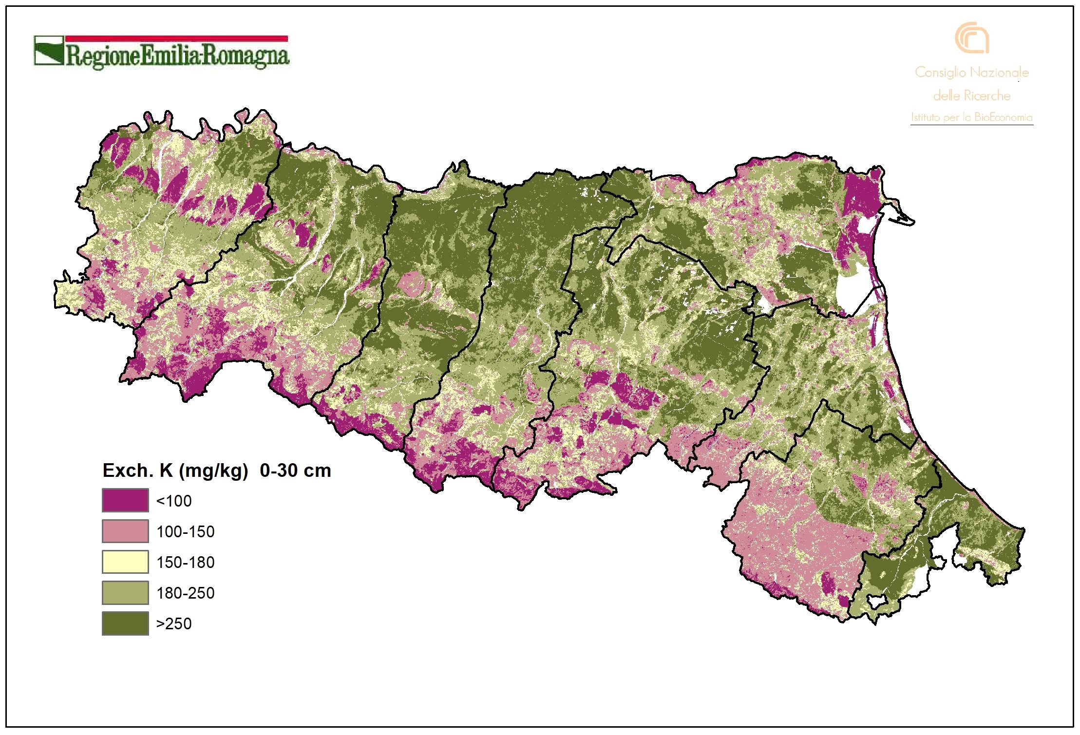
Figure 2. Exchangeable Potassium content map (mg/kg). Raster layer (pixel 100mx100m). DOWNLOAD
Exchangeable Potassium content is almost everywhere high; it is average in the Middle and Upper Apennines and is low locally, particularly on the soils of the Apennine Margin (Alfisols). The most influential factor was found to be the clay content, so it is not coincidental that the coarser (coast, Upper Apennines and Middle Apennine arenaceous soils) or siltier (Apennine Margin, Romagna Apennines) soils, both of which have low clay values, are the most potassium deficient. The average value of K in the Apennines is lower than in the alluvial plain, but in both cases there is strong variability. The regional average value is about 204 ± 73 mg/kg.

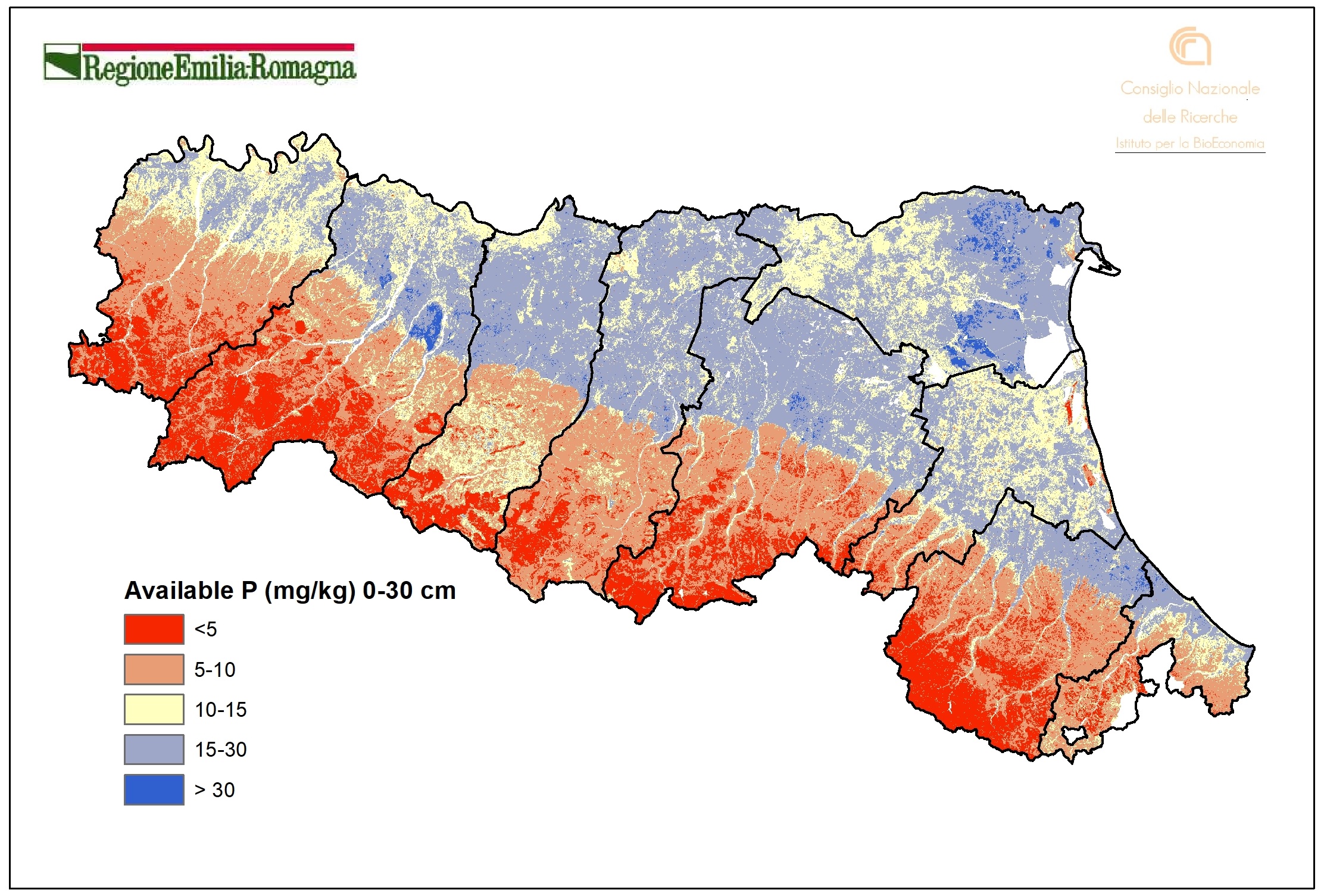
Figure 3. Available Phosphorus content map (mg/kg). Classes of P according to the tables of the Integrated Pest Management Disciplines of the Emilia-Romagna region. Raster layer (pixel 100mx100m). DOWNLOAD
The distribution of Available Phosphorus, according to the Olsen method, is clearly different between the alluvial plain and the Apennines, such that the average value at the regional level (12.28 mg/kg) is not significant. The mean values, in fact, in the two environments settle on very different values between them: 17.7 ± 4.8 mg/kg in the alluvial plain, while in the Apennines the value drops to 6.7 ± 2.6 mg/kg. Since regional soils are not naturally rich in phosphorus, it has accumulated over time through fertilization, in much higher amounts in the plain due to predominantly agricultural use. It is known that the total P content (both organic and inorganic) in soil is much higher than the available content. The availability dl P for plants depends on many factors, including pH, organic matter content, and the presence of Fe and Al oxides.
Web mapping
- Soil Catalog of Emilia-Romagna
The website provides access to 1:50k soil map and point data (extension service soil analyses and shallow water table measurement sites). A selection of derived thematic maps is available as well. It’s possible to draw plots, to identify a soil type using a tool and to calculate the fertilisation plans. It is especially aimed at users in the agricoltural sector. - Soil maps of Emilia-Romagna
- Minerva Portal
It's possible to query and download metadata and data in open data format (shapefiles, TIFF, WMS, CSV and TXT tables).
It is a webgis site that contains all published maps (soils maps and derived maps), as well as some point layers (Extension Service soil analyses, heavy metal analyses, shallow groundwater network stations). It allows simultaneous consultation of multiple layers. Many aerial/satellite images from 1954 to 2023 are available. It is especially aimed at users in the environmental and educational sectors.
