20. SAN BENEDETTO IN ALPE / EREMO DEI TOSCHI- CASTAGNO D'ANDREA
San Benedetto in Alpe (500 m) or as an alternative Eremo dei Toschi (1000 m)
Castagno d’Andrea (727 m)
GRADIENT: +1130 m / -900 m or as an alternative + 650 m / -900 m
HIKING TIME: 7 hours
Foreste Casentinesi, Monte Falterona and Campigna National Park
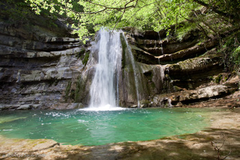
The first part of the stage is the very popular stroll leading to the Acquacheta.
Starting from the first sharp turn of the road to Marradi, one follows the easy path that goes up the valley of the Fosso dell’Acquacheta offering beautiful views of the stream.
After reaching the Molino dei Romiti one gets to the base of the Caduta, the most famous waterfall in the northern Apennines. Shortly afterwards, one crosses the Fosso del Lavane and then goes up to the gorgeous plateau of Romiti, inhabited by a monastic community in the Middle Ages.
Beyond the stream one continues until encountering a comfortable forest track that leads to the Crocione (976 m). Here one meets the road that climbs from the Eremo dei Toschi, visible in the lower left.
From this point, the hike continues along the semi-flat ridge until Muraglione Pass, an important road pass between Romagna and Mugello.
Going down on the Tuscan side, one almost immediately crosses the road to Tre Faggi Pass, then continues amid magnificent chestnut trees, coppice and old abandoned fields. Leaving the path that leads to San Godenzo the hike descends steeply to the bottom of the valley, skirting the stream for a while, before ascending near the restored village of Serignana.
After the cemetery of Castagno d’Andrea one arrives in a few minutes in the village, birthplace of the painter Andrea del Castagno and popular holiday resort at the foot of Mount Falterona.
Stage Locations and Services
Rifugio Punto Tappa GEA: Info
Bed & Breakfast Il Vado: Info
Bed & Breakfast Villa i Ciliegi: Info
Eremo dei Toschi o Eremo di Santa Maria: Info
Casa per Vacanze Borgo di Serignana: Info
Bivouac with tent: in some areas it is possible to spend the night in a tent, setting it up at sunset and dismantling it at dawn.
Interactive cartography
Visualize the route of this stage on the website "Rete escursionistica Emilia-Romagna"
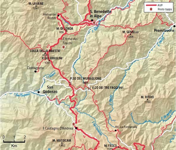
Map