The Alta Via dei Parchi
An hiking trail to walk through eight parks in Emilia-Romagna Region

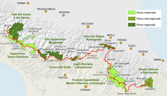
Alta Via dei Parchi is a trail to hike all along the Apennines between Emilia-Romagna, Tuscany and Marche Regions. It crosses several parks: two national, five regional and one interregional, and allows to discover the best that the Apennine mountains can offer.
The complete itinerary is about 500 kilometers long (> 30'000 m of elevation gain) and it is divided into 27 stages.
You can choose to hike this long trail by single stages or by undertaking longer trekkings of two or more days, thanks to the opportunity to reach most of the trail's access points by public transportation or private cabs.

Through the Alta Via dei Parchi and the Ciclovie dei Parchi, Emilia-Romagna Region promotes nature conservation and the valorization of the whole regional system of protected areas, also by development of sustainable tourism models.
In particular, the Region approved and funded the interventions proposed by the managing bodies of the Parks and coordinated the various actions of the project Alta Via dei Parchi:
- maintenance of the trail tracks;
- realization of a coordinated signage (coordinated image manual (PDF - 12,5 MB) - Alta Via dei Parchi – available only in Italian);
- production of disseminative and promotional material (brochures, guide, hiking maps, hiker notebook) and organization of dedicated events.
Protected Areas, Forestry and Mountains Development Department
Viale Aldo Moro 30, 40127 Bologna
+39 051 527 6080
segrprn@regione.emilia-romcertified e-mail: segrprn@postacert.regione.emilia-romagna.it
More info
- Trekking proposals
some 2-3-4-5-6-7 days trekking proposals - Camping opportunities along AVP
Publications
- The Leaflet
Downloadable version and the instruction on how to require the hard copy. - The Guide "Alta Via dei Parchi. Un lungo cammino nell’Appennino settentrionale"
Brief description of the guide, how and where to buy it. The Guide is in Italian. - The cartography
9 maps of the trails that cover the entire route and the territory of all the parks involved. The single maps and the box set, how and where to buy them. - The Hiker Notebook
what it is and what it includes, ow and where to buy it.
