
24. BADIA PRATAGLIA - LA VERNA
Badia Prataglia (Il Carbonile, 970 m)
La Verna (1128 m)
GRADIENT: +1280 m / -1120 m
HIKING TIME: 8,30 hours
Foreste Casentinesi, Monte Falterona and Campigna National Park
This is a long stage that leaves the ridge heading south in the direction of Mount Penna, clearly visible from the beginning of the hike. One can shorten the hike going directly to Mandrioli Pass and avoiding the detour to Frassineta, or by breaking it into two sections spending the night in Rambocchi (5 hours, +700 m/ -1120 m).
From the Carbonile, one follows the road towards Mandrioli Pass for a few hundred metres, then turns left towards Lupatti Pass; from there one reaches Mandrioli Pass by going along the ridge.
From the pass one goes on a rocky mule track that heads east, until skirting Mount Zuccherodante on the Tuscan side. Shortly thereafter, one meets the path that descends from Serra Pass, a mountain pass crossed by a mule track which for centuries was an important route between Romagna and Central Italy. In a landscape now more open, one follows the route of the ancient road towards Vallesanta, the valley of Corsalone stream dominated by the outline of Mount Penna.
Touching first the houses of Serra and then those of Corezzo, one descends to the valley floor of the Corsalone, then goes uphill on the opposite side of the valley to Frassineta, which is in a nice, panoramic location. Shortly afterwards one goes back down to the valley bottom at Rimbocchi, a place that may be reached directly from Serra, this way avoiding a great deal of difference in height.
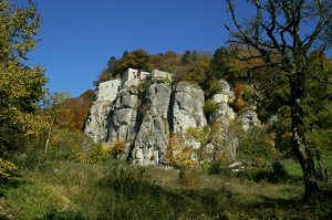
One follows the road to Chiusi for just a short distance, then crosses the stream and goes up to Casalino. Afterwards, a steep climb leads to the ridge above and then from there it passes the road that circumnavigates Mount Penna. One soon reacheshe foot of the cliffs, hiking through ancient landslides shrouded by forest, until arriving at the base of the cliff of Precipizio; the buildings of La Verna appear on its top.
Once through the gate, the hiker meets the old cobbled path that climbs from La Beccia, the main pedestrian access to the monastic citadel. Along this road St. Francis climbed the mountain for the first time nearly eight centuries ago, greeted by a flock of birds in celebration.
Stage Locations and Services
Posto tappa B&B Podere Casa Santicchio: Info
Canonica di Corezzo: Info
Foresteria e refettorio del Pellegrino – Santuario de La Verna: Info
Bivouac with tent: in some areas it is possible to spend the night in a tent, setting it up at sunset and dismantling it at dawn.
Interactive cartography
Visualize the route of this stage on the website "Rete escursionistica Emilia-Romagna"
Map
