Geological landscape of Emilia-Romagna
The “Emilia-Romagna Geological Landscape Map”, 1:250.000 scale. This map emphasizes the strong relationship between geology and landscape, showing how different rocks produce different features and different behaviour of the territory.
In addition to the census on geological heritage of Emilia-Romagna, and with a view to ultimately producing simplified geological maps for non-geologist users, the SGSS compiled The “Emilia-Romagna Geological Landscape Map”, 1:250.000 scale. This map emphasizes the strong relationship between geology and landscape, showing how different rocks produce different features and different behaviour of the territory.
The map shows the basic concepts of geoscience by looking closely at the landscape we see in front of us every day.From the coast to the Appenine watershed, the map identifies thirteen geological landscape units characterized by the presence of specific geological units and particular geomorphological characteristics.
1. Western peaks
Some sectors of the Apennine ridge which marks the boundary between Emilia-Romagna and Liguria and Tuscany to the west, are characterised by a landscape dominated by rocky reliefs, including M. Molinatico, M. Gottero and M. Lesima, with significant differences in elevation and “geometric”slopes entirely carpeted by forest. The stratification pattern is clearly visible in steep escarpments,being only slightly masked by the thick vegetation. Where the geological substrate is less cohesive and more clayey, the landscape is marked by saddles, and here we find the main mountain passes leading to Liguria (the Cisa, Cento Croci and Bocco passes).
The unit is formed by Cretaceous-Paleocene Flysch deposits consisting of alternating, highly cemented sandstones and thin beds of clay, regularly stratified and, in some areas, characterized by complex systems of folds, joints and faults. These rocks were deposited between 100 and 60 million years ago (between the Upper Cretaceous and Lower Paleocene). Peaks vary from 600 to 1720 metres above sea level and, due to this relatively modest altitude, even on the highest peaks it is rare to find morphologies shaped by glaciers during the last ice age.
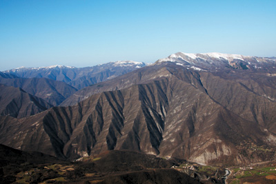
2. Mid-eastern peaks
The Apennine ridge between Parma and Bologna plus some sectors of the Piacenza and Romagna ridge are characterised by a landscape dominated by impressive mountains, with steep forest-covered slopes that include the region’s highest peaks: M. Cimone (2165 m), M. Cusna (2120 m) and Corno alle Scale (1945 m). In proximity to the principal ridges we can observe spectacular morphologies of glacial origin: numerous glacial cirques and, locally, roches moutonnée and striated rocks.Further down the valley, morainic deposits cover those areas reached by the glacial tongues.
The landscape unit comprises the Oligo-Miocene Macigno type sandstones. These consistof well stratified turbiditic sandstones (synonymous with Flysch), very well cemented with layers several metres thick intercalated with thin beds of clay . In some areas the stratification highlights the major anticlines, creating striking landscapes in which geology is very much to the fore. The Macigno type sandstones were deposited in a period between 28 and 20 million years ago (Upper Oligocene-Lower Miocene). Peaks vary from 800 to over 2000 metres a.s.l.
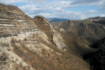
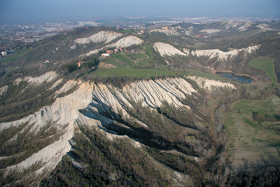
3. Mountains, Landslides and Badlands
This vast territory includes the majority of the medium altitude mountains and Emilian hills, as well as the Marecchia Valley in Romagna, with peaks varying from 150 to 800 metres a.s.l. The considerable geological and morphological complexity of this area gives rise to a composite landscape defined by striking contrasts. Gentle, often cultivated slopes alternate with badland erosions(calanchi), in some cases of quite remarkable size and depth, with conspicuous cliffs which are darker in colour and formed by ophiolites, and imposing rocky reliefs above covered with thick forest. This territory is distinguished by a particularly high density of landslides (the typical earth-flow type referred to as lame) both active and dormant,which cover one fifth of the territory making this the most landslide-vulnerable zone in Italy. On the slopes and valley floor, the rocky substrate is mostly formed by Argille Scagli ose or Scaly Clays: chaotic complexes in which the clay matrix incorporates various sizes of calcareous, arenaceous, marly and ophiolitic rocks. Inside them we find rocky complexes which, by virtue of their greater resistance to erosion, form the peaks. These are both vast portions of Cretaceous-Paleocene Flysch, formed by compact alternating argillaceous-arenaceous and/or marly-calcareous layers, and Epiligurian sandstones Oligo-Miocene).The rocks which makes up this complex landscape unit formed between 175 and 20 million years ago (Middle-Upper Jurassic – Lower Miocene). The majority of builtup areas located on clayey slopes, which are often farmed as meadowland, live with the day-to-day problems and hazards posed by the landslide-susceptible “Scaly Clays”. Dozens of clay quarries dot the landscape of the “ceramic industry district” in the provinces og Reggio Emilia and Modena.
4. Ophiolitic crags
The Ligurian-Emilian ridge and some sectors along the valleys of the rivers Taro, Ceno, Nure, Aveto and Trebbia are characterised by a wholly unique landscape, strongly shaped by the ophiolitic substrate. The highest peaks are M. Maggiorasca (1798 m) and M. Bue (1771 m): imposing mountains offset by smaller peaks further down valley. The landscape of the ophiolites is always very striking and prominent due to the extreme starkness of the sheer slopes, which are dominated by dark colours, with very sparse, sporadic ground cover. These are tremendously inhospitable environments, as we can deduce from the almost complete absence of agricultural activity and the very rare presence of dwellings.
The rocks which make up this unit are Ophiolites, a name which derives from the Greek words ophis (snake), and lithos (rock), in reference to their brilliant surface and colour, reminiscent of the skin of a snake. Ophiolites are a group of magmatic and metamorphic rocks (basalt, serpentinite, gabbro) forming the oceanic crust. Ophiolites outcropping in the Emilia-Romagna Apennines formed approximately 175 million years ago (Middle Jurassic) and thus testify to the presence of an ancient ocean which vanished long ago: the Ligurian-Piedmont Ocean. These large ophiolite rocks are almost always associated with
These large ophiolite rocks are almost always associated with rare, specialized flora which has adapted to very particular conditions like a scarce supply of water and, where present, a very thin layer of soil with high levels of heavy metals (nickel, chrome and zinc).
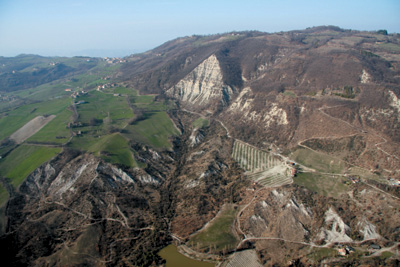
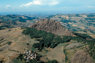
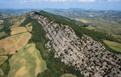
5. Sandstone spurs
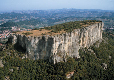
This unit extends over a vast section of the hill and mountain area of Emilia and upper Romagna,with elevations varying from 150 to 1000 metres a.s.l. It includes rocks of different ages which create a landscape defined by reliefs, often with tabular morphology or crags, bordered by sheer slopes androck faces (spurs). These landforms are a product of the low erodibility of the rocks which make up the unit. The rocks in question are stratified sandstones, with subordinated marls and conglomerates, separated through morphological steps by clayey slopes, which often present badland erosion, and by adjacent mountain sectors. Intermountain plains and small plateaus are to be found at the summit of isolated reliefs and between mountain groups. Some visually striking formations such as the Contrafforte pliocenic Pliocene Spur (Bolognese Apennines) and the Pietra di Bismantova or Bismantova Rock (in the province of Reggio Emilia) give rise to escarpments with sheer drops of over 100 m. The rocks from which these landscapes are shaped are both Pliocene sandstones and Epiligurian, i.e. Oligo-Miocene formations, prevalently arenaceous, belonging to Epiligurian Units (Ranzano, Pantano and Cigarello f.). These stratified rock masses vary in colour from grey to beige and yellow.
The rocks forming this unit were deposited between 33 and 2.5 million years ago (Oligocene- Pliocene). Slopes are wooded, while summit plateaus are home to urbanized areas surrounded by vast expanses of farmland. Many quarries dot the slopes of the Reggio Emilia and Modena hills, where the most clayey formations outcrop and locally, for instance in the Secchia valley, they have a major impacton the landscape. Landslides are a rare occurrence, but extremely hazardous given the precipitous slopes.
6. Window on the Deep Apennines
This unit includes the territory between Bobbio and Val d’Aveto (Piacenza province) as well as the Salsomaggiore area (Parma province). In this part of the Apennines, the landscape has been shaped by complex geological dynamics that have determined the exposure of rocks which, despite lying in the deepest parts of the Apenninic belt, are actually more recent than the overlying rocks. The term used to describe this geological phenomenon is tectonic window.
In terms of the landscape, tectonic windows appear as mountain and hill sectors which seem virtually unrelated to the surrounding environment, due to the different nature of the outcropping rocks and the intensity of erosive processes involved. A prime example is the meanders of the river Trebbia south of Bobbio, unique landscape features in this region. The rocks that make up this unit are turbiditic sandstones: those at Salsomaggiore belong to the Marnoso-Arenacea Formation (see LAYER UPON LAYER), while at Bobbio we find outcrops of Oligo-Miocene turbidites (see MID-EASTERN PEAKS). These rocks originated between 33 and 11 million years ago (Oligocene – Middle Miocene). Slopes in the “Bobbio window” are either thickly wooded or rocky. Thanks to a gentler morphology and close proximity to the plain, in the area of Salsomaggiore woodland, built-up areas and farmland alternate.
7. Triassic gypsum
In a circumscribed area of the mid and upper Secchia valley (Reggio Emilia province) we can observe an extraordinary Triassic gypsum outcrop carved out by the course of the River Secchia. The broad bed of the Secchia (as wide as 500 metres in places) flows in a straight course for 6 kilometres between towering rock-faces of white, pink and light grey gypsum, rising up 200 metres in some points. The numerous morphological “anomalies”make this landscape unique within the Apennines. It is shaped by a number of karstic phenomena: there are many swallow holes, spectacular karst springs and quite unique caves. The continuity of the gypsum is interrupted by lateral valleys with large clay flows which originally broke off from the distant slopes of the rock of Bismantova and from M. Ventasso. Moving towards the Cerreto pass, a distinguishing feature of the landscape is the wide front of the “Rivarossa Quarry” with its extraordinary outcrops of the pinkish-white quartzite typical of this rock complex. Triassic gypsum contains a number of different lithologies: gypsum, anhydrites, dolomite and quartzite, which form a distorted rock structure with fragments of layers that present rupture and folding, where all original stratification has been erased by powerful tectonic forces. The rocks which make up the unit were deposited during the Middle-Upper Triassic (245-200 million years ago) and are, therefore, the oldest rock outcrops in the Emilia-Romagna Apennines. The steep gradients, coupled with instability brought about by karstic phenomena, make this a highly inhospitable area, with thickly wooded or rocky slopes.
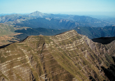
8. Layer upon layer
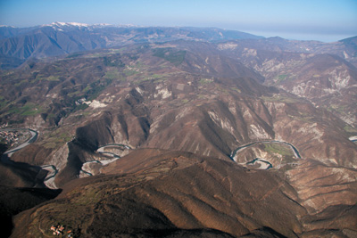
The unit comprises much of the hill and mountain territory of Romagna, with peaks varying from 50 to 1650 metres a.s.l. Lithological homogeneity results in a relatively uniform landscape. The rocky substrate belongs almost exclusively to one formation, the Marnoso-arenacea formation, whose italian name indicates the two principal lithological components which are sandstones and marls. This is a sizeable and impressive turbiditic formation, composed of a rhythmic, repetitive sequence of yellowish-beige layers of sandstone and grey coloured marly layers; based on the predominance of one lithological type as opposed to the other, we can divide the formation into inner Marnoso-Arenacea and outer Marnoso-Arenacea. In the upper Apennines, the landscape is defined by the tenacious nature of the inner Marnoso-Arenacea , organized in thick sandstone layers which predominate over the marly portions, resulting in steep, wooded slopes, scored by straight furrows with sunken meanders, bends, waterfalls and, locally, potholes. In the central and lower Apennines the landscape is somewhat gentler thanks to the lithological nature of the outer Marnoso-Arenacea where there is a decrease in the sandstone percentage, in terms of both the thickness of layers and the ratio of sandstone to marl.
The pattern of stratification shapes the landscape, its position determining the ridge profiles. Long, gently pitched slopes form where the layers lie parallel to the slope, while, beyond the ridge, strata dippinginto the slope result in steep escarpments. This asymmetry, which is to be found above all in the secondary ridges, has a significant correspondence also in the physical aspect of the landscape in terms of flora, with gentler slopes covered with woodland, meadowland and farmland, while steeper gradients are often stripped of vegetation, sparsely wooded or reforested. The easternmost peaks are home to the region’s only millenary forest, located in the Sasso Fratino nature reserve, within the Foreste Casentinesi.The rocks that make up this unit were deposited during the Lower-Middle Miocene (23-13 million years ago).
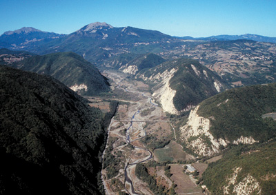
9. Foothills
This landscape unit extends along the entire pede-Apenninic margin, from the area of Piacenza to Rimini, with gentle hills very gradually rolling down to meet the plain. The landscape is characterised by a gentle morphology expressed in long terraces sloping down towards the valley, where we also find ancient paleosoils. Local erosion of the secondary hydrographic network has resulted in quite shallow valleys, separate from ridges with large summits where the “yellow sands” that compose the rocky substrate outcrop.
Uphill, this landscape finishes where it meets extensive badland basins, where grey-blue Pliocene clays outcrop. In some cases the badlands cover a vast area, as in the valleys of Romagna, Modena, Reggio Emilia and Piacenza. The rocks that compose this unit belong to the Argille Azzurre (Blue Clays) and sabbie gialle (yellow sands) or Imola Sands Formations which were deposited between 5.3 and 0.01 million years ago (Pliocene - Pleistocene). Among the Pliocene clay found in the Romagna hills, we also find a very distinctive rock, an organogenic limestone referred to as Spungone, which is responsible for a landscape of cliffs and high hills which develop along a continuous narrow strip straddling the valleys. This area, with its very gentle landscape, has always attracted man and today it is heavily farmed, with fruit orchards and vineyards the preferred cultivations.
10. Vena del gesso
The unit extends along a narrow strip of territory which runs parallel to the Apenninic margin through the territories of Reggio Emilia, Bologna, Imola-Faenza and the hill area of Cesena. The most visible expression of this unit in terms of the landscape occurs in Romagna, where it culminates in a long and very impressive ridge, silver grey in colour, which interrupts the gently rolling hills. The ridge, which can be seen from a great distance despite the fact that it measures just 1500 metres at its broadest point, is the longest and most imposing gypsum ridge in Italy, stretching for 25 kilometres. To the south, the del Vena del Gesso (Gypsum Vein) rises up over 100 metres above the surrounding clayey slopes and is divided into strata, often up to 30 metres thick, separated towards the top by clay beds which support the vegetation. To the north, the ridge rises up with a steep yet more gradual flank, dotted with dolines and swallow holes, the majority of which are covered by woodlands. There are numerous karst landforms and caves where speleological exploration is the only way to admire the geological environment.
The gypsum outcrops to the west (Bologna and Reggio Emilia hills) are less striking in terms of morphology, but still form unique, remarkable environments. The gypsum forming this unit, known as the last age of the Upper Miocene. These environments are home to rare species of flora and fauna, and man’s presence here can be traced back to ancient times. There are a number of very grand caves, with tunnels and white stepped escarpments, in the gypsum rock between Emilia (Vezzano sul Crostolo) and Romagna (Val Senio).
11. Alluvial plain of the Apennines rivers
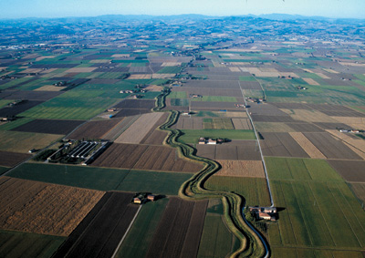
This includes the inter-valley sectors of the Apennines, valley mouths along the Apennine margin and the large plain stretching all the way to the river Po and the coast. Elevations are generally between 100 meter a.s.l. (in the upper plain area, with the exception of inter-valley sections) and sea level in coastal areas. The landscape owes its primary characteristics to the dynamics of the Apennine rivers which, after an inter-valley course during which they form small ribbon-like deposits, they flow into the plain (upper plain), depositing their coarse load of gravel and sand and forming sedimentary bodies: the alluvial fans, characterised by a system of fluvial channels. The middle and lower plain is associated with decreasing slope gradients (around 0.1-0.2 %) and smaller sediment grain size. In this sector, river dynamics are characterised by repeated deviation of the rivers, the traces of which are preserved in levees: elongated depositional reliefs which are several metres high and elevated above the surrounding land, formed by the current-day and ancient courses of rivers following repeated overflowing ( channel-levee and overbank deposits ). In those areas farthest from the fluvial systems we find marshlands, the majority having been reclaimed during the last century, where overflowing rivers deposited clay and silt by a process of decantation. Regular water discharge is currently guaranteed by land reclamation works. The plain is a fully anthropized territory where, for over 3000 years, man has shaped the landscape through a combination of artificial embanking and rectification of rivers, reclamation of valleys and intensive urbanization; these actions have blocked the natural evolutional dynamics of the floodplain. Today the plain is fully farmed and presents a level of industrialization which, along the via Emilia, is one of the highest anywhere in the world.
12. Po plain
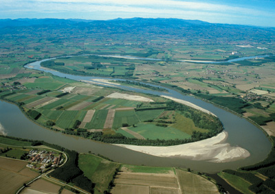
This area includes the land occupied by the corridor of the great river, by the mouths of its various branches and ancient deposits, namely the ancient deltaic system which today covers an area of over 2000 km2 in the province of Ferrara. Elevations reach 70 m with frequent values in excess of 100 m in the west, dropping to below sea level in the lowest-lying areas of the delta coastal plain. Due to the very slight gradient, the river corridor, which marks the northern boundary of Emilia-Romagna, has a sinuous, twisting trend which defines the typical fluvial meanders of the Po. Just before it flows into the sea, the gradient and velocity of the river become so low that the main river channel tends to split into divergent branches (distributary channels): from here on, the river leaves the alluvial plain and constructs the delta coastal plain. The main morphological elements of the delta coastal plain are: the delta channels and levees, corresponding to the distrubutary channels of the Po river (the ancient branches of the Po di Primaro, Po di Volano and other minor branches), and the delta valleys, depressions which were in the past marshland or lagoons (inter-distributary areas). In the delta channels, fresh water from
the river mixes with salt water carried up the river during high tide. Originally, in those areas of the delta farthest inland, lakes of no more than a few metres in depth, or marshland, stood where now there are valleys. Towards the sea, meanwhile, there were lagoons and bays of shallow water. Today, on the other hand, the area has been almost completely drained as a result of monumental land reclamation projects undertaken in the past two hundred years; many parts of the territory lie several metres below sea level, with barely perceptible landforms providing clues to the past.
13. Coastal plain
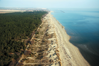
This strip of land lies parallel to the coast, running alongside the sea for approximately 130 km from the Po di Goro mouth to the Gabicce headland. Low-lying, with elevations generally between -2 and 1 metre a.s.l. the plain is characterized by an ancient system of north-south facing elongated dunes, clear evidence of ancient shorelines, interrupted here and there by bodies of palustrine water and by river levees. Along the stretches of coastline which still retain some natural aspects, the beaches widen out back to the coastal dunes, formed by the onshore wind sweeping the grains of sand. Inland, traces of fossil dunes have been found; once common, these have virtually disappeared nowadays as a consequence of anthropic activity. Among those which can still be admired today are the dunes of Massenzatica, in the protected area of a regional nature reserve, which stand over 8 m above the surrounding plain, marking the Copper Age shoreline. The large wetlands near the coast provide important geo-morphological clues to the past: they may be part of ancient delta lagoons and marshes, like the Comacchio Valleys and the Bertuzzi Valley, or landforms which indicate moments of rapid accretion of the shoreline towards the sea, as with the fascinating Piallasse Ravennati and the Vene di Bellocchi o. Over the last fifty years the area has been highly urbanized,beachfront bathing establishments, ports, wharfs and coastal defence works (breakwaters, piers) have been built, altering the natural morphodynamic characteristics of the beach. There are increasingly fewer areas today where we can still observe typical beach morphology, with sandy dunes behind the beach, or a river outlet unconfined by man-made banks.