The Pedogeochemical Map of the Emilia-Romagna plain
The Pedogeochemical Map of Co, Cr, Cu, Pb, Ni, V, Zn of the Emilia-Romagna plain at 1:250,000 scale. Third edition (2024)
According to the Thematic Strategy for Soil Protection (COM 2006/0231), soil is regarded as non-renewable resource. In an environmental perspective, the Italian Law for Enviroment (D.lgs 152/06) considers soils as environmental matrix, like air and water. Soil also has several different functions and represents an essential support to human activities and to ecosystem survival.
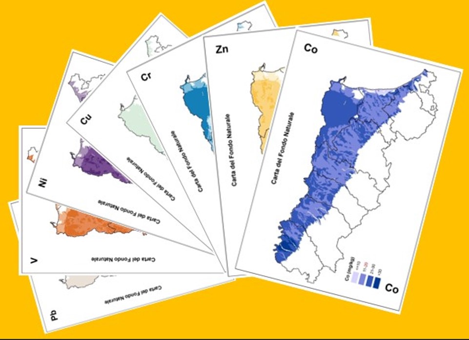
The Pedogeochemical Map of the Emilia-Romagna plain at 1:250,000 scale represents the areal distribution of the pedo-geochemical content (according to ISO 19258,2005 definition) of seven potentially toxic metals in agricultural soils: Cobalt (Co), Chromium [Cr], Nickel [Ni], Zinc [Zn], Copper [Cu], Lead [Pb] and Vanadium [V].
The third edition of the Pedogeochemical Map is the result both of surveys carried out between 2002 and 2015 than a detailed analysis of the ophiolitic rocks content in the Apennines catchments. The Pedogeochemical Map of Cobalt is in its first edition.
The knowledge of the natural background (or pedo-geochemical content) of heavy metals in soil is provided for by law. This is the basis for a correct evaluation of diffuse contamination and lays the foundations for proper land management choices.
Available maps
-
-
-
-
-
-
Papers
- Fingerprinting sedimentary and soil units by their natural metal contents: A new approch to assess metal contamination (PDF - 3,1 MB) (PDF - 3,1 MB), journal "Science of the Total Environment", 2014
- Contribution of soil studies to geochemical mapping:the example of Emilia-Romagna alluvial plain (PDF - 14,3 KB) (PDF - 14,3 KB), Geoitalia, vol.3, 2009, p.110.
- The pedogeochemical map of Emilia alluvial plain (1:250.000 scale) (PDF - 12,0 KB) (PDF - 12,0 KB), Geoitalia, vol.3, 2009, p.113.
- The pedogeochemical map as a support for environment planning strategies in Emilia-Romagna (PDF - 697,3 KB) (PDF - 697,3 KB), RemTech, Poster Ref no 105, 2009.
- The pedogeochemical Map of Parma alluvial plain: contribution of soil studies to geochemical mapping (PDF - 1,4 MB) (PDF - 1,4 MB), GeoActa, vol.6, 2007, pp.11-13.
Links
- BGR- Background values for trace elements in German soils
- Geochemical Atlas of Europe
- European Commission- Joint Research Centre. Heavy metals in topsoils
- Contamination en élements traces métalliques (ETM)
- GEMAS – Chemistry of Europe’s Agricultural soils
Web mapping
- Soil maps of Emilia-Romagna
- Soils of Emilia-Romagna
- Minerva Portal
It's possible to query and download metadata and data in open data format (shapefiles, WMS, CSV and TXT tables).
It is a webgis site that contains all published maps (soils maps and derived maps), as well as some point layers (Extension Service soil analyses, heavy metal analyses, shallow groundwater network stations). It allows simultaneous consultation of multiple layers. Many aerial flight/satellite images from 1944 to 2023 are available. It is especially aimed at users in the environmental and educational sectors.
It is an easy-to-use site that describes the main features of the region's soils and landscapes. Through Google Earth, it makes available the cartography of Emilia-Romagna soils at different scales (from scale 1:1,000,000 up to maps of farm soils). In the "Thematic Maps" section, it is also possible to consult application maps (e.g., use capacity, natural anthropic background of heavy metals) and maps of the chemical-physical properties of soils (e.g., organic C content, natural background of heavy metals, texture, pH, salinity).
Contact us
Geological, Soil and Seismic Area