Salinity, calcium carbonate and pH
Soil Salinity and pH maps of the Emilia-Romagna region
Soil salinity
Soil salinity is the soluble salt content in the soil, mainly chlorides (Cl-), sulphates (SO42-),bicarbonates (HCO3-) and different types of carbonates (CO32-): calcium (Ca2+), magnesium (Mg2+), sodium (Na+) and potassium (K+). The problem of soil salinisation (the process of increasing the salt content) is considered a threat and a soil degradation element in the Communication from the European Commission "Thematic Strategy for Soil Protection” (COM/2006/0231). In this document soil salinisation has been proposed as a research field: “Further research is necessary to close the gaps in knowledge about soil and strengthen the foundation for policies”.
Following these indications and in accordance with the Regional Agricultural Extension Service salinity maps of the soils of Emilia-Romagna plain at 1:250,000 scale (first/second edition) have been prepared.
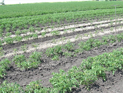
Salt efflorescence affecting tomato plant growth in Mezzano valley (photo by Raimondi)
Soil salinity maps describe the status of salinity in topsoil (layer 0-50 cm) and subsoil (layer 50-100 cm), using the electrical conductivity of saturated paste extract at 25°C (dS/m). ECe values are classified according to Soil Survey Manual (1993).
These maps are a first regional-scale spatial representation derived by geo-statistical analysis on point data collected in different soil surveys.
Total calcium carbonate
Total calcium carbonate is the mineral component of soil consisting mainly of calcium, magnesium, and sodium carbonates and is expressed as calcium carbonate (CaCO3), as this is the predominant element. The total calcium carbonate map, drawn up in collaboration with CNR-IBE, shows how soils are distributed across the region based on their total calcium carbonate content in the 0-30 cm layer. This map is a raster layer, with 100mx100m pixels.
Active calcium carbonate
Active calcium carbonate is the finest fraction of total calcium carbonate and is easily soluble in the circulating solution. It therefore interacts most with the physiology of the root system and the absorption of various elements. In particular, it influences the availability of phosphorus and iron, forming highly insoluble compounds with them that cannot be assimilated by the plants. The presence or absence of active calcium carbonate can be limiting for some crops; in particular, many tree crops are sensitive to active calcium carbonate contents > 8-10%. The active calcium carbonate map, drawn up in collaboration with CNR-IBE, illustrates how soils are distributed across the region based on the active calcium carbonate content in the 0-30 cm layer. This map is a raster layer, with 100mx100m pixels.
Soil reaction (pH)
The term pH or reaction refers to a numerical index related to acidity, that is the concentration of hydrogen ions in the soil solution. This parameter exerts a strong influence on the chemical, physical and biological characteristics of the soil.
Also in collaboration with CRN-IBE of Florence, the "Map of pH in the soils of the Emilia-Romagna region" was prepared, with reference to the first 30 cm of soil, which provides an estimate of the pH value in a given territorial area because of the different types of soil present in it. This map is a raster layer, with 100mx100m pixels.
Available maps
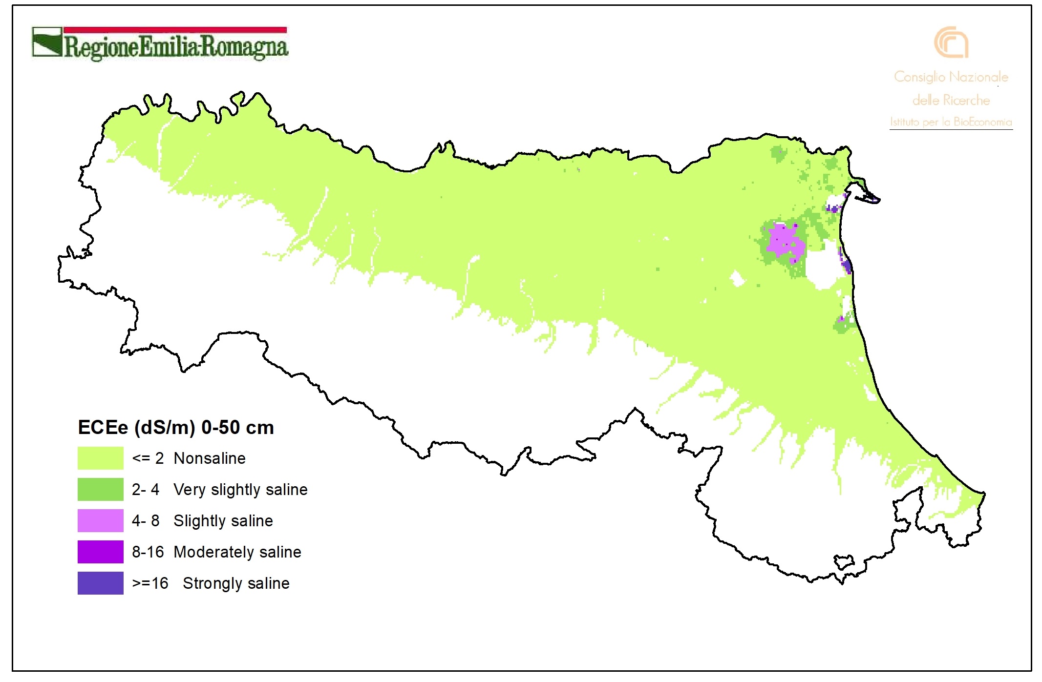
Electrical conductivity ECe(dS/m), layer 0-50 cm (2015). Vector layer (tile 500mx500m). DOWNLOAD
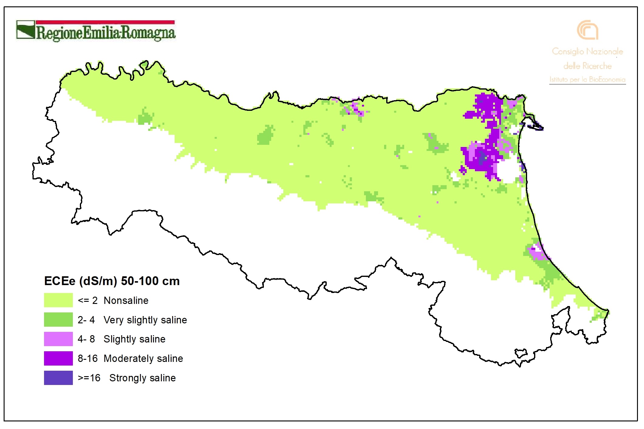
Electrical conductivity ECe(dS/m), layer 50-100 cm (2011). Vector layer (tile 1kmx1km). DOWNLOAD
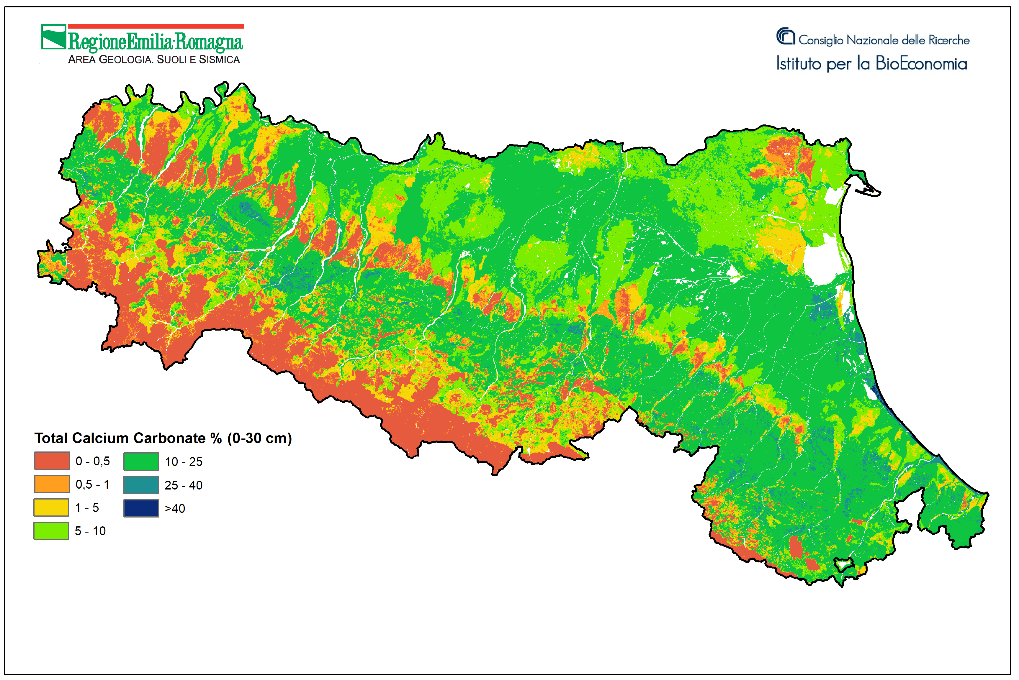
Soil Total Calcium Carbonate 0-30 cm layer (2025). Raster layer (pixel 100mx100m). DOWNLOAD
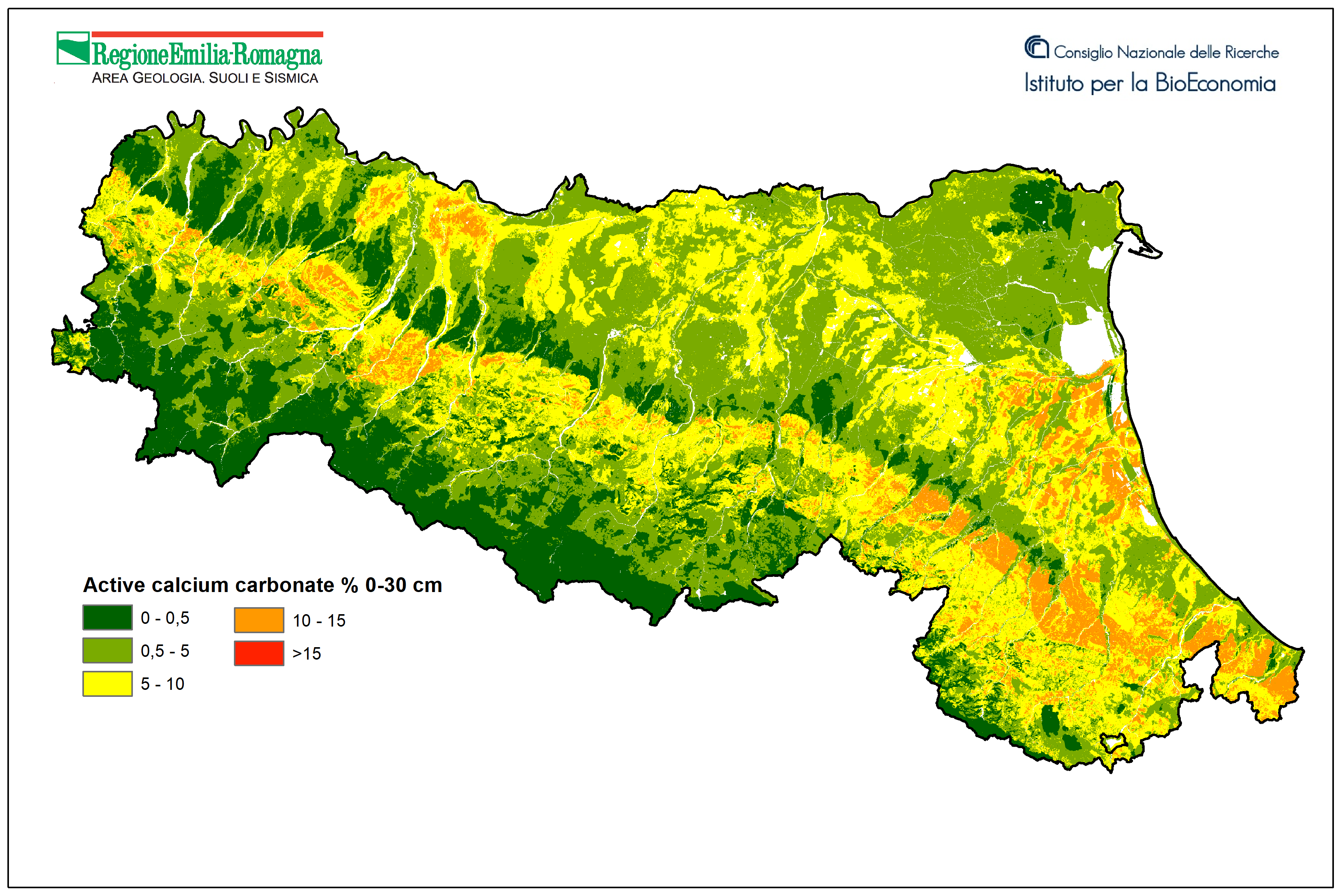
Soil Active Calcium Carbonate 0-30 cm layer (2025). Raster layer (pixel 100mx100m). DOWNLOAD
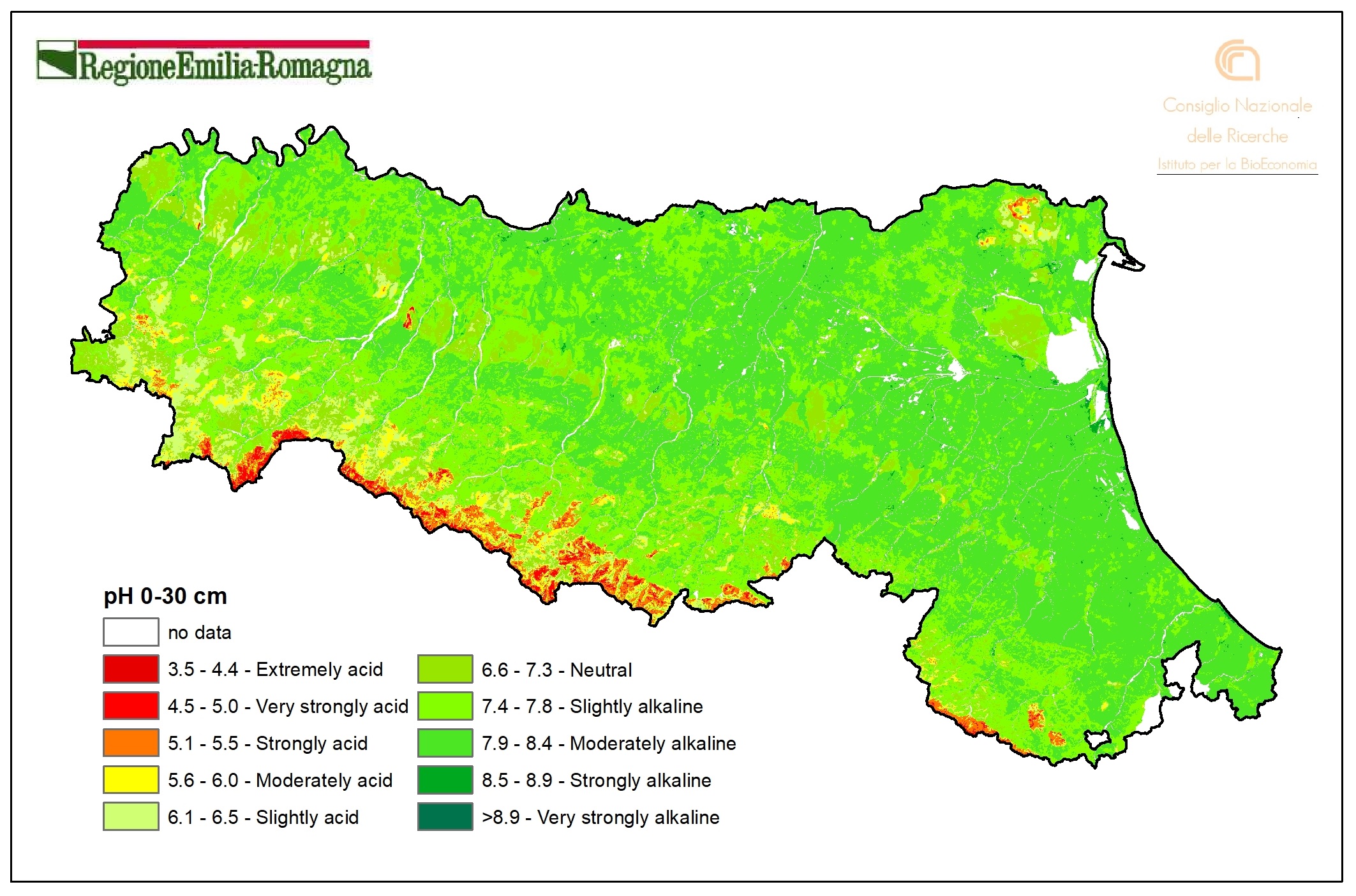
Soil pH 0-30 cm layer (2023). Raster layer (pixel 100mx100m). DOWNLOAD
Web mapping
- Soil Catalog of Emilia-Romagna
The website provides access to 1:50k soil map and point data (extension service soil analyses and shallow water table measurement sites). A selection of derived thematic maps is available as well. It’s possible to draw plots, to identify a soil type using a tool and to calculate the fertilisation plans. It is especially aimed at users in the agricoltural sector. - Soil maps of Emilia-Romagna
- Soils of Emilia-Romagna
- Minerva Portal
It's possible to query and download metadata and data in open data format (shapefiles, TIFF, WMS, CSV and TXT tables).
It is a webgis site that contains all published maps (soils maps and derived maps), as well as some point layers (Extension Service soil analyses, heavy metal analyses, shallow groundwater network stations). It allows simultaneous consultation of multiple layers. Many aerial/satellite images from 1954 to 2023 are available. It is especially aimed at users in the environmental and educational sectors.
It is an easy-to-use site that describes the main features of the region's soils and landscapes. Through Google Earth, it makes available the cartography of Emilia-Romagna soils at different scales (from scale 1:1,000,000 up to maps of farm soils). In the "Thematic Maps" section, it is also possible to consult application maps (e.g., use capacity, natural anthropic background of heavy metals) and maps of the chemical-physical properties of soils (e.g., organic C content, natural background of heavy metals, texture, pH, salinity).
