Local benchmark sites of Emilia-Romagna soils
Local benchmark sites representative of soils described in the 1:50k soil map with chemical-physical analyses
The 1:50,000 Soil Map of the Emilia-Romagna Region covers the whole plain, most of the hills and a small part of the mountains. Soil information is disseminated not through Soil Map Units (aggregation of similar polygons), as is normally the case for soil maps, but by single polygon (defined as delineation).
Each individual polygon is uniquely identified: in the 2021 edition 13,353 soil polygons were delineated, of which 2,230 in the plain, 5,188 in the hills and 5,935 in the mountains, and described for the soils that make it up, both in terms of percentage spread and location. The description by single polygon therefore also allows information to be given on local particularities that would be lost in the description by map units. The description of each polygon allows to provide specific information on local soils. This is not possible using a Mapping Unit description. Within a soil polygon the number of soil types (Soil Typological Units) ranges from one to twelve (on average 3-4).
At a scale of 1:50,000, which is defined as semi-detail, it is almost never possible to delineate 'pure' polygons, i.e. composed of a single soil type.
At present, 466 soil types have been described for this scale (210 in the plain, 162 in the hills, 94 in the mountains). Some of these are widespread and occupy thousands of hectares throughout the region, others are very uncommon and are only found in particular locations.
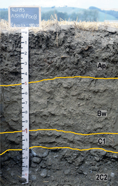
Each soil type is described by a representative profile, which provides a concise idea of soil characteristics.
To facilitate the use of the 50k soil map, each soil in each polygon is linked to an analysed site that was surveyed and sampled in the same or adjacent polygons. The choice of these sites (representative sites or benchmark sites) takes into account the local variability.
For this purpose have been selected from the Soil Information System 3,265 observation sites (profiles and auger holes) that have, at least up to a depth of 100 cm, these analytical data:
- sand, silt and clay (%);
- pH
- organic carbon (%)
- total calcium carbonate (%)
Active calcium carbonate (%) and CEC (Meq/100g) are available sometime, whereas bulk density and Ksat (cm/h) values, derived mostly by pedotransfer functions, are always present.
The 3,265 sites correspond to 11,902 samples, with an average of 4 samples per site (minimum 1, maximum 14) up to an average depth of 100 cm: a minimum of 30 cm for skeletal soils or soils with lithic or paralithic contact up to a maximum of 500 cm for highly developed soils.
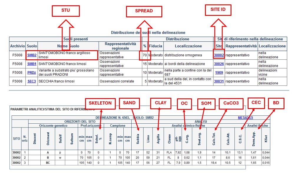
Example of description of a soil delineation and a local benchmark site
In the 2021 edition, given the chronic lack of local sites in hilly and mountainous areas, it was decided to supplement the local sites with regional reference sites. However, an attempt was made to choose, as far as possible, the regional site best suited to the local situation.
As a result, 91% of the delineations have representative sites for each of their component soils and only 9% have representative sites for only some of the soils present. The 70 polygons consisting of 100% rocky outcrops (abbreviation ZR) were considered complete. On 9% of the incomplete delineations, the attribution to the regional site was made only considering the soil type and not any local variations. In these cases the item 'representativeness of the reference site in the delineation' is not filled in and in the field 'location' the word 'regional' is entered. Thus, only 7% of the polygons present the benchmark site for only some of the soils present.
Benchmark sites can be used for many applications, such as:
- Soil Type Identification;
- Input data for irrigation projects;
- Input data for Water Balance Models (e.g. MACRO, PELMO);
- Input data for fertilization models;
- Input data for Risk Assessment Models for contaminated sites (e.g. ASTM E2081).
- Construction of thematic maps (e.g. Ksat, soil ecosystem services, land suitability, land capability maps)
Web mapping
- Soil Catalog of Emilia-Romagna
The website provides access to 1:50k soil map and point data (extension service soil analyses and shallow water table measurement sites). A selection of derived thematic maps is available as well. It’s possible to draw plots, to identify a soil type using a tool and to calculate the fertilisation plans. It is especially aimed at users in the agricoltural sector. - Soil maps of Emilia-Romagna
- Soils of Emilia-Romagna
- Minerva Portal
It's possible to query and download metadata and data in open data format (shapefiles, raster, CSV and TXT tables).
It is a webgis site that contains all published maps since 2010 (soils maps and derived maps), as well as some point layers (Extension Service soil analyses, heavy metal analyses, shallow groundwater network stations). It allows simultaneous consultation of multiple layers. Many aerial/satellite images from 1954 to 2023 are available as background. It is especially aimed at users in the environmental and educational sectors.
It is an easy-to-use site that describes the main features of the region's soils and landscapes. Through Google Earth, it makes available the cartography of Emilia-Romagna soils at different scales (from scale 1:1,000,000 up to maps of farm soils). In the "Thematic Maps" section, it is also possible to consult application maps (e.g., use capacity, natural anthropic background of heavy metals) and maps of the chemical-physical properties of soils (e.g., organic C content, natural background of heavy metals, texture, pH, salinity).