Fieltrip to the Secchia valley (Reggio Emilia)
The Secchia Valley: Introduction
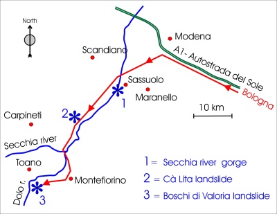 Fig.1 Itinerary and stops
Targets of the fieldtrip are three examples of hydrogeological instability that took place in the Secchia valley during the last decades and that are still in process. These instabilities represent the typical degradation quite diffused in the Apennines.
The bus will depart from Bologna and after 55 minutes (70 kms) the A1 motorway “Autostrada del Sole” will led us inside the Secchia valley, near Modena, Sassuolo, Maranello, where three visit sites are located.
Field trip has been organized by the Emilia-Romagna regional surveys (Tecnico di Bacino degli Affluenti del Po and Geologico Sismico e dei Suoli) in collaboration with the University of Modena and Reggio Emilia.
The Secchia river gorge
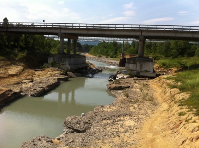 Fig.2 The Secchia river gorge
During the last 20 years, the pede-apenninc section of the Secchia river dug its thalweg firstly inside the thick alluvial mattress, that was completely eroded, and then in the rocky substratum, thus forming a geological outcrop 11 kms long. In the bottom of this small “canyon” (up to 20 meter deep) several formations, from Cretaceous to Holocene in age, now appear.
The causing factors that led the erosion taking place are various, from climatic to anthropogenic.
Secchia valley:The monitoring system of the Boschi di Valoria landslide
The main certainly was the wild mining overexploitation of the ancient alluvial mattress, made by gravel and sands. Dams and similar engineering structures against riverbank erosion were recently undermined and destroyed by the uncontrolled stream.
The field discussions will be led by experts of regional authority.
The first movements of the “Boschi di Valoria” landslide (13 x 106 m3 in volume) began five months before the complete reactivation that occurred in April 2001, when the landslide accelerated due to the melting of the snow cover, thus involving the basal fan that slid about 10 m.
The main superficial earth flow overtook the landslide foot and reached the Dolo River, but the landslide material did not form a dam because of its fluid state.
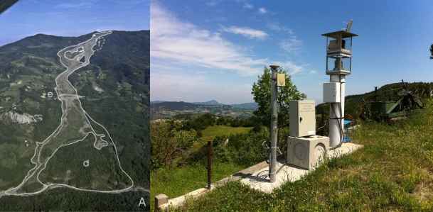
The main feature of this landslide is the 1.8 km long “channel”, 200 m wide, where the clayey material flows in an impressive way, sometimes reaching a thickness of about 20 m. (Figure 3)
The high movement rate (10 m/h) is also due to the unusual slope angle (13°) that is 2-3 ° superior to the mean. In the last three years, the source area has extended several more tens of metres in all directions. The main scarp has migrated for about 210 m uphill - through rotational/translational sliding - accumulating a large amount of new unstable clayey material in that area.
Nowadays, after nine years, several portions of the landslide are still moving. In order to restore the interrupted road, the provincial administration has built a 160 m long bridge that will overtake the landslide "channel".
In order to face front to the dangerousness of the landslide an early-warning monitoring system has been implemented by regional services (Figure 3).
This will be the main object of interest of the field trip, thanks to Professor Alessandro Corsini (University of Modena and Reggio Emilia) that will led the discussions in the field.
Secchia valley:The consolidation works of the Cà Lita landslide
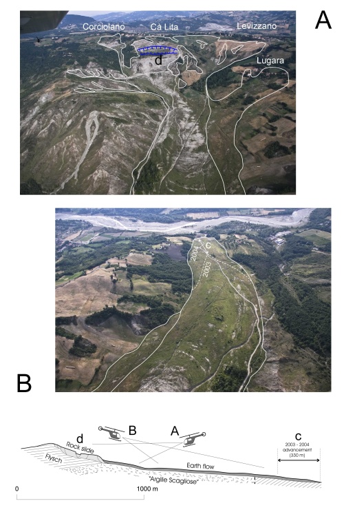 Fig.4 Cà Lita landslide
An earthflow formed in the source area of Cà Lita landslide in 2002 and moved downward, thus triggering the main landslide body (42 x 106 m3 in volume).
The foot, up to 30 metres thick, advanced 330 metres, mostly during the winter 2003-2004, burying the abandoned valley bottom (Figure 4).
The increase of the foot volume amounts to half a million cubic meters, corresponding to 0.01 % of the entire landslide. In the meantime, a 43 m deep rock slide was triggered in the Cà Lita source area.
The precipitations that led the Cà Lita landslide to reactivate were certainly not exceptional (only 120 mm in 30 days, 11 % of average annual precipitation).
The 2002 reactivation was anticipated, during the previous decade, by separated movements in the several branches that form the complex source area.
This “minor” activity certainly represents the main preparatory factor causing the progressive instability and, in the end, the collapse of the slope.
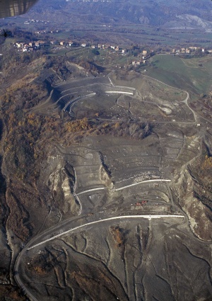 Fig.5
Fig.5
The intensity of deformation of the landslide body was so much great as a result of the very heavy snowfall of the winter 2003-2004 amounting to a cumulated value of about 1.90 metres in the Febbio gauge. Expensive but cost-effective stabilisation works have been implemented in the source area by regional services: structural walls sustained by piles and anchors were coupled with a long net of drainage wells (Figure 5).
The effectiveness of this kind of works will be the main target of the field discussions, led by experts of Emilia-Romagna region Autority.
-
Go to the Secchia Valley registration form
