Catalogue of soil maps and derived thematic maps
List of published maps on soil (watch, read, download online).
Web Map Service
Many maps are available in WMS format at the URL https://servizigis.regione.emilia-romagna.it/wms/suoli.
Soil maps
MAP | WEBGIS | DESCRIPTION |
|---|---|---|
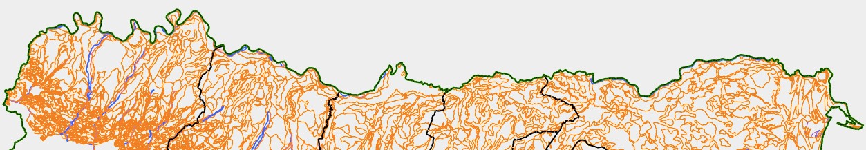
Soil Map at 1:250,000 scale1994 | WMS | This map describes the soils and their geographical distribution in the Emilia-Romagna region at 1:250k scale |
Soil map at 1:50,000 scale2021 | WMS
| This map describes soils and their geographical distribution in the alluvial plain and in some parts of the Appennines at 1:50k scale. The map covers 78% of the regional territory: the whole plain, 93% of the hills and 23% of the mountains. |
Local benchmark sites of the soils2021 | WMS | A local benchmark site is linked to every soil type in every polygon of the 1:50k soil map: users can view and download chemical and physical analyses (sand, silt, clay, pH, organic carbon, total carbonate, bulk density and Ksat). |
Experimental farm soil map at 1:10.000 scale 2005 | This layer contains 1:10k soil maps of some experimental public farms in the Emilia-Romagna region. |
Maps of chemical and physical properties of soils
MAP | WEBGIS | DESCRIPTION |
|---|---|---|
Extension Service soil analyses 2023 | WMS | These data are about 43,500 routine chemical-physical analyses (sand, silt, clay, pH, total carbonate, active carbonate, organic matter, exchangeable K, available P, total N) of soil samples (mostly on superficial horizons). Their use is for extension service in Agriculture and to improve the description of the soil polygons. |
Heavy metal data inventory 2018 | This map is a point layer and it groups 1,906 analyzed soil samples (heavy metals content with aqua regia method) at a depth of 20-30 cm. This data were used with a geo-statistical approach to produce background maps of 9 heavy metals. | |
Shallow Water Table Measurement Sites 2024 | WMS | This map is a point layer and contains 179 measurement sites of the shallow water table (0-3 m) in the alluvial plain of the Emilia-Romagna region. Water depth data are collected approximately every 10 days. |
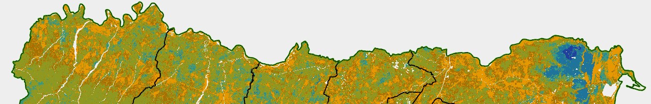
percentage content in the 0-30 cm layer 3nd edition - 2023 | WMS | This map provides the estimated average percentage content of Organic Carbon at the depth of 0-30 cm in the soils of the Emilia-Romagna region. It's a raster layer, with pixels 100 m x 100 m wide. Each pixel contains a classified value and a medium content (weight %) of Organic Carbon at the depth 0-30 cm. These values derive from geo-statistical analysis and digital soil mapping on point data, based on the 1:50.000 Emilia- Romagna Soil Map and other covariates. |
percentage content in the 0-100 cm layer 1st edition - 2016 | WMS | This map provides an assessment of the average percentage content of Organic Carbon at the depth 0-100 cm in the alluvial plain of Emilia-Romagna region. It is a vector tiles layer, with cells 500m x 500m wide. Each cell contains a classified value and a extimated content (weight %) of Organic Carbon at the depth 0-100 cm. This value derives from geo-statistical analysis on point data, on the base of 1:50,000 Emilia- Romagna plain Soil Map. |
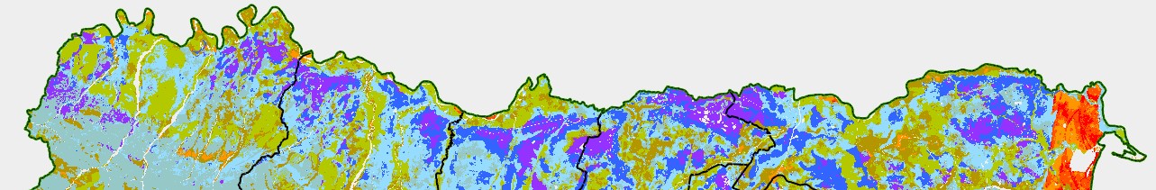
Soil texture in the 0-30 cm layer 2nd edition - 2023 | WMS | This map provides an assessment of the average percentage content of sand, silt and clay at a depth of 0-30 cm in the soils of the Emilia-Romagna region. It's a raster layer, with pixels 100m x 100m wide. Each pixel contains a classified value and a extimated content (weight %) of sand, silt, clay and skeleton percentage at the depth of 0-30 cm. These values derive from geo-statistical analysis and digital soil mapping on point data, based on the 1:50.000 Emilia- Romagna Soil Map and other covariates. |
Total calcium carbonate in the 0-30 cm layer 1st edition - 2025 | WMS | This map provides an assessment of the content in % (median value) of total calcium carbonate at a depth of 0-30 cm in the soils of the Emilia-Romagna region. It's a raster layer, with pixels 100m x 100m wide. The values derive from digital soil mapping on point data, based on the 1:50.000 Emilia- Romagna Soil Map and other covariates. |
Active calcium carbonate in the 0-30 cm layer 1st edition - 2025 | WMS | This map provides an assessment of the content in % (median value) of active calcium carbonate at a depth of 0-30 cm in the soils of the Emilia-Romagna region. It's a raster layer, with pixels 100m x 100m wide. The values derive from digital soil mapping on point data, based on the 1:50.000 Emilia- Romagna Soil Map and other covariates. |
Soil pH value in the 0-30 cm layer 2nd edition - 2023 | WMS | This map provides an assessment of the average pH value at the depth of 0-30 cm in the soils of Emilia-Romagna region. It's a raster map, with pixel 100 m x 100 m wide. Each pixel contains a classified value and a extimated value of pH at the depth 0-30 cm. These values derive from geo-statistical analysis and digital soil mapping on point data, based on the 1:50.000 Emilia- Romagna Soil Map and other covariates. |
Pedo-geochemical map of 7 heavy metals of the soils in the plain at 1:250,000 scale 3rd edition - 2024 | WMS | This map represents the areal distribution of the concentration of Co, Cr, Cu, Ni, Pb, V, Zn in the subsoil of agricultural soils (90-140 cm depth). This depth is assumed to be representative of the natural (pedo-geochemical) content according to ISO/DIS 19258, 2005.The geographical extension of geochemical data is based on 1:50.000 scale soil map. X-ray fluorescence spectrometry (XRF) was used to determine the total content. |
Salinity in the 0-50 cm layer in the soils of the plain 2nd edition - 2015 | WMS | This map shows the salinity of the soils at depth 0-50 cm in the alluvial plain. It’s a representation derived by geo-statistical analysis on point data. It's a vector tiles layer, with cells 500mx500m wide. Each cell contains the salinity class according to USDA Soil Survey Manual (Richards, 1954), a soil electrical conductivity (ECe in dSm-1) estimated value and a classified confidence value. |
Salinity in the 50-100 cm layer in the soils of the plain 1st edition - 2010 | WMS | This map shows the salinity of the soils at depth 50-100 cm in the alluvial plain. It’s an early representation derived by geo-statistical analysis on point data. It's a vector tiles layer, with cells 1 km x 1 km wide. Each cell contains the salinity class according to USDA Soil Survey Manual (Richards, 1954), a soil electrical conductivity (ECe in dSm-1) estimated value and a classified confidence value. |
Total Nitrogen in the 0-30 cm layer 2nd Edition - 2024 | WMS | This map provides an assessment of the an assessment of the content in g/kg (median value) of total Nitrogen (N) at a depth of 0-30 cm in the soils of the Emilia-Romagna region. It's a raster layer, with pixels 100m x 100m wide. The values derive from digital soil mapping on point data, based on the 1:50.000 Emilia- Romagna Soil Map and other covariates. |
Exchangeable Potassium in the 0-30 cm layer 2nd Edition - 2024 | WMS | This map provides an assessment of the content in mg/kg (median value) of exchangeable Potassium (K) at a depth of 0-30 cm in the soils of the Emilia-Romagna region. It's a raster layer, with pixels 100m x 100m wide. The values derive from digital soil mapping on point data, based on the 1:50.000 Emilia- Romagna Soil Map and other covariates. |
Available Phosphorus in the 0-30 cm layer 2nd edition - 2024 | WMS | This map provides an assessment of tan assessment of the content in mg/kg (median value) of available Phosphorus at a depth of 0-30 cm in the soils of the Emilia-Romagna region. It's a raster layer, with pixels 100m x 100m wide. The values derive from digital soil mapping on point data, based on the 1:50.000 Emilia- Romagna Soil Map and other covariates. |
Special purpose maps
MAP | WEBGIS | DESCRIPTION |
|---|---|---|
Land Capability at 1:50,000 scale 1st edition - 2021 | WMS | Land capability classification is a system of grouping soils primarily on the basis of their capability to produce common cultivated crops and pasture plants without deteriorating over a long period of time (U.S. Department of Agriculture, Natural Resources Conservation Service. National soil survey handbook). Land capability map is based on 1:50k Soil map (2021 edition). For each delineation, according to the specific proportion of major soil components, the assessment table SINA 2000 provides general guidance for assignments of the class and subclass and for describing limiting factors for the use of the soil. |
2nd edition - 2023 | WMS | Ecosystem Services (MEA, 2005) represent the processes by which natural ecosystems support and meet human needs; soil, while not an ecosystem per se, has been recognized as a matrix that provides ecosystem services. They are divided into four macro-categories: Support, Regulation, Provision, Cultural. Eight maps related to soil functions underlying ecosystem services have been produced: buffering capacity (BUF); carbon-sequestration (CST); erosion control (ERSPRO); food provision (PRO); biomass provision (BIOMASS); water regulation (WAR), water storage (WAS), and habitat for soil organisms (BIO). They can be consulted through a map of a 5-class synthetic quality index that sums up the four most established ecosystem services (PRO, CST, WAR, BUF). |
Soil Organic Carbon stock in the 0-30 cm layer 3rd edition - 2023 | WMS | This map provides the estimated value of Organic Carbon stock (Mg/ha) at the depth of 0-30 cm in the soils of the Emilia-Romagna region. It's a raster layer, with pixels 100 m x 100 m wide. The evaluated value considers different soil types distribution and the effect of the “not-soils bodies ” (e.g. deep water, buildings and infrastructures land cover). The stock of Organic Carbon of each pixel is evaluated by geo-statistical analysis and digital soil mapping on point data, based on 1:50,000 Emilia-Romagna plain Soil Map; the selection between soil and no soil surfaces derives from 1:25k Land Use Map (2017 edition). |
Potential Organic Carbon Stock sequestration in the 0-30 cm layer (alluvial plain) 1st edition - 2025 | WMS | This map provides an assessment of the extent of possible variations in carbon stock, given the same soil, management, use and climate in the soils of the Emilia-Romagna plain. It's a raster layer, with pixels 100 m x 100 m wide. Stock variations were estimated using the simplified (static) approach proposed by Stolbovoy et al. (2005, 2006). |
Soil Organic Carbon stock in the 0-100 cm layer (alluvial plain) 1st edition - 2010 | Google Earth web site MinERva site WMS | This map provides the estimated value of Organic Carbon stock (Mg/ha) at the depth of 0-100 cm in the soils of the alluvial plain. It's a vector tiles layer, with cells 1 km x 1 km wide. The evaluated value considers different soil types distribution and the effect of the “not-soils bodies” (e.g. deep water, buildings and infrastructures land cover). The stock of Organic Carbon of each cell is evaluated by geo-statistical analysis on point data, on the base of 1:50,000 Emilia-Romagna plain Soil Map; the selection between soil and no soil surfaces derives from 1:25k Land Use Map (2003 edition). |
Soil Organic Carbon stock at depth 0-100 cm (Apennines) 1st edition - 2010 | WMS | This map provides the estimated value of Organic Carbon stock (Mg/ha) at the depth of 0-100 cm in the soils of hills and mountains. It's a vector tiles layer, with cells 1 km x 1 km wide. The evaluated value considers different soil types distribution and the effect of the “not-soils bodies” (e.g. deep water, buildings and infrastructures land cover). The stock of Organic Carbon of each cell is evaluated by geo-statistical analysis on point data, on the base of 1:250k Emilia-Romagna Soil Map; the selection between soil and no soil surfaces derives from 1:25k Land Use Map (2003 edition). |
Evaluation of Soil Organic Matter content in the 0-30 cm layer (1:50k) 3nd edition - 2023 | WMS | This map provides the classes of the organic matter content in the soils, having different agricultural potential. The evaluation schema refers to Disciplinari di Produzione Integrata (D.P.I. 2023) of Emilia-Romagna Region Extension Service. The classes are based on the relationship between clay content and organic matter accumulation and stabilization. It's a raster layer, with pixels 100m x 100m wide. |
Soil erosion at 1:50,000 scale 2nd edition - 2019 | The current water erosion map is based on the regional-scale application of the RUSLE model (Renard et al., 1997). RUSLE provides an estimate of the soil loss due to water erosion expressed in Mg * ha-1 * year-1 as a long-term annual average. The estimated value is relative to specific combinations of slope, land use and management practices in a given climatic and environmental context. | |
Background concentration of 9 heavy metals in the soils of the alluvial plain. 2nd edition - 2019 | WMS | This map represents the background concentration of As, Cd, Cr, Ni, Pb, Sn, V and Zn in the topsoil of cultivated soils. The upper limit of the “usual” background value defined for topsoil samples follows the ISO international standards (ISO/DIS 19528). It’s a vector tiles layer, with cells 1 km x 1 km wide. Each cell contains estimated values of 50° and 95° percentile (mg/kg). These values derive from a Scorpan Kriging approach that combines the trend of metal concentrations, as derived from the 1:50,000 soil map, with geostatistical modeling of the stochastic, locally varying but spatially correlated component. The background map is available only in the alluvial plain area. |
Ksat map in the alluvial plain at 1:50,000 scale. 2nd edition - 2018 | WMS | The map describes the areal distribution of Ksat soil classes according to the Soil Survey Manual scheme, 1993 through the polygons of the soil map at 1:50,000 scale. For each polygon the weighted average value of Ksat has been calculated on the basis of the percentage diffusion of the soils present in it. |
Hydrologic Soil Group Map in the alluvial plain at 1:50,000 scale 1st edition - 2014 | WMS | The map represents the distribution of Hydrologic Soil Groups (USDA-NRCS methodology, 2009.) Each polygon represents the main HSG. |
Impermeable areas of the Emilia-Romagna alluvial plain 2016 | The map shows the different degrees of waterproofing of the Emilia-Romagna plain. Base data have been extrapolated from the topographic database (2008-2011 update). It is a raster layer, with pixels 10 m x 10 m wide. |