version 2014
Geo-thematic cartography
Explanatory notes
![Underground water resources Underground water resources](https://ambiente.regione.emilia-romagna.it/en/geologia/publications/cartografia-geo-tematica/underground-water-resources/@@images/5ba73572-b96e-4c73-a0ed-5e399cf92e25.jpeg)
Volume 77 pages (italian language) + Map of present geological degradation, sheet 218SE - Carpineti, in scale 1:25.000 (english)
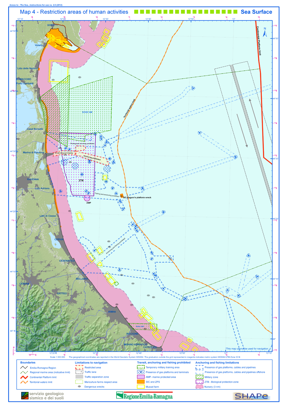
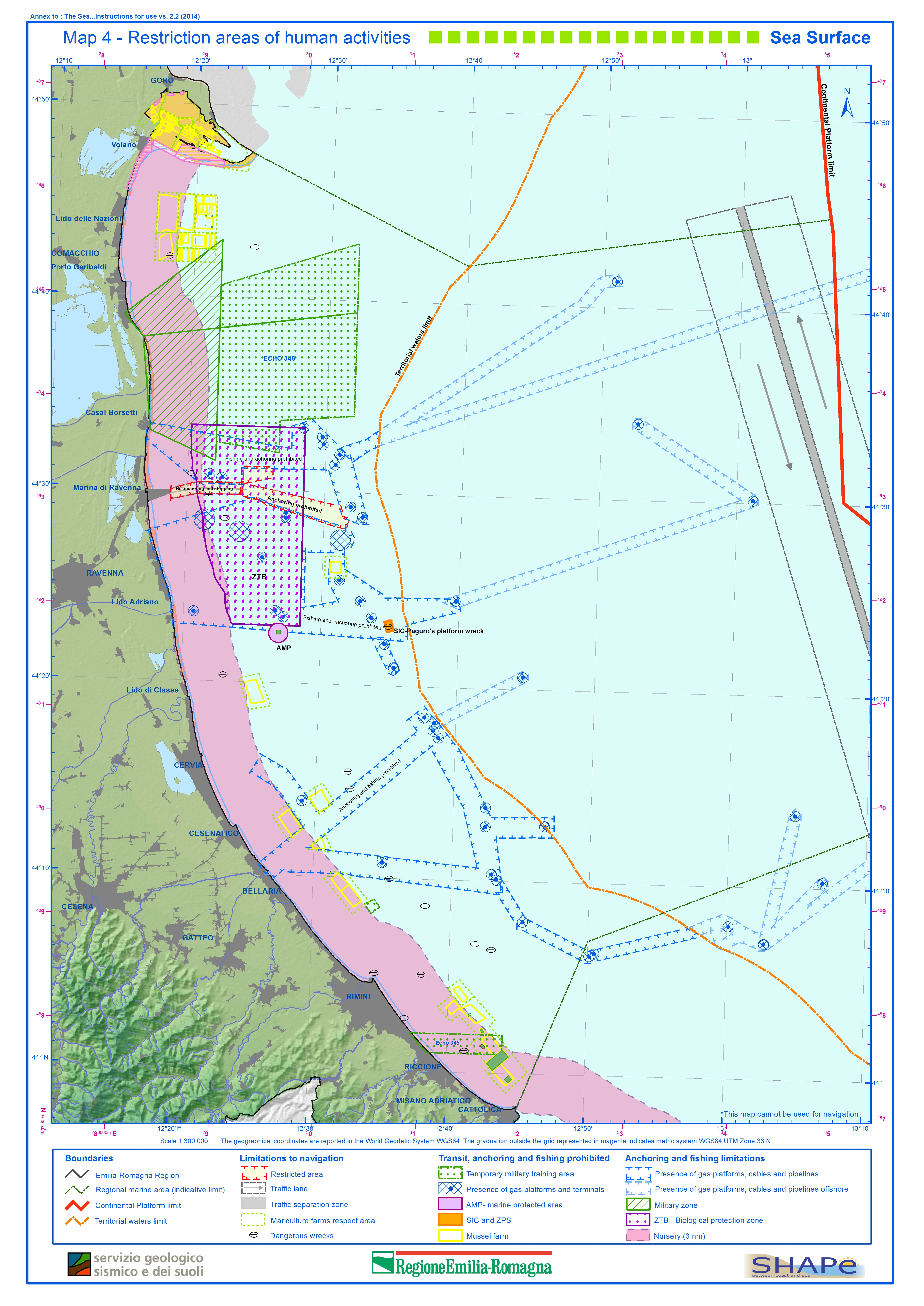
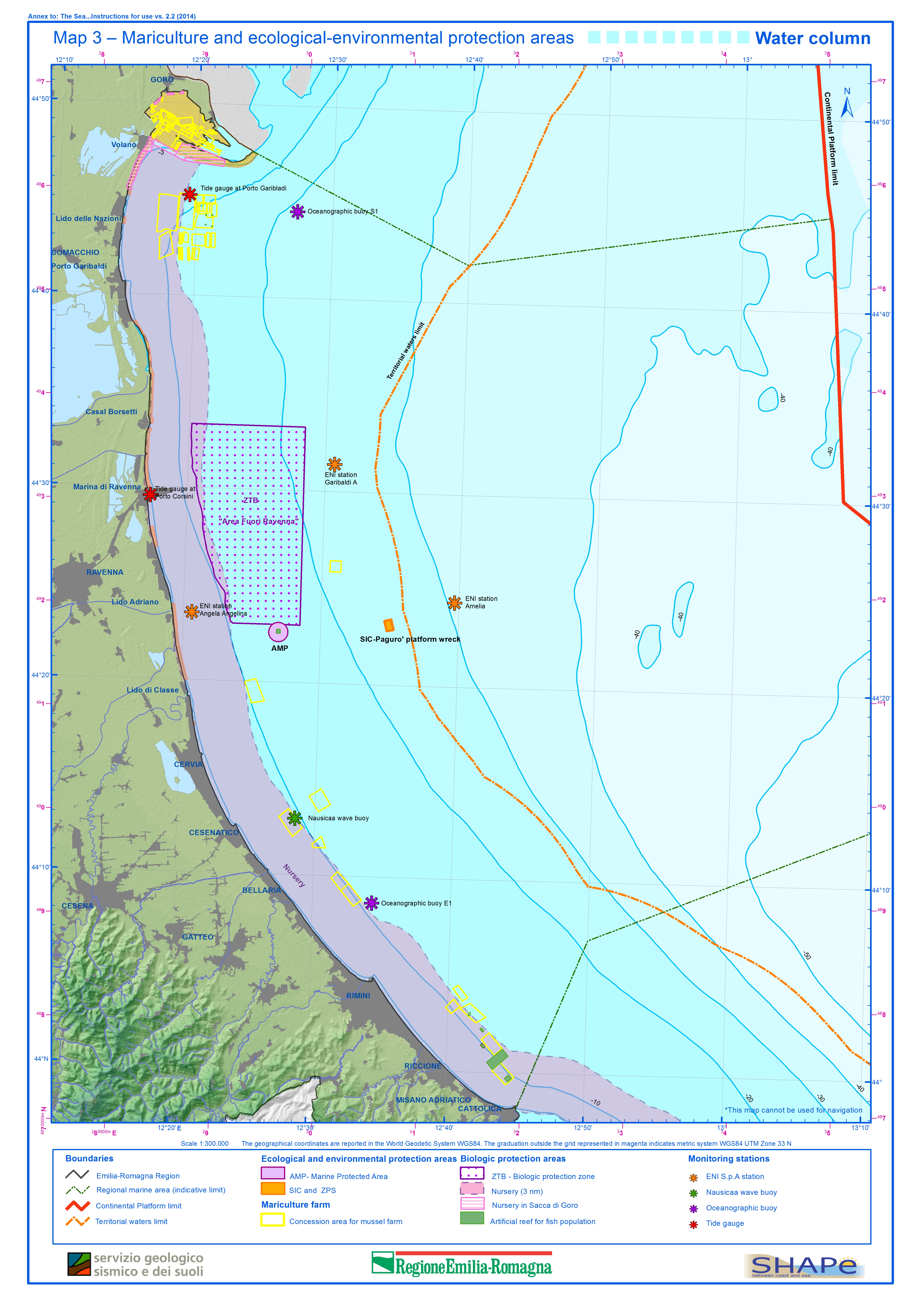
Box with explanatory notes (12 pages) + 4 thematic maps (scale 1:300.000), year of pubblication 2012, new version 2014
![THE SEA…instructions for use 2.2 THE SEA…instructions for use 2.2](https://ambiente.regione.emilia-romagna.it/en/geologia/publications/cartografia-geo-tematica/img_en.jpg/@@images/3fbf0500-e514-40d3-b274-f348943391ea.jpeg)
version 2014
9 maps in scale 1:250.000 of the three main acquifers A B C identified in the alluvial plane and technical report
![HYDROGEOLOGICAL MAP OF NORTHERN APENNINES, Upper catchment of Montone river HYDROGEOLOGICAL MAP OF NORTHERN APENNINES, Upper catchment of Montone river](https://ambiente.regione.emilia-romagna.it/en/geologia/publications/cartografia-geo-tematica/copertina_CartaMontone_500.jpg/@@images/241cc896-9a38-4d02-ba69-1fe057760d5b.jpeg)
1:25 000 scale
![copertina_200.jpg copertina_200.jpg](https://ambiente.regione.emilia-romagna.it/en/geologia/publications/cartografia-geo-tematica/copertina_200.jpg/@@images/9a180bab-3d3d-41a9-9090-92310df1c2cf.jpeg)
![THE SEA…instructions for use - version 2.0 THE SEA…instructions for use - version 2.0](https://ambiente.regione.emilia-romagna.it/en/geologia/publications/cartografia-geo-tematica/cop_200.jpg/@@images/249016dc-c163-48c2-97d7-cc2e483dd567.jpeg)
cover
Volume of "Illustartive Notes" and "Stratigraphic Tables" + Geological Cross Sections + Structural-Geological Map of the Emilia-Romagna Apennines in scale 1:250,000 (italian and english languages)
Volume 109 pages + Landslide susceptibility map of the Emilia-Romagna Region, Italy, in scale 1:250.000, italian and english languages, 2002
Map in scale 1:250.000
The Geological Landscape Map in scale 1:250.000
Volume of illustrative notes (italian language) + the Map in scale 1:25.000 (english and italian language)
![THE SEA…instructions for use - version 2.0 THE SEA…instructions for use - version 2.0](https://ambiente.regione.emilia-romagna.it/en/geologia/publications/cartografia-geo-tematica/Tav4_ing_01.jpg/@@images/ad868dac-58d4-4678-b1a4-f178d8228944.jpeg)
Map 4 –Restriction areas of human activities – Sea Surface
![Map 4 –Restriction areas of human activities – Sea Surface Map 4 –Restriction areas of human activities – Sea Surface](https://ambiente.regione.emilia-romagna.it/en/geologia/publications/cartografia-geo-tematica/Tav4_2014_ing.jpg/@@images/8327b030-458f-41e6-9b26-f1b7a13ca561.jpeg)
version 2014
![Map 3 –Mariculture and ecological-environmental protection areas –Water column Map 3 –Mariculture and ecological-environmental protection areas –Water column](https://ambiente.regione.emilia-romagna.it/en/geologia/publications/cartografia-geo-tematica/Tav3ok_ing_2014.jpg/@@images/1ea44832-ee7c-4b26-8f01-2a8e50340acf.jpeg)
version 2014