Soil Ecosystem Services
Methodology and use cases in Emilia-Romagna
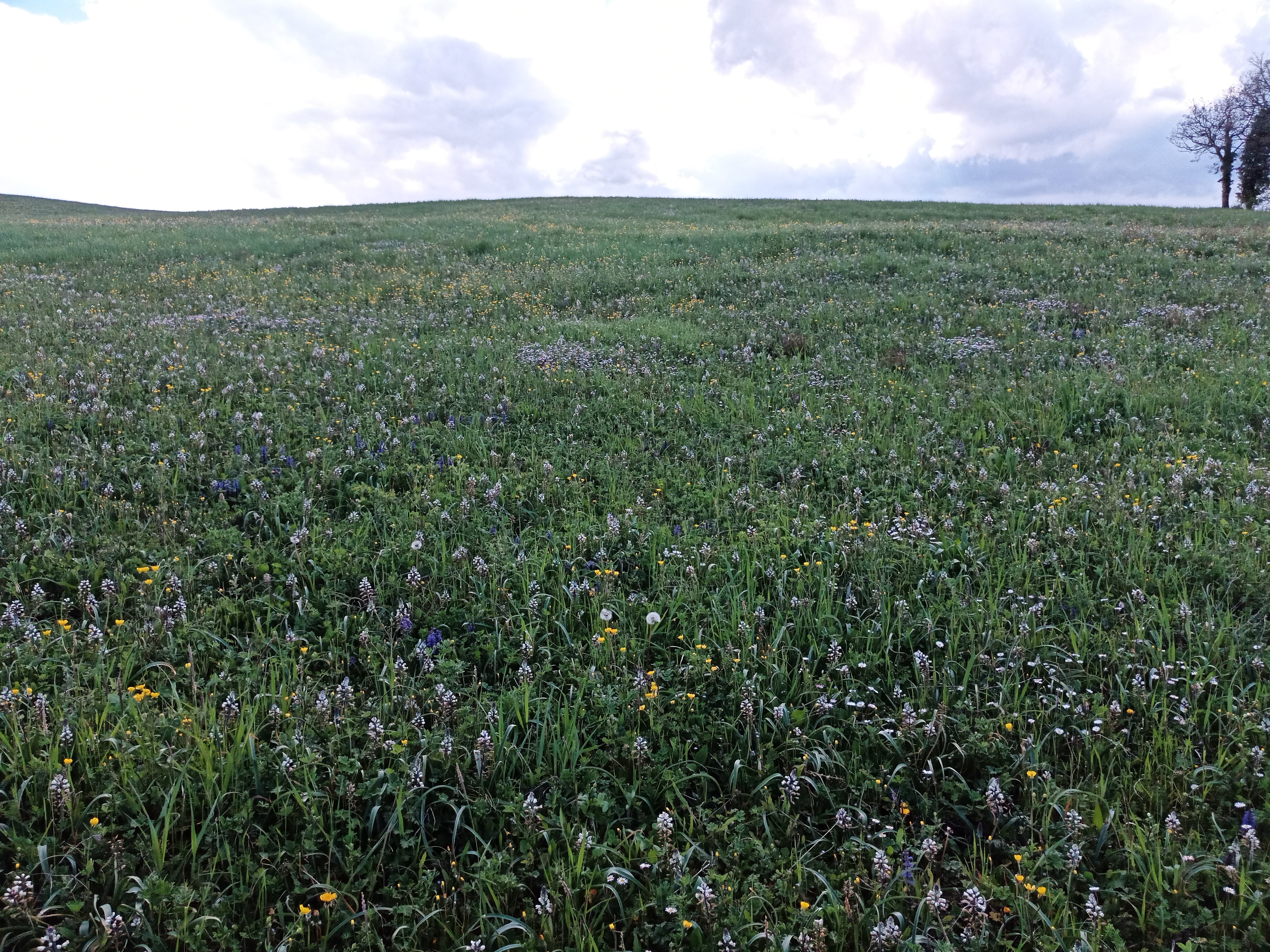
Soil performs different functions:
- biomass and food production;
- provides raw materials;
- is home to human activities and historical and archaeological archives;
- it is a reservoir of biodiversity, a carbon sink and a regulator of the water cycle and bio-chemical elements.
Through its functions, soil contributes to ecosystem services defined as "the benefits that people receive from ecosystems" (Millennium Ecosystem Assessment, 2005). The main ecosystem services provided by soil are:
- life support, by harboring plants, animals and human activities (and by cycling the elements of fertility);
- supply, by producing biomass and raw materials;
- regulation of hydrological and bio-geochemical cycles, and with the related purifying capacity;
- cultural values, as a historical-archaeological archive and a fundamental part of the landscape;
The functions that soils perform, and the ecosystem services related to them, vary in space, in relation to the characteristics of soils, and in time, in relation to the different conditions (climatic, management, etc.) around them: different soils provide different services and/or of different quality.
Evaluation scheme for Emilia-Romagna soils
CNR-IBE in Florence, in collaboration with the Geology, Soils and Seismic Area, has prepared a scheme for the evaluation of soil functions underlying ecosystem services for Emilia-Romagna soils for urban planning purposes.
Therefore, an indicator-based approach was adopted to assess and to map the multiple contributions of soils in providing ecosystem services, based on soil functions derived from soil data available for the 0-30 cm layer. Within this framework, different functions can be treated and mapped together, providing an efficient tool for modeling the heterogeneity of different soil functions at both regional and local scales.
The method consists of:
- definition of soil-based ecosystem services, using data derived from available thematic maps and economic and social needs;
- definition of appropriate indicators and their classification;
- assessment and mapping of the potential of soils to provide ecosystem services.
In 2023, new maps of soil characteristics (texture, organic C content and pH) covering the entire regional territory were produced (pixel size100mx100m ), so as to explicitly consider their spatial variability and associated estimation uncertainty. Soil properties such as bulk density, porosity, and saturated hydraulic conductivity were derived using locally calibrated pedofunctions and using other available information such as, for example, the land capability map.
Eight soil functions underlying ecosystem services were considered:
a) buffering capacity (BUF);
b) carbon-sequestration (CST);
c) erosion control (ERSPRO);
d) food provision (PRO);
e) biomass provision (BIOMASS);
f) water regulation (WAR);
g) water storage (WAS);
h) habitat for soil biodiversity (BIO).
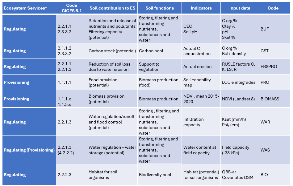
Ecosystem services, soil functions, and input data for estimation
The different indicators were standardized as a number from 0 to 1 by assigning 1 to the highest value found in the regional soils and 0 to the lowest value in the same area. The value 0 does not indicate that the service is absent but is the relative minimum in the study area. In this way it is possible to visualize "the value" of soil ecosystem services in a "radar" or "spider web" graph.
All indicators, with the exception of PRO, are rescaled to the 0-1 interval with the following function:
Xi 0-1= (Xi - Xmin)/(Xmax - Xmin)
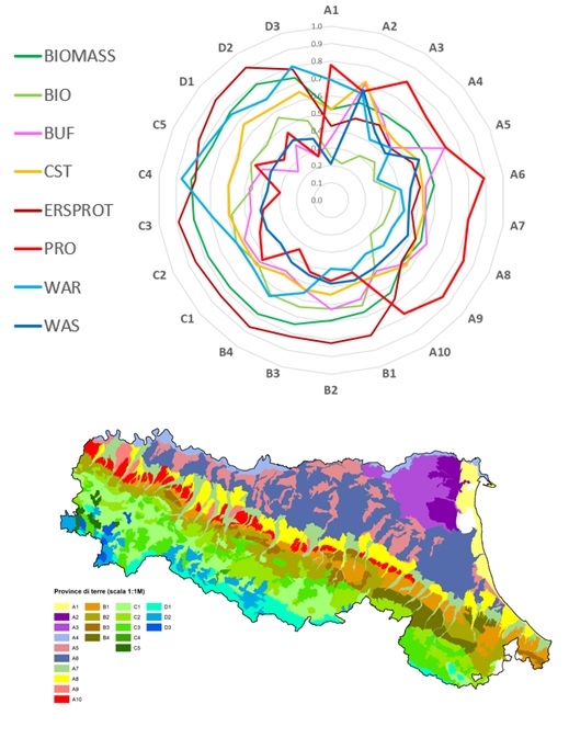
Average supply of soil functions in soil-landscape units at the scale 1:1,000,000
In regional soils, clear spatial patterns of soil functions linked to different soil-landscape units are identified.
The method allows clear links between decisions and ecosystem services to be established, allowing the risk of loss of services or the possibility of maintaining or enhancing specific services to be assessed under different policy and management options.
- Ungaro, F.; Tarocco, P.; Calzolari, C. Leveraging Soil Geography for Land Use Planning: Assessing and Mapping Soil Ecosystem Services Indicators in Emilia-Romagna, NE Italy. Geographies 2025, 5, 39. https://doi.org/10.3390/geographies 5030039
- Indicators-based assessment of soil-based ecosystem services at different spatial scales in Emilia-Romagna (NE Italy). POSTER IUSS, 2024 (PDF - 4,3 MB)
- Assessing soil ecosystem services in urban and peri-urban areas: from urban soils survey to providing support tool for urban planning. Land Use Policy, 99, December 2020, 105037
- A methodological framework to assess the multiple contributions of soils to ecosystem services delivery at regional scale. Geoderma, 261, January 2016, Pages 190-203;
- A methodological framework to assess the multiple contributions of soils to ecosystem services delivery at regional scale. Poster presentato al Workshop “Il suolo nella Pianificazione Territoriale”. Alghero, 2014 (PDF - 2,1 MB).
- Guidelines for assessing soil ecosystem services in urban environment and their management (PDF - 1,4 MB)
Use case
As part of the SAVE OUR SOIL FOR LIFE project, an assessment of the Ecosystem Services provided by soils was made for the three municipalities involved in the project (Forlì, Carpi and San Lazzaro di Savena), focusing in particular on the role played by areas that are not fully urbanized (urban green areas, agricultural interlocking areas, sports areas, private gardens, public gardens and parks and school green areas). These urban soils play an important role as they continue to store carbon, regulate water flows, purify water, and support biodiversity. Guidelines (PDF - 1,4 MB) have been prepared, useful for drawing up soil ecosystem service maps.
A pedological survey of urban soils in the municipality of Forli was carried out in 2023 to make maps of great detail (25m pixels) of the ecosystem services provided by soils for the purpose of drafting the new General Urban Plan.
- Assessment of joint soil ecosystem services supply in urban green spaces: A case study in Northern Italy. Urban Forestry & Urban Greening, 67, January 2022, 127455
- Ecosystem services of urban soils. The case of Forlì municipality. 2024 (PDF - 9,2 MB)
- Assessing and mapping soil ecosystem services in urban and peri-urban areas. IUSS, 2024 (PDF - 8,3 MB)
Maps
Given the multifunctionality of soils, it is important to highlight areas where soils provide more functions and thus potentially more ecosystem services. These are defined as "hotspots," mediating the term already widely used in the field of biodiversity: "Hotspots were identified and mapped as areas capable of providing multiple functions whose normalized value was greater than the 70th percentile of the observed distribution. "
As part of the SOS4LIFE project, six maps (BUF, BIO, WAS, WAR, PRO, CST) with 500 m x 500m accuracy were produced for the entire alluvial plain of Emilia-Romagna region. To compare the different indicators with each other these are standardized as a number from 0 to 1, making 1 the maximum value and 0 the minimum relative value in the considered area.
In 2023 these maps were updated and now cover the entire region (raster with 100mx100m pixels), adding two more ecosystem services namely ERSPRO and BIOMASS.
A map with a synthetic index in 5 classes summing the four most established ecosystem services (PRO, CST, WAR, BUF) is also available. Maps of ecosystem services provided by regional soils are freely downloadable from MinERva site.
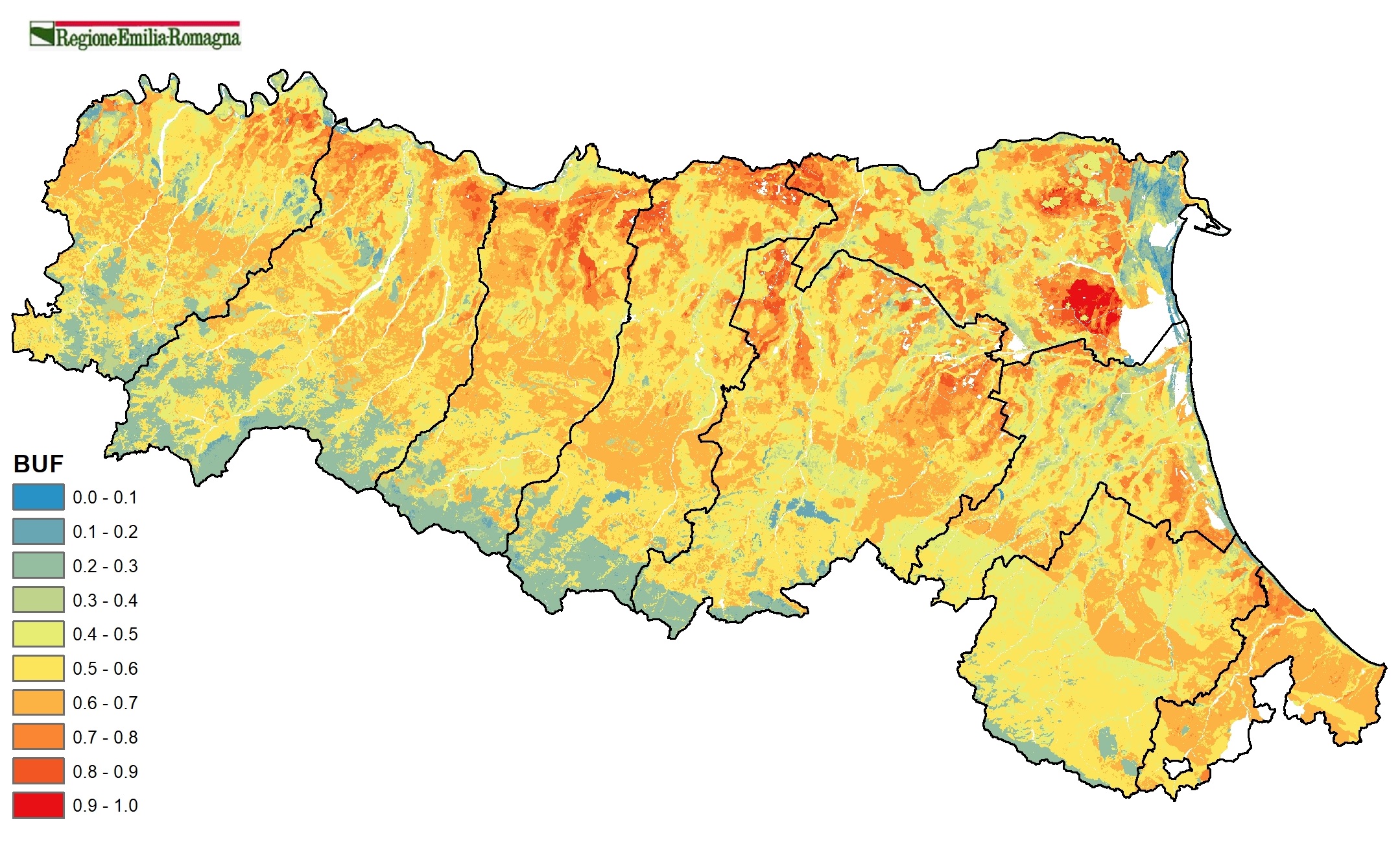
a) BUF. Buffering capacity
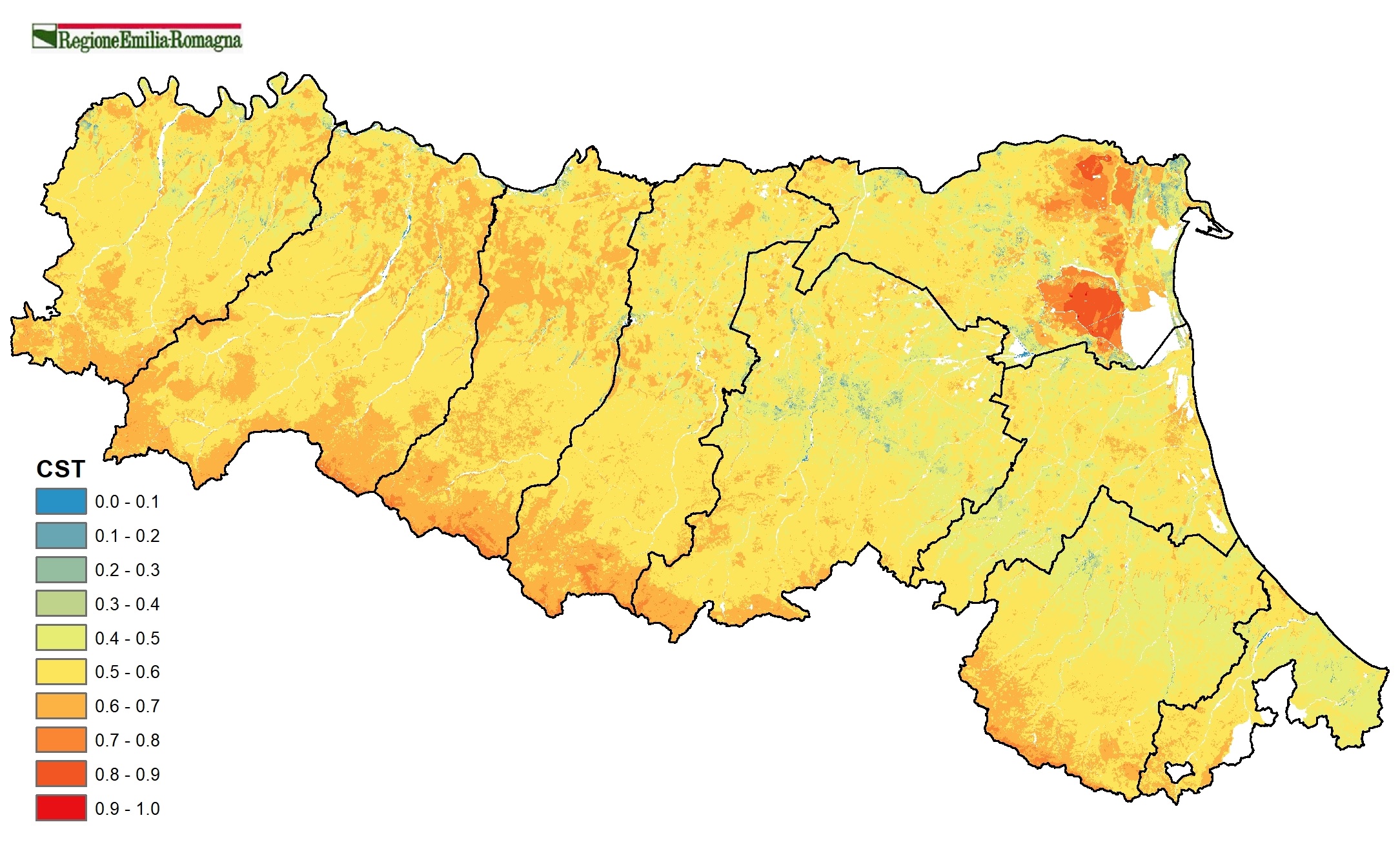
b) CST. Carbon sequestration
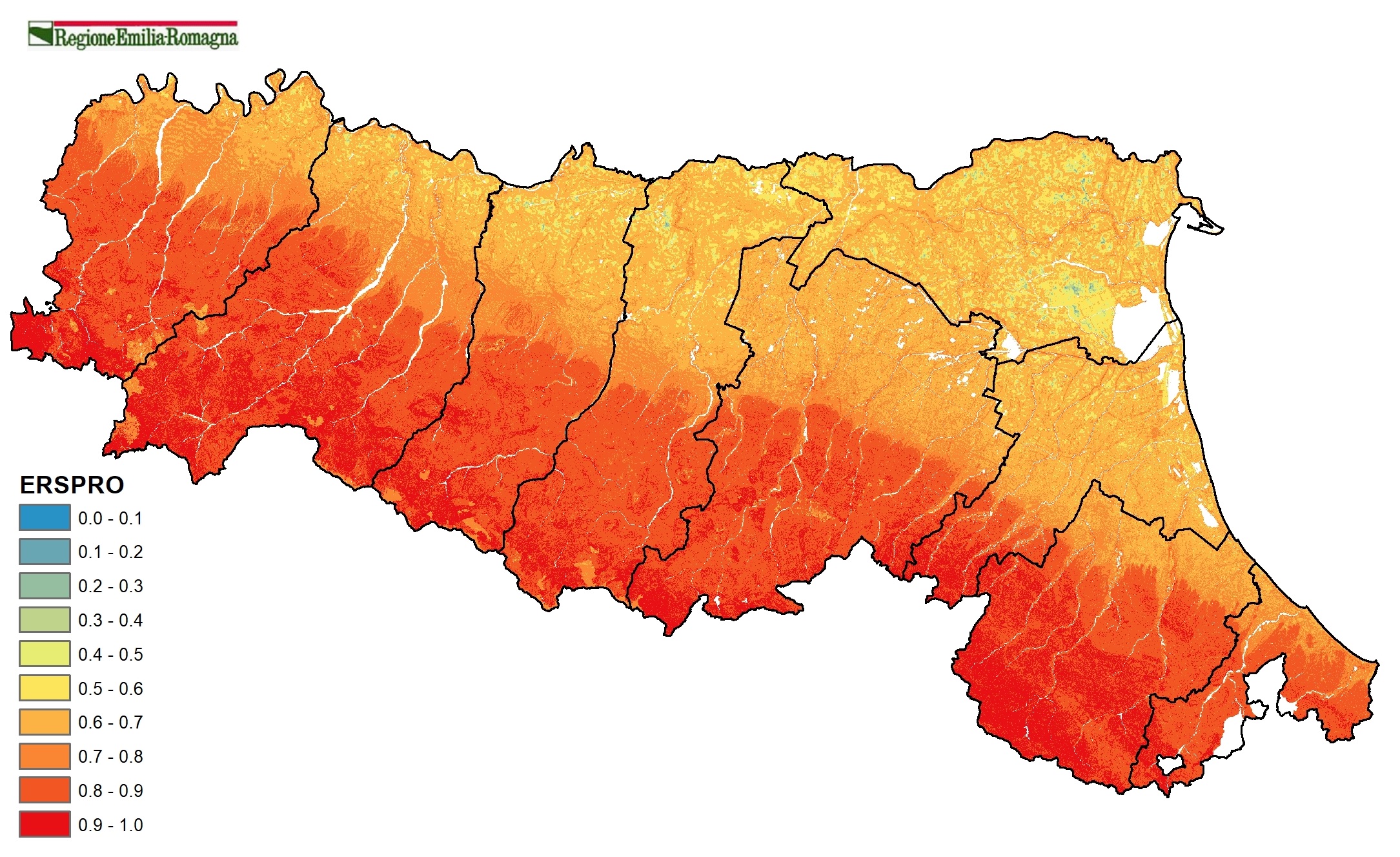
c) ERSPRO. Erosion control
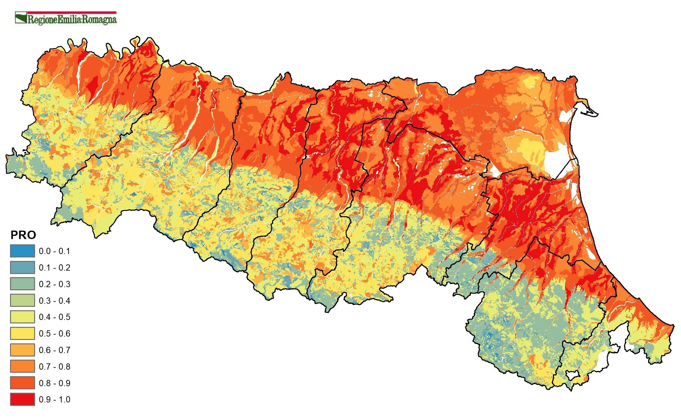
d) PRO. Food provision
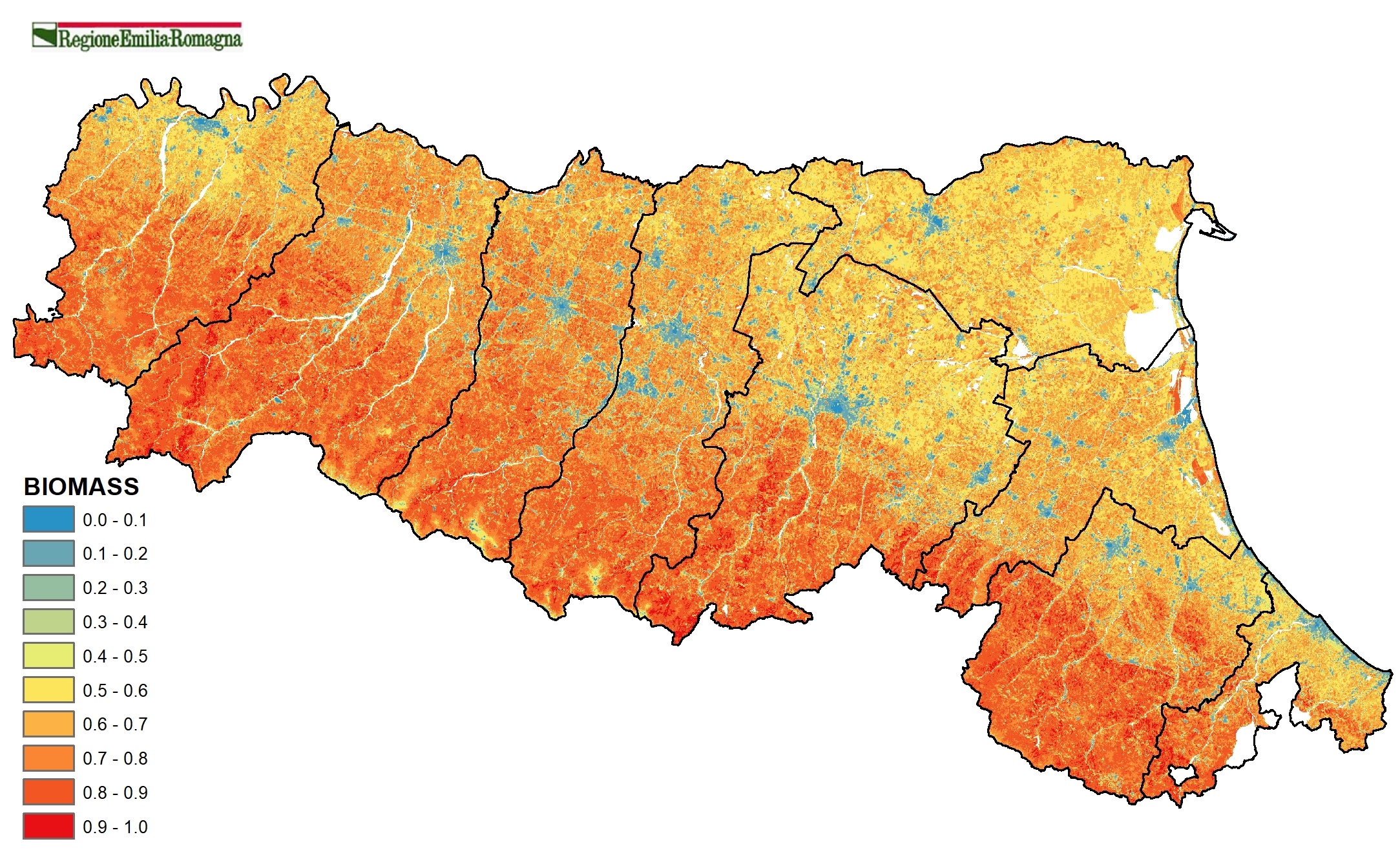
e) BIOMASS. Biomass provision
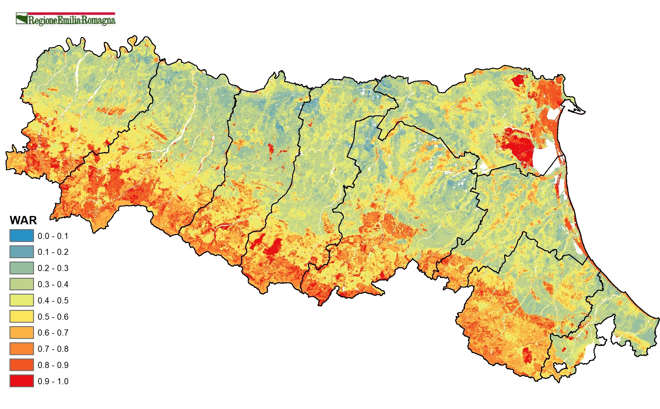
f) WAR. Water regulation
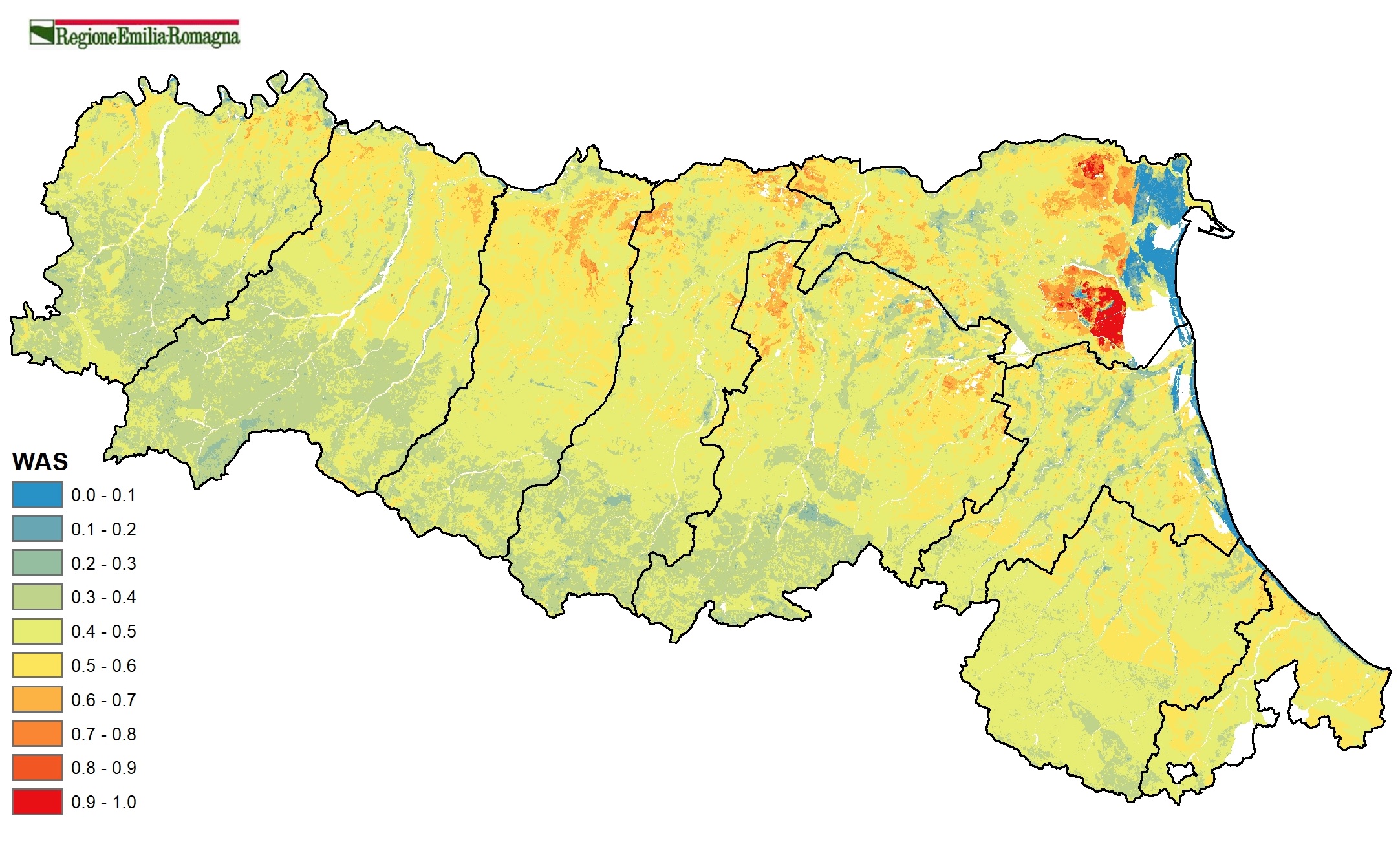
g) WAS. Water storage
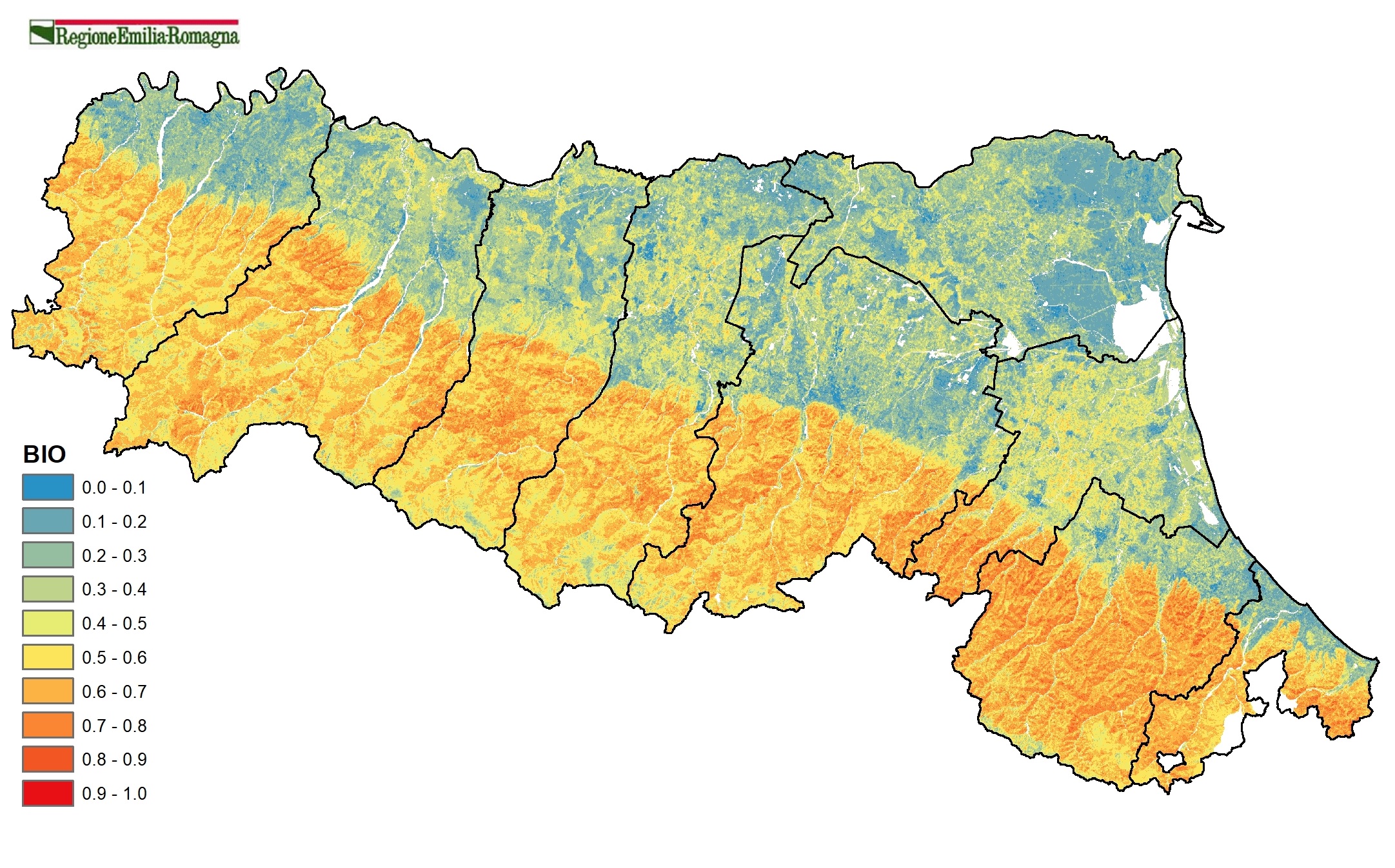
h) BIO. Habitat for soil biodiversity
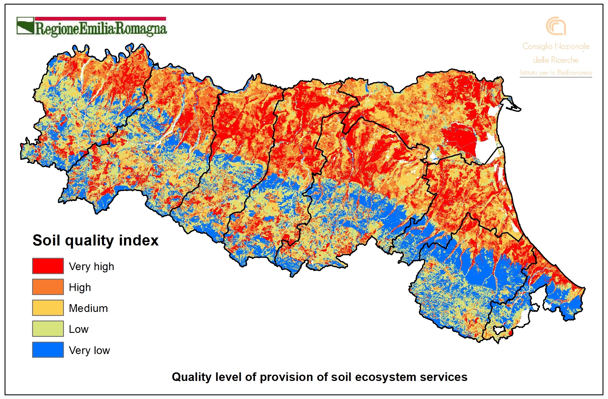
h) IQ4. Synthetic soil quality index
Publications
- From Fertile Grounds to Sealed Fields: Assessing and Mapping Soil Ecosystem Services in Forlì’s Urban Landscape (NE Italy). Land 2025, 14(4), 719; https://doi.org/10.3390/land14040719
- Soil threats in Europe: Status, methods, drivers and effects on ecosystem services (2016)
- Millenium Ecosystem Assesment Board. Ecosystems and human well-being. 2005
- Toth et al. Continental-scale assessment of provisioning soil functions in Europe. Ecological Processes 2013, 2:32. DOI: 10.1186/2192-1709-2-32 - Ecological Processes.
- Influence of 150 Years of Land Use on Anthropogenic and Natural Carbon Stocks in Emilia-Romagna Region (Italy) 2011. DOI: 10.1021/es1039437 - Environmental Science & Technology,
- Schulte et al. Making the Most of Our Land: Managing Soil Funcions from Local to Continental Scale. 2015. DOI: 10.3389/fenvs.2015.00081 (PDF - 2.3 MB)
- Coyle et al. A Functional Land Management conceptual framework under soil drainage and land use scenarios. DOI:10.1016/j.envsci.2015.10.012. Environmental Science & Policy 56 (2016) 39–48
