The geological support to subsidence analisys
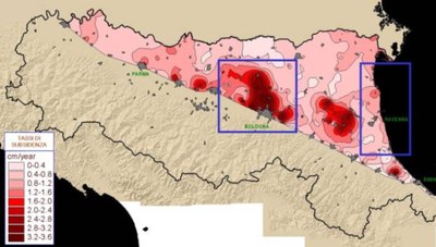
| Since the last decades subsidence in Emilia-Romagna (ER) Po Plain represents one of the most critical problems due to the several hazards linked to this phenomenon. Despite expected values of natural subsidence in quaternary alluvial plain are about 0.1-0.2 cm/y, for most of the ER plain values > 0.4 with peaks up to 3.8 have been detected |  |
| Consequently, flooding of lowered areas by river inundations or sea storms and local inversion of water flow within river and artificial channels are becoming very much common. |
Fig.1 Subsidence in Emilia-Romagna plain from 1973/93-1999; Delimitation of two critical areas, object of specific studies; (from ARPA Ingegneria Ambientale, Italy) |
Two areas of ER are particularly exposed to such subsidence-induced risks:
A) highly-populated alluvial fans at the Northern Apennine foothill, such as the Reno River fan (Bologna city), where the highest subsidence value of the region has been measured (6 m lowering in 50 years);
B) the coast and delta plain where subsidence rate is up to 0.8 to 1.6 cm/y After the development of a ER monitoring system of subsidence, consisting of a network for high-precision geodetic levelling, several studies indicate that water and water-gas pumping from the Po Plain subsurface is the main responsible for regional subsidence. Thus the identification, 3D mapping, and lithologic and hydrogeologic characterization of aquifers and aquitard are considered the starting point for subsidence comprehension, modelling and future previsions.
The Geological Survey of Regione Emilia-Romagna is developing a method of subsurface geologic reconstruction for modelling purposes performed by the following steps:
1. creation of a geognostic data base including water-well stratigraphy, hydrocarbon-well electric-log, geotechnical and hydrogeological parameters;
2. analysis of seismic lines available from oil industries (ENI-AGIP oil company is widely involved in the exploitation of Po Plain) to define the overall structural assessment of quaternary sediments;
3. drilling continuous-core boreholes (up to 200 m depth) to verify stratigraphic correlation and facies definition based on geognostic data base (for ER cores are available from the national geological mapping project);
4. field geological survey of the Apennine foothill, river valleys and upper alluvial plain terraces to define water recharge characteristics;
5. creation of a grid of geologic cross-sections (spaced from hundred m to few km depending on data density and model scale) where all stratigraphic and hydrogeologic data are reported, interpolated and geometrically verified;
6. creation of isopach and isobath maps to quantify aquifers geometry;
7. collection of data on water exploitation to quantify the extractions and their spatial distribution (both lateral and vertical);
8. definition the geologic framework of boundary conditions for water flux modelling.
Using this approach the Geological Survey has been recently involved in two projects for subsidence analysis and previsions: “Hydrogeologic and subsidence modelling of Reno River alluvial fan” and “Analysis of subsidence of Emilia-Romagna coast related to subsurface water exploitation”. In these studies the subsurface geology model of each area is used for a) prediction of aquifers and aquitard geometry and b) water flux and subsidence mathematical modelling.
Documents
Presentation "The geologic support to subsidence analysis in Emilia-Romagna alluvial plain" (6.44 MB)
